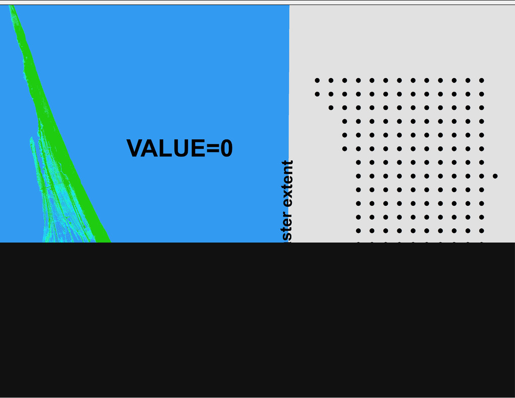
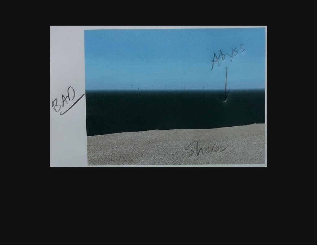
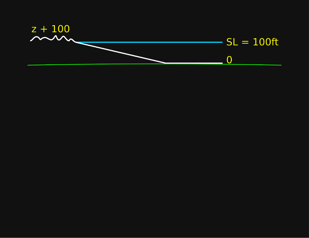
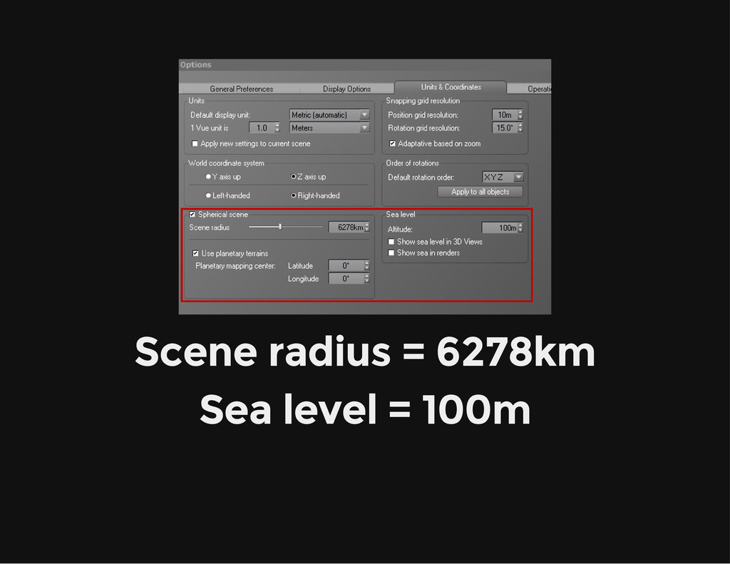
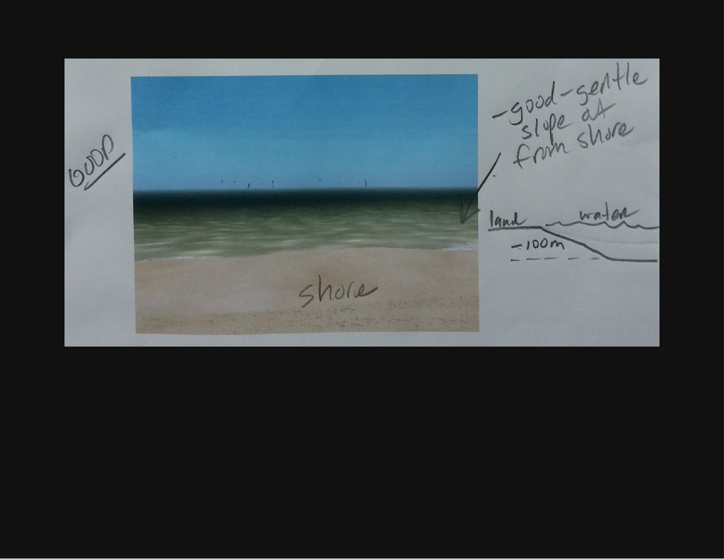
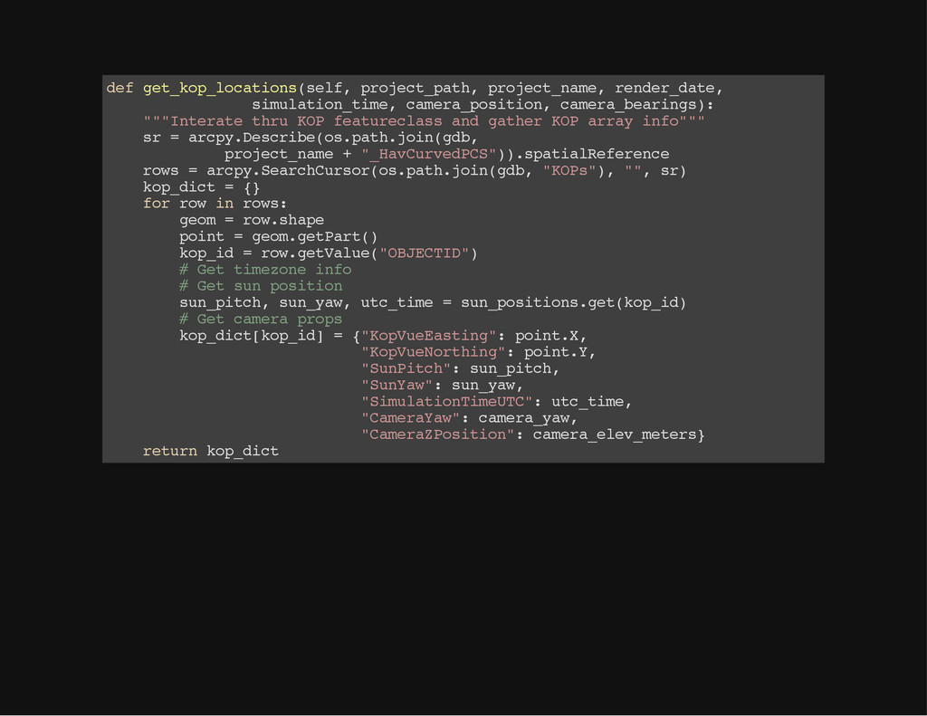
0 , 0 , 0 , 0 , 0 , 0 , 0 , 0 , 0 , 0 , 0 , 0 , 0 , 0 , 0 , 0 , 0 , 0 , 0 , 0 , 0 , 0 , 0 , 0 , 0 , 0 0 . 8 0 7 5 6 3 2 7 8 2 3 0 6 0 4 7 , 0 . 8 0 7 5 8 4 2 3 5 8 4 3 6 8 9 8 8 , 0 . 8 0 7 2 4 4 7 5 8 1 3 3 7 1 3 9 9 , 0 . 8 0 7 0 1 2 9 1 8 2 4 9 5 8 3 8 8 , 0 . 8 0 7 2 4 9 0 . 8 0 7 4 6 4 0 1 1 5 7 5 9 9 1 2 4 , 0 . 8 0 7 5 2 6 2 9 0 7 1 5 1 5 9 5 8 , 0 . 8 0 7 2 3 5 3 1 8 3 0 2 3 2 4 3 1 , 0 . 8 0 7 0 2 4 0 2 0 4 4 1 2 1 8 3 5 , 0 . 8 0 7 3 7 0 . 8 0 7 2 3 9 6 5 2 3 1 2 9 6 2 3 5 , 0 . 8 0 7 1 8 4 1 4 1 3 5 4 7 9 0 3 3 , 0 . 8 0 6 7 5 6 4 3 9 8 1 1 8 2 6 6 5 , 0 . 8 0 6 5 7 1 3 2 4 1 2 4 5 7 5 , 0 . 8 0 6 5 8 3 7 0 . 8 0 6 6 9 2 2 6 0 8 3 2 3 7 8 6 6 , 0 . 8 0 6 4 2 4 8 5 8 3 1 3 0 1 3 2 5 , 0 . 8 0 6 0 9 6 6 0 1 5 3 4 6 8 9 2 1 , 0 . 8 0 6 0 7 7 4 8 4 3 9 1 8 7 4 8 8 , 0 . 8 0 6 1 0 0 . 8 0 6 0 9 9 4 5 1 2 9 5 1 0 8 7 4 , 0 . 8 0 5 9 1 6 3 5 4 1 8 8 1 5 4 2 2 , 0 . 8 0 5 8 1 6 4 3 4 4 6 3 4 4 4 6 4 , 0 . 8 0 5 8 8 9 0 4 3 9 8 4 1 3 3 7 5 , 0 . 8 0 5 9 6 0 . 8 0 5 6 6 7 9 5 0 0 7 1 5 8 5 6 5 , 0 . 8 0 5 6 5 6 0 1 6 6 9 9 8 2 8 8 9 , 0 . 8 0 5 7 6 2 1 7 0 2 7 5 4 5 6 1 6 , 0 . 8 0 5 8 3 2 8 2 0 5 8 5 8 5 6 9 2 , 0 . 8 0 5 9 1 0 . 8 0 5 4 0 2 5 0 6 7 6 2 5 0 8 6 9 , 0 . 8 0 5 3 9 5 5 0 1 1 0 1 4 7 7 2 8 , 0 . 8 0 5 6 3 8 0 2 7 5 8 7 1 8 0 6 2 , 0 . 8 0 5 8 0 2 6 6 0 6 2 1 4 1 6 9 2 , 0 . 8 0 5 9 1 0 . 8 0 5 2 1 3 2 9 4 5 4 4 6 5 3 9 6 , 0 . 8 0 5 1 7 9 8 6 9 2 2 9 7 3 3 2 8 , 0 . 8 0 5 4 3 8 4 8 4 9 8 7 8 0 5 1 3 , 0 . 8 0 5 6 8 7 4 2 3 4 3 4 4 5 2 4 3 , 0 . 8 0 5 8 0 0 . 8 0 5 0 8 7 7 8 6 3 4 6 1 7 7 3 9 , 0 . 8 0 5 1 4 2 6 4 4 2 3 4 2 5 3 1 9 , 0 . 8 0 5 2 3 6 8 6 4 4 3 8 1 2 3 8 1 , 0 . 8 0 5 2 6 2 0 3 7 3 2 1 8 2 9 5 5 , 0 . 8 0 5 3 9 0 . 8 0 5 1 8 5 6 8 7 4 9 0 5 8 9 8 3 , 0 . 8 0 4 9 9 9 8 5 9 3 6 3 2 3 3 2 6 , 0 . 8 0 4 9 3 2 7 1 1 8 8 3 3 4 8 2 5 , 0 . 8 0 5 0 7 8 2 8 7 1 4 4 7 7 9 0 3 , 0 . 8 0 5 3 6 0 . 8 0 5 5 9 4 8 6 5 5 9 0 8 2 6 6 , 0 . 8 0 5 3 8 4 9 3 3 2 3 9 9 2 1 5 5 , 0 . 8 0 5 1 9 0 4 9 6 4 6 1 2 9 7 8 1 , 0 . 8 0 5 2 4 8 6 7 9 0 6 9 8 6 3 0 8 , 0 . 8 0 5 5 2 1 0 . 8 0 6 3 3 1 0 5 3 6 9 9 2 0 3 8 8 , 0 . 8 0 5 9 5 2 2 7 3 0 4 3 4 4 1 9 7 , 0 . 8 0 5 5 9 7 5 3 7 2 4 1 2 1 9 8 5 , 0 . 8 0 5 5 0 6 8 1 9 8 6 7 8 6 4 9 9 , 0 . 8 0 5 7 1 0 . 8 0 6 8 1 5 0 9 7 3 8 0 4 6 1 8 7 , 0 . 8 0 6 2 5 2 3 8 8 4 3 7 6 2 3 2 6 , 0 . 8 0 5 7 9 5 0 6 1 2 6 0 2 9 8 2 1 , 0 . 8 0 5 4 9 2 5 7 1 0 6 5 7 6 7 4 4 , 0 . 8 0 5 6 1 0 . 8 0 7 0 3 1 2 6 3 5 8 2 2 8 4 6 1 , 0 . 8 0 6 5 2 0 5 0 3 3 9 7 0 9 3 4 7 , 0 . 8 0 5 8 8 0 3 7 5 9 6 2 8 5 7 7 8 , 0 . 8 0 5 4 9 5 5 9 8 9 3 6 2 1 3 1 4 , 0 . 8 0 5 5 8 0 . 8 0 7 0 7 3 5 9 4 3 9 8 5 1 6 3 4 , 0 . 8 0 6 5 8 9 6 1 0 0 8 7 2 6 7 0 4 , 0 . 8 0 6 0 4 3 5 8 4 1 1 6 8 8 4 2 6 , 0 . 8 0 5 7 4 7 2 6 8 4 0 3 2 6 2 3 8 , 0 . 8 0 5 6 2 0 . 8 0 6 9 5 6 2 7 9 2 6 1 2 4 5 9 1 , 0 . 8 0 6 6 1 4 0 1 1 1 6 0 8 5 9 1 8 , 0 . 8 0 6 3 5 9 3 1 3 8 2 3 3 6 4 1 2 , 0 . 8 0 6 1 8 6 9 6 2 6 8 7 9 9 1 6 2 , 0 . 8 0 5 8 8 0 . 8 0 6 8 6 2 4 1 5 2 7 7 4 2 7 7 5 , 0 . 8 0 6 6 4 3 5 7 7 4 2 5 2 1 1 7 6 , 0 . 8 0 6 5 3 2 7 3 3 6 1 8 8 9 3 9 9 , 0 . 8 0 6 4 6 8 1 3 9 0 4 9 3 8 4 7 5 , 0 . 8 0 6 2 6 0 . 8 0 6 8 0 3 1 0 4 6 3 8 6 9 6 4 2 , 0 . 8 0 6 5 0 1 4 4 5 6 2 4 2 8 7 9 4 , 0 . 8 0 6 3 6 3 8 8 5 3 1 4 0 3 7 1 3 , 0 . 8 0 6 4 2 5 3 3 3 2 7 3 0 8 3 0 8 , 0 . 8 0 6 4 5 0 . 8 0 6 5 6 4 3 7 7 8 3 3 5 5 2 5 , 0 . 8 0 6 3 0 6 3 5 5 7 7 5 5 6 7 9 7 , 0 . 8 0 6 2 1 8 1 9 1 3 1 2 5 8 8 8 7 , 0 . 8 0 6 3 3 5 5 6 5 8 1 9 8 6 8 0 9 , 0 . 8 0 6 4 3 3 0 . 8 0 6 8 7 2 6 8 6 2 8 8 9 3 9 8 2 , 0 . 8 0 6 7 2 0 5 2 0 9 5 6 5 3 8 9 , 0 . 8 0 6 3 6 3 0 5 4 1 3 3 9 1 4 7 4 , 0 . 8 0 6 2 9 9 4 0 9 4 8 4 5 4 5 3 7 , 0 . 8 0 6 2 6 9 0 . 8 0 6 9 4 9 2 1 4 2 3 0 2 0 5 8 2 , 0 . 8 0 6 8 0 0 3 7 3 6 1 8 2 9 4 3 8 , 0 . 8 0 6 5 2 5 2 5 2 9 9 7 7 9 2 7 6 , 0 . 8 0 6 4 8 9 2 1 5 4 0 2 4 8 7 5 2 , 0 . 8 0 6 5 8 0 . 8 0 6 9 4 4 8 2 0 8 4 9 5 5 8 9 9 , 0 . 8 0 7 1 0 0 0 7 3 4 2 2 4 1 4 4 1 , 0 . 8 0 6 7 8 6 7 7 7 8 8 6 2 9 2 8 3 , 0 . 8 0 6 4 2 6 7 5 8 1 5 3 2 9 2 9 , 0 . 8 0 6 2 8 4
![THE END Chad Cooper [email protected] https://speakerdeck.com/supercooper https://github.com/chadcooper/argis- bridging-gis-python](https://files.speakerdeck.com/presentations/55477ab0f6fb013021402a4caaa937e0/slide_123.jpg)