Upgrade to Pro
— share decks privately, control downloads, hide ads and more …
Speaker Deck
Sign up for free
Menu
Search
Features
All features
Private URLs
Password Protection
Custom URLS
Scheduled publishing
Remove Branding
Restrict embedding
Deck Collections
Notes
Features
All features
Private URLs
Password Protection
Custom URLS
Scheduled publishing
Remove Branding
Restrict embedding
Deck Collections
Notes
Explore
Featured decks
Featured speakers
Programming
Technology
Storyboards
Explore
Featured decks
Featured speakers
Programming
Technology
Storyboards
Pricing
Search
Sign in
Sign up for free
ZFXY: a 3D spatio-temporal tiling scheme propos...
Search
Sponsored
·
SiteGround - Reliable hosting with speed, security, and support you can count on.
→
Hidenori FUJIMURA
March 16, 2022
Technology
340
0
Share
Embed
Copy iframe code
Copy JS code
Copy link
Start on current slide
ZFXY: a 3D spatio-temporal tiling scheme proposal for optimized data access
UN Open GIS Initiative Monthly VTC, 2022-03
Hidenori FUJIMURA
March 16, 2022
More Decks by Hidenori FUJIMURA
See All by Hidenori FUJIMURA
みんなに伝わる防災マップ
hfu
0
180
未来の繁栄のためのスマート地図
hfu
0
210
Smart Maps for the prosperity in the future
hfu
0
300
Smart Maps and Bazaar
hfu
0
230
Sensemaking with Smart Maps
hfu
0
160
Smart Maps for the United Nations, with the United Nations
hfu
0
210
UN Smart Maps
hfu
0
250
スマート地図バザールによる地図XMLのタイル配信
hfu
0
150
国土地理院におけるベース・レジストリの整備とDX推進への取り組み
hfu
0
360
Other Decks in Technology
See All in Technology
Refining Active Record
shugo
0
140
事業活動を AI Ready にする攻めと守りのデータエンジニアリング / data-engineering-for-ai-ready-business
pei0804
7
2.8k
1つのリクエストを追って理解する - llm-dのP/D分離
akhino
1
150
Local CI × GitHub Actions
gogutan
2
140
TinyGoでオブザーバビリティ?OpenTelemetryはTinyGoで使えるのか / Is OpenTelemetry available in TinyGo environment?
ymotongpoo
2
140
USB PDを使ってスマホを労わりたい
raspython3
0
170
初対面のメンバーがチームを組み、Claude Codeでゼロからサービスをリリース
mkdev10
1
130
10年後、Engineering 行為を剥奪されるとして、わたしたちは、どう、何を創ればいいだろうか。 / If Engineering Is Taken Away in 10 Years, How and What Should We Create?
bitkey
PRO
1
180
Conditional PED-ANOVA: Hyperparameter Importance in Hierarchical & Dynamic Search Spaces
pfn
PRO
0
120
Snapshot Testing in Practice: Predictable and Reliable SwiftUI Views
fespinoza
0
220
「Docker Desktop不要の時代」は 来たのか?
ueponx
0
680
"優秀な誰か"の下位互換にならないために
yut0naga1_fa
1
1.8k
Featured
See All Featured
Abbi's Birthday
coloredviolet
4
10k
The Curious Case for Waylosing
cassininazir
1
570
Self-Hosted WebAssembly Runtime for Runtime-Neutral Checkpoint/Restore in Edge–Cloud Continuum
chikuwait
0
890
Tips & Tricks on How to Get Your First Job In Tech
honzajavorek
1
800
Creating an realtime collaboration tool: Agile Flush - .NET Oxford
marcduiker
35
2.6k
Designing for Performance
lara
612
70k
Measuring Dark Social's Impact On Conversion and Attribution
stephenakadiri
2
310
The Invisible Side of Design
smashingmag
301
52k
10 Git Anti Patterns You Should be Aware of
lemiorhan
PRO
659
62k
ピンチをチャンスに:未来をつくるプロダクトロードマップ #pmconf2020
aki_iinuma
128
56k
Code Reviewing Like a Champion
maltzj
529
40k
The SEO Collaboration Effect
kristinabergwall1
1
590
Transcript
ZFXY: a 3D spatio-temporal tiling scheme proposal for optimized data
access Hidenori (UN Vector Tile Toolkit / Geospatial Information Authority of Japan)
Introduction of background: 3D geospatial projects in Japan
GSI secured budget for point cloud data (regular budget [2
million USD] + external supplementary budget)
Shizuoka Prefecture is completing provision of point cloud data as
Open Data
City Bureau of MLIT has been leading 3D city modeling
throuh Project PLATEAU
Tokyo Metropolitan Government started Tokyo Digital Twin Project
3D Spatial Information Infrastructure project led by Ministry of Economy,
Trade, and Industry / IPA DADC
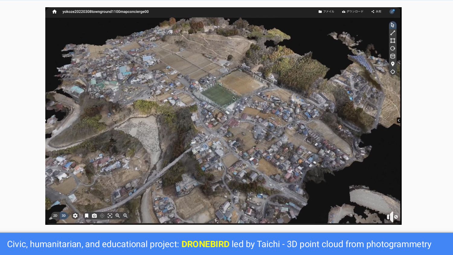
Civic, humanitarian, and educational project: DRONEBIRD led by Taichi -
3D point cloud from photogrammetry
Our UNVT colleague Takayuki appointed in 3D spatial information infrastructure
design committee by IPA DADC.
UNVT Community is working on: How can we optimize access
to 3D geospatial data?
Tile: industry standard in web maps {z}/{x}/{y} z: zoom index,
x: west-east index, y: north-south index
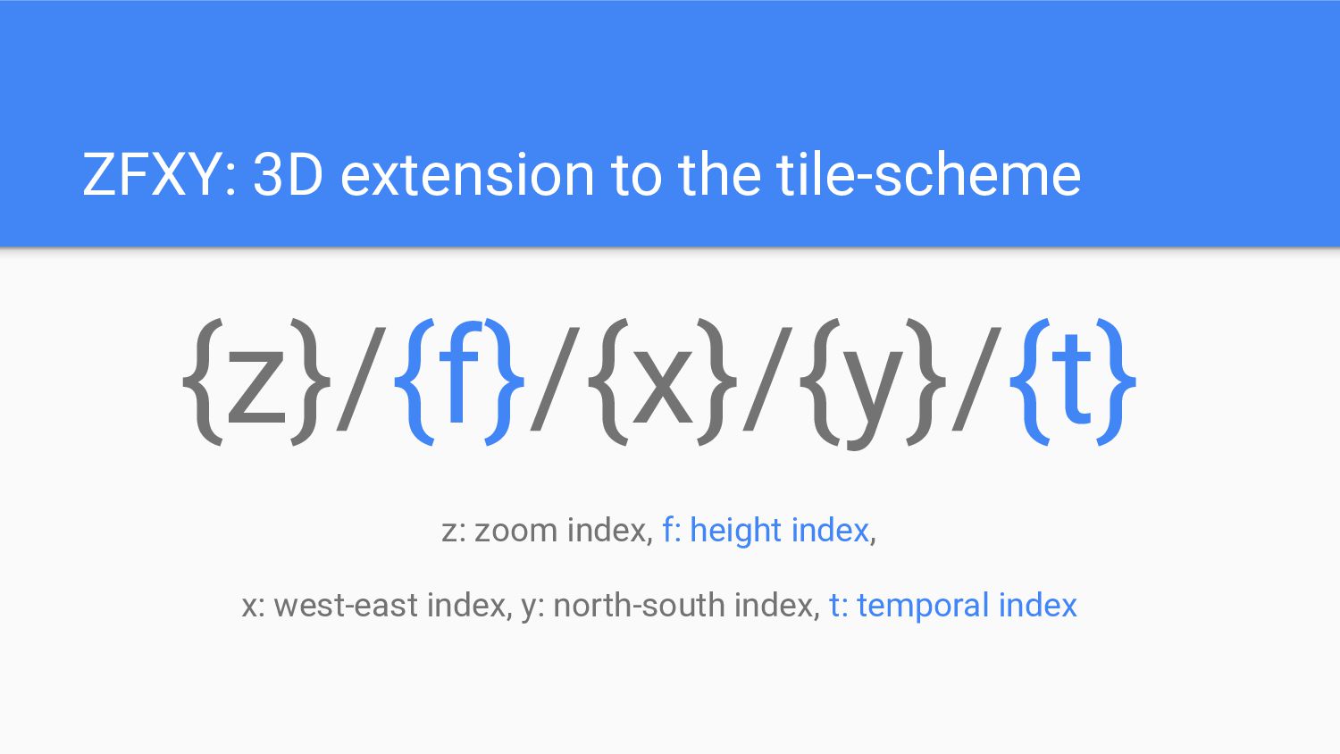
ZFXY: 3D extension to the tile-scheme {z}/{f}/{x}/{y} z: zoom index,
f: height index, x: west-east index, y: north-south index
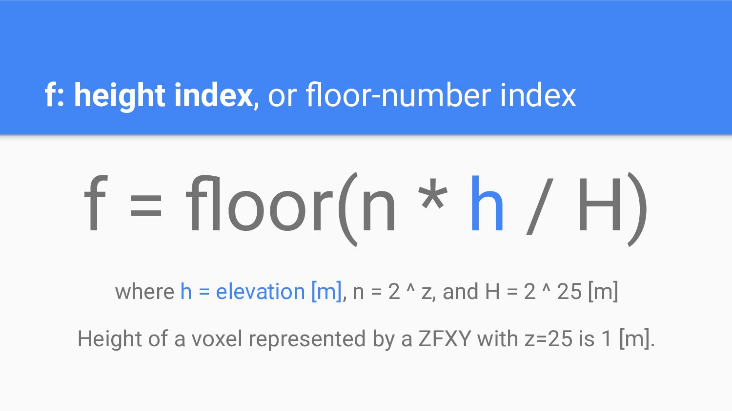
f: height index, or floor-number index f = floor(n *
h / H) where h = elevation [m], n = 2 ^ z, and H = 2 ^ 25 [m] Height of a voxel represented by a ZFXY with z=25 is 1 [m].
https://github.com/unvt/zfxy-spec
https://github.com/unvt/zfxy-ruby
Demo
https://unvt.github.io/zfxy-ruby/
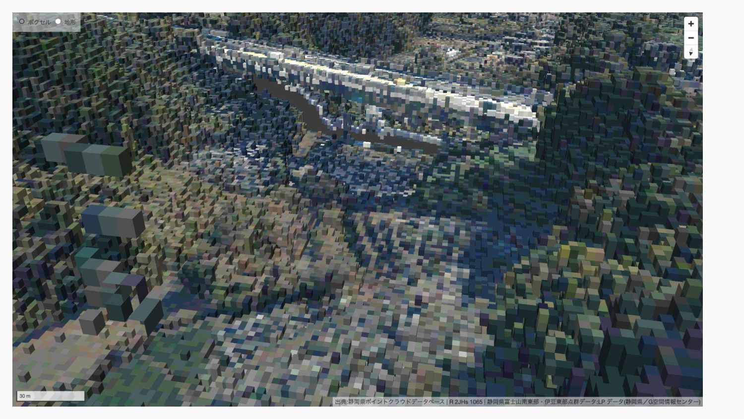
50cm GSD at z=26 https://x.optgeo.org/zfxy-ruby/#22.28/35.65779459/139.70209432/-85.5/60
https://geolonia.github.io/zfxy/#8.14/35.431/138.612/-45.6/60
https://github.com/geolonia/zfxy
Temporal extension
ZFXY: 3D extension to the tile-scheme {z}/{f}/{x}/{y}/{t} z: zoom index,
f: height index, x: west-east index, y: north-south index, t: temporal index
t: temporal index, or pomodoro code Time.now.to_i / 1800
Motivation of UNVT Community to join We need data to
prove the value of ZFXY. We are happy to build prototypes with your data.
None
None

 SiteGround - Reliable hosting with speed, security, and support you can count on.


 hfu
 shugo
 pei0804
 akhino
 gogutan
 ymotongpoo
 raspython3
 mkdev10
 bitkey
 pfn
 fespinoza
 ueponx
 yut0naga1_fa
 coloredviolet
 cassininazir
 chikuwait
 honzajavorek
 marcduiker
 lara
 stephenakadiri
 smashingmag
 lemiorhan
 aki_iinuma
 maltzj
 kristinabergwall1