Upgrade to Pro — share decks privately, control downloads, hide ads and more …

Simulation and parameter estimation in geophysics

Simulation and parameter estimation in geophysics

Lindsey Heagy, Dom Fournier, Seogi Kang, Craig Miller and the SimPEG Team

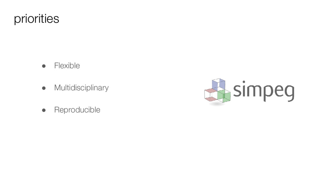
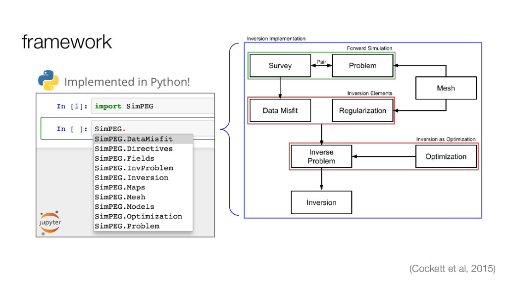
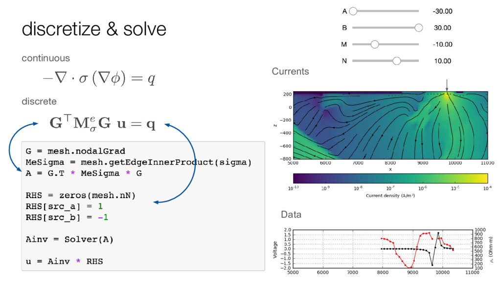
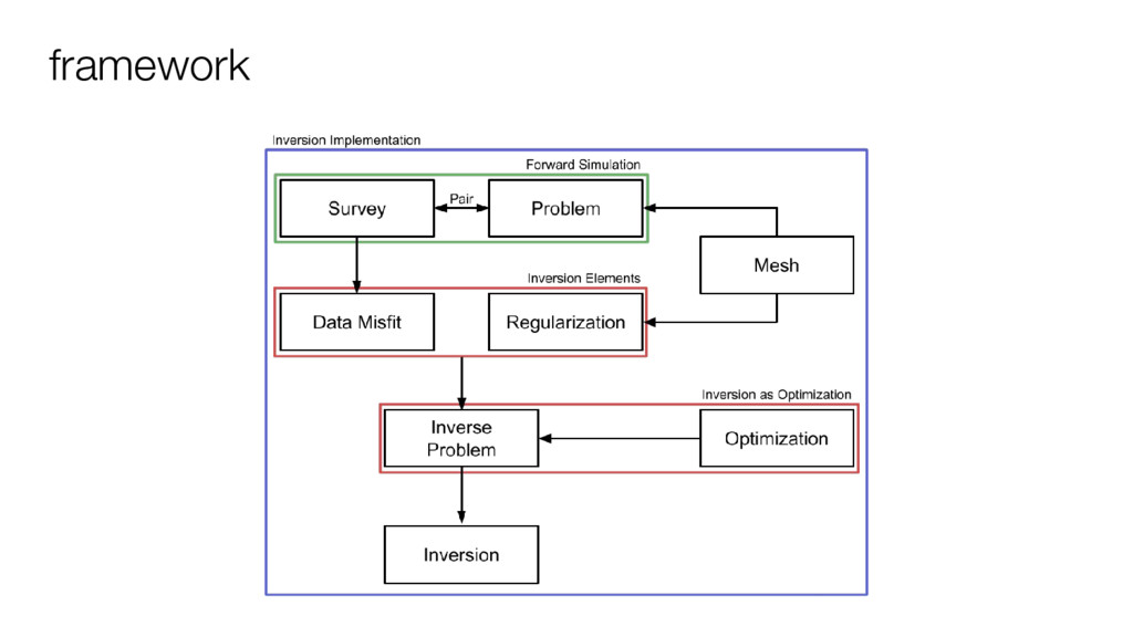
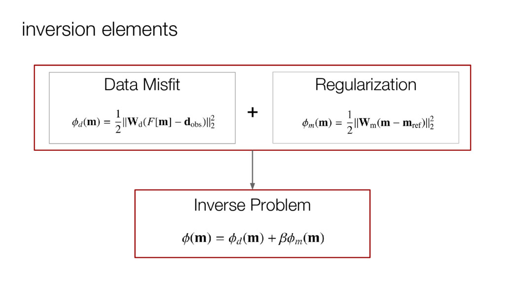
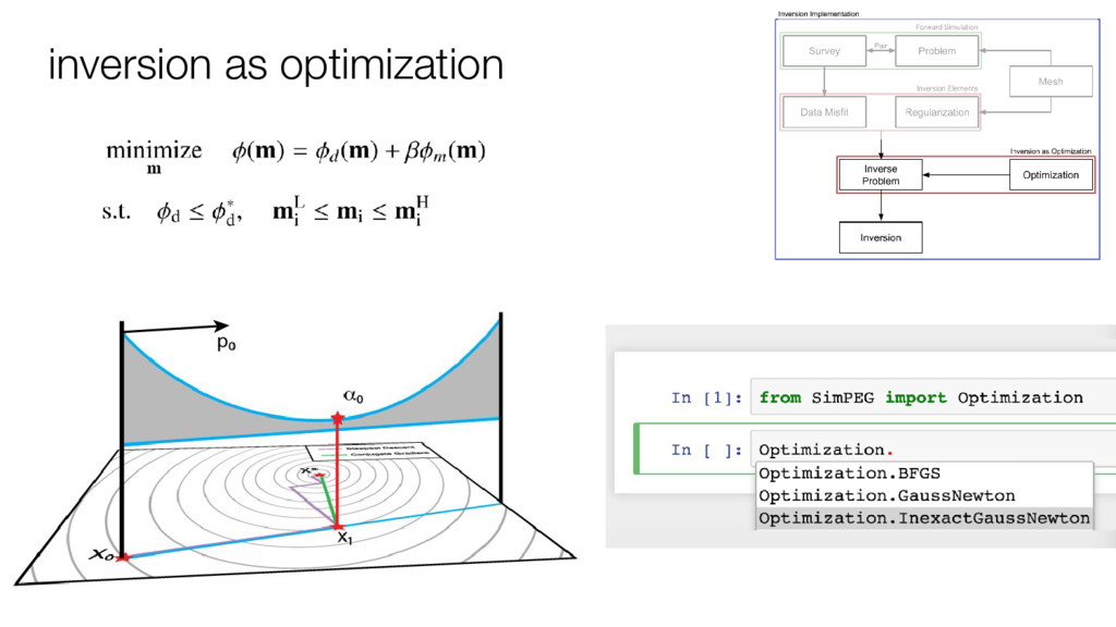
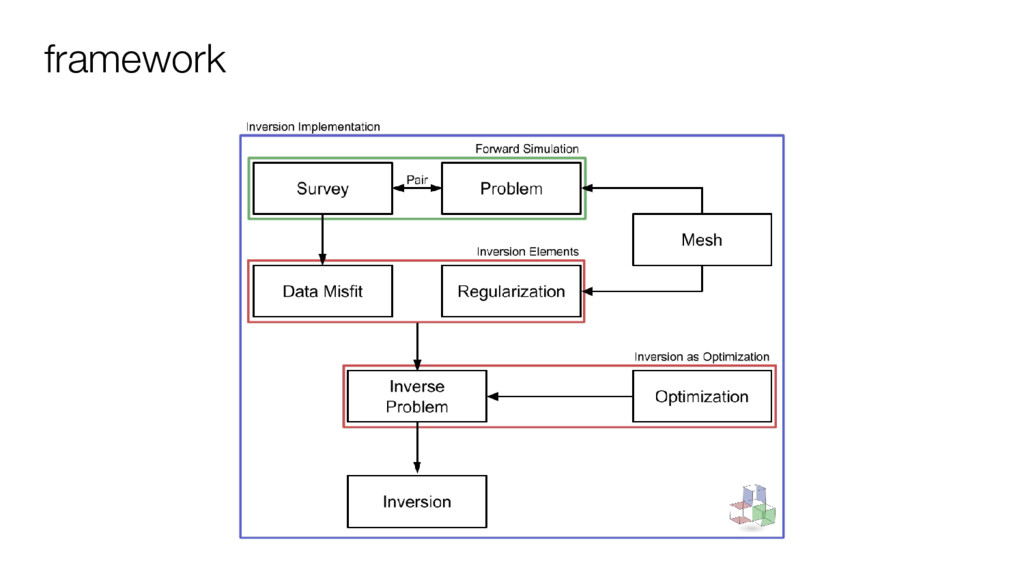
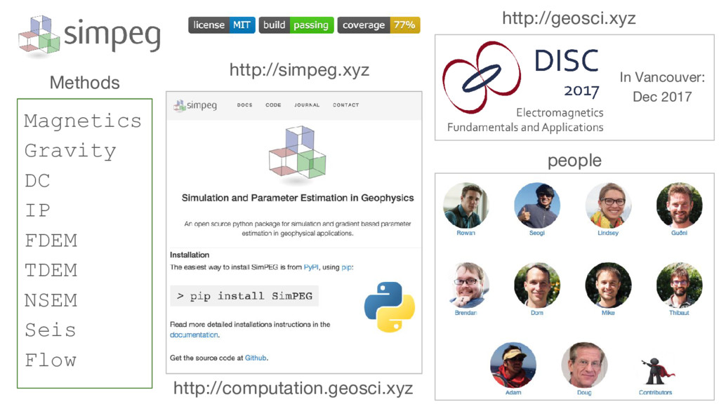
SimPEG (Simulation and Parameter Estimation in Geophysics, http://simpeg.xyz) is a collaborative effort to develop an open source framework for solving geophysical simulation and inversion problems, including electromagnetics, seismic and potential fields in a consistent manner. The goal in the development of SimPEG is to support a community of researchers with well-tested, extensible tools, and encourage transparency and reproducibility both of the SimPEG software and the geoscientific experiments.

Presented at the BC Geophysical Society meeting.

Lindsey Heagy

May 18, 2017
Tweet

More Decks by Lindsey Heagy

Other Decks in Science

Transcript

  1. • Motivated by integrated “Earth modeling” ◦ lithology + physical

    properties + structure • Use software that can handle ALL geophysics Discretize Case Study - Kevitsa Ni-Cu-PGE (Finland) PF.Grav(ρ) EM.Static(σ) EM.TDEM(σ) PF.Mag(К) Survey Simulation
  2. Case Study - Kevitsa Ni-Cu-PGE (Finland) • Previously owned First

    Quantum Minerals, acquired by Boliden (2016) • Disseminated mineralization within an olivine pyroxenite intrusion (dark grey) • 240 MT @ 0.3 Ni%, 0.4 Cu% FQM, (2011). 43-101 Technical Report Koivisto et al. (2015)
  3. Kevitsa Ni-Cu-PGE Bore logs (ρ, k, σ, η) EM: Conductivity

    Gravity: density Magnetics: Susceptibility • Multidisciplinary: ◦ 4 geophysical surveys ◦ 3 physical properties ◦ Borehole measurements
  4. Case Study - Kevitsa Ni-Cu-PGE (Finland) • 2D and 3D

    seismic data and interpreted contacts
  5. Case Study - Kevitsa Ni-Cu-PGE (Finland) • Simulating ALL geophysical

    responses Unit Density (ρ) Susc (k) Cond (σ) Mafic Volcanic Moderate Moderate Moderate Olivine Pyroxenite High Moderate Low Gabbro Moderate Low Low Carbonaceous Phyllite Low Low High Peridotite Moderate-low High Low Chloritic Volcanic Moderate-High Low Moderate Dunite Low High (Rem) Low Ore High? - High? Gabbro Koitelainen Moderate Low Low
  6. Potential Fields Simulation • How deep can PFs see? •

    Is the mineralization distinguishable? SimPEG.PF Unit Density (ρ) Susc (k) Cond (σ) Mafic Volcanic Moderate Moderate Moderate Olivine Pyroxenite High Moderate Low Gabbro Moderate Low Low Carbonaceous Phyllite Low Low High Peridotite Moderate-low High Low Chloritic Volcanic Moderate-High Low Moderate Dunite Low High (Rem) Low Ore High? - High? Gabbro Koitelainen Moderate Low Low
  7. Potential Fields: Density • Forward model gravity data (2 m

    height). Simplified model, but good enough to test the resolving power SimPEG.PF
  8. Potential Fields: Density • 3D Inversion: script available: Kevitsa_Grav_Inv.ipynb SimPEG.PF

    Good news! We can hope to see the lower limit of the intrusion. (Iso-surface 0.2 g/cc). But no sign of the mineralization ...
  9. Potential Fields Simulation • Simulated TMI data ◦ Large negatives

    in the center of the intrusive ◦ Well document remanence from the Dunite unit Induced and remanent magnetism study of Kevitsa SimPEG.PF
  10. Potential Fields Simulation • Simulated TMI data ◦ Quickly design

    a forward simulator and test remanence of the Dunite unit M Dunite unit likely larger and deeper than expected … time to invert. Montonen (2012) Msc. Thesis SimPEG.PF
  11. Potential Fields Simulation • Ongoing research: Efficient 3D-MVI ◦ Development

    of compact and robust inversion codes that can deal with remanence ◦ Magnetization mainly focussed in the Dunite and/or contact between the intrusion and the host stratigraphy. Likely extends at depth. ◦ Max depth resolution ~1,5 km SimPEG.PF
  12. Summary SimPEG.PF Unit Density (ρ) Susc (k) Cond (σ) Mafic

    Volcanic Moderate Moderate Moderate Olivine Pyroxenite High Moderate Low Gabbro Moderate Low Low Carbonaceous Phyllite Low Low High Peridotite Moderate-low High Low Chloritic Volcanic Moderate-High Low Moderate Dunite Low High (Rem) Low Ore High? - High? Gabbro Koitelainen Moderate Low Low • PF doesn’t see mineralization • What about conductivity?
  13. Electromagnetics - conductivity • Use DC and airborne EM ◦

    Conductivity contrasts ◦ DC: galvanic ◦ Airborne EM: inductive • DC ◦ Titan24 DC-IP survey (2007) ◦ Pole-dipole • Airborne EM ◦ VTEM (2009) ◦ Time domain / Co-located loop Depth at 90 m SimPEG.EM
  14. VTEM data 12150N Time decays VTEM at 198 micro-s Depth

    at 90 m Conductive Conductive? SimPEG.EM
  15. VTEM data 12150N Time decays VTEM at 198 micro-s Depth

    at 90 m SimPEG.EM Conductive Conductive?
  16. DC resistivity data DC pseudo-section at 12150N Depth at -130

    m VTEM at 198 micro-s SimPEG.EM Conductive Conductive
  17. Simulation: VTEM Waveform Layer (1D) Cylinder (3D) SimPEG.EM Question: What

    makes this difference b/w signals from 1D and 3D model?
  18. Summary: VTEM 12150N Field data: time decays VTEM at 198

    micro-s Synthetic data: time decays Physics: SimPEG.EM
  19. DC resistivity Field DC data: Pole-dipole (Titan24) Question: - Can

    we see conductive mineralized zones embedded at depth (~200 m) ? SimPEG.EM
  20. Kevitsa - Conclusion • What we have learned: ◦ Gravity

    modeling helped delineating the shape and extent of Kevitsa intrusion ◦ Magnetic modeling helped highlight the dunite and peridotite ◦ But not mineralized zones SimPEG.PF Gravity (density) Magnetic (susceptibility)
  21. Kevitsa - Conclusion • What we have learned: ◦ Airborne

    TEM survey can delineate sediment units, and has potential to detect conductive mineralized zone at depths ◦ DC survey can delineate conductive mineralized zones at depths SimPEG.EM Airborne EM: VTEM DC:Titan 24
  22. Following up: Laguna del Maule (Craig) • Gravity inversion of

    an active magma system • No geologic constraints, but using a mixed norm inversion to replicate a conceptual model SimPEG.PF
  23. Laguna del Maule, Chile, imaging a magma reservoir Largest region

    of rhyolite production in Andes: • > 70 eruptions since 25 ka • > 2 m uplift since 2007 • inflating sill at 5 km depth. SimPEG.PF
  24. Checkerboard test and initial L2 inversion Checkerboard test: • build

    model with GoCAD • simulate data • perform inversion • test how station distribution impacts ability to recover forward model Initial SimPEG inversion with L2 “smooth norm”. Not a lot of definition of edges. Next step a mixed norm inversion SimPEG.PF
  25. Compact inversion using mixed norm Create inversion scheme to fit

    our conceptions of a magma reservoir. • finite edges and a short gradational boundary to those edges. Mixed Lp norm inversion : • 0 p 2 • amplitudes ( ) • gradients ( ) of the model • use 0 (compact) on and 1 on . • 95th percentile for and SimPEG.PF Thermodynamic models (MELTS) to interpret density model in terms of melt, crystal and volatile proportions.
  26. Magma system image from gravity inversion High melt proportion, low

    density body (30 km3) enclosed with a larger (115 km3) high crystal content body. Cashman, Sparks and Blundy, Science 2017. SimPEG.PF
  27. Magnetics Gravity DC IP FDEM TDEM NSEM Seis Flow Methods

    http://simpeg.xyz people http://geosci.xyz In Vancouver: Dec 2017 http://computation.geosci.xyz