from the last geOcom ? Two major series in the middle: 2022.02 (geOrchestra v23.0) Released in Sep 2022 (2 minor releases included) 2023.01 (compatible with geOrchestra v23.0) Released in Apr 2023 (1 minor release included so far the next in June 2023) = Lots of new powerful updates! 30th - 31st of May 2023 - geOcom
https://docs.mapstore.geosolutionsgroup.com/en/v2023.01.01/user- guide/layer-settings/#styling-of-vector-layer • Support to WFS layers and imported vector layers (GeoJSON, Shapefile…) in 3D mode ◦ Visualization of 2D and 3D Geometries in 3D mode ◦ Support to Styling ◦ Support to Identify 30th - 31st of May 2023 - geOcom
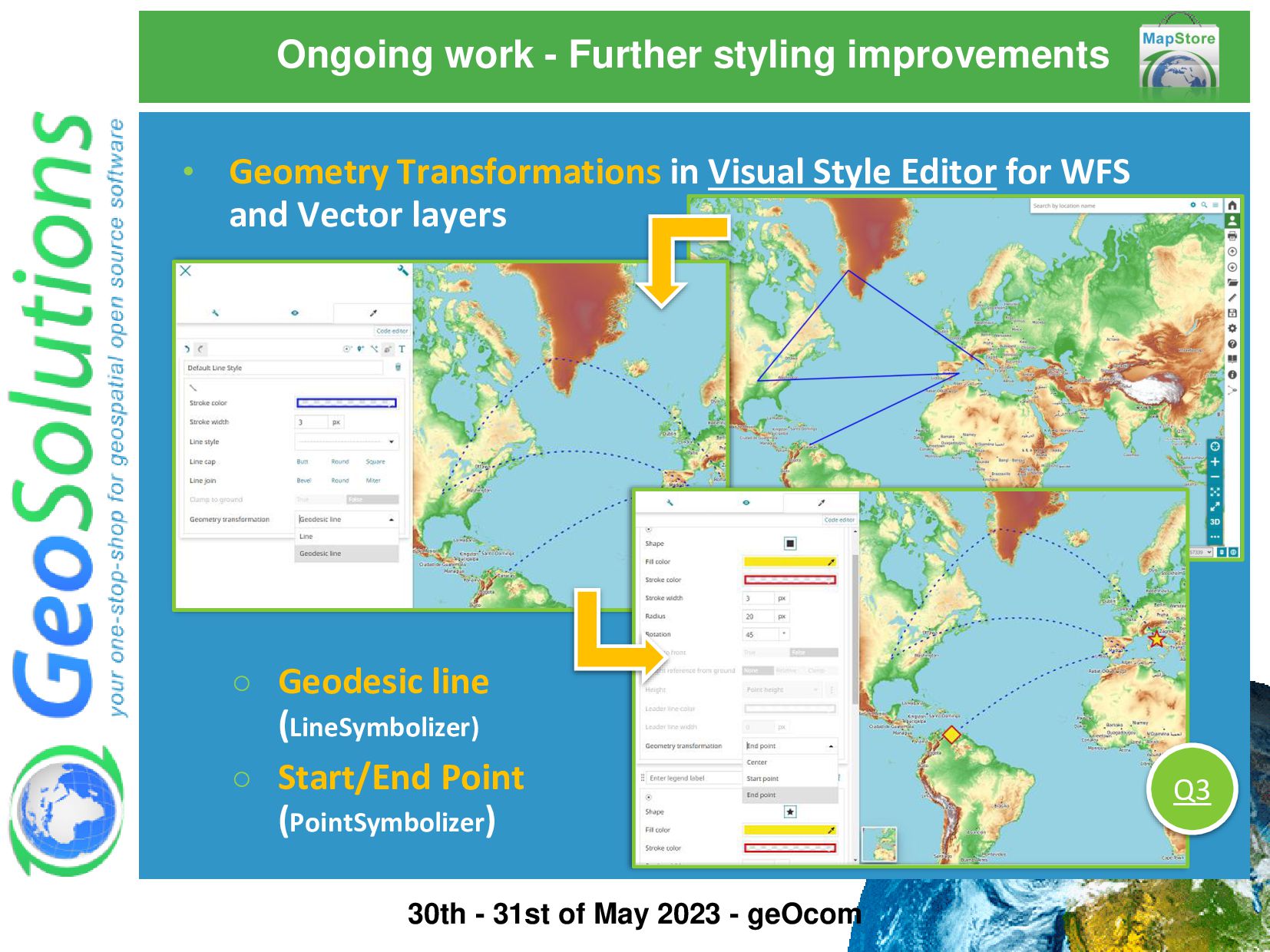
Polygons Normalized the UI/UX to be in line with the existing Visual Style Editor for WMS layers • Styling properties specific for 3D mode with the inclusion of dedicated symbolizers! 30th - 31st of May 2023 - geOcom
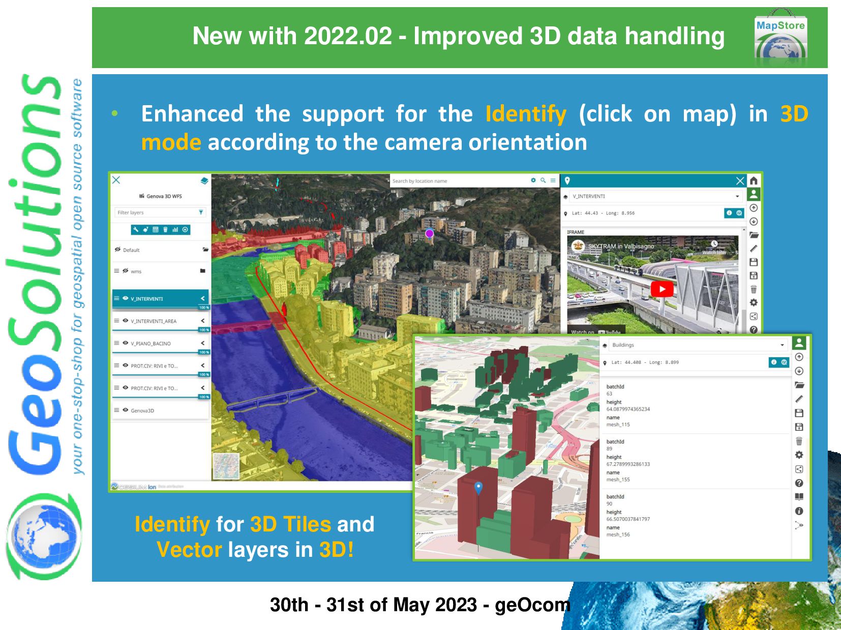
3D Tiles and Vector layers in 3D! • Enhanced the support for the Identify (click on map) in 3D mode according to the camera orientation 30th - 31st of May 2023 - geOcom
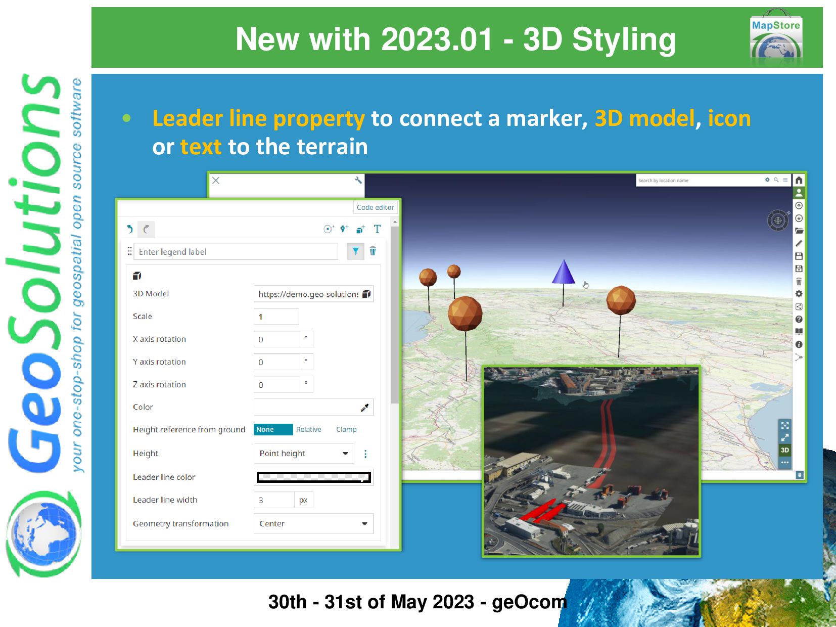
https://docs.mapstore.geosolutionsgroup.com/en/v2023.01.01/developer- guide/maps-configuration/#terrain Now you can configure the preferred Terrain provider for each 3D map! • Improved the support for Terrain layers including a new dedicated layer type to support terrain provider layer for the 3D viewer 30th - 31st of May 2023 - geOcom
Mb mapstore2.js 2.6 Mb • Further performance improvements from v2021.02 concerning the loading time of MapStore pages ◦ Reduced the initial MapStore JS bundle size by lazy-loading needed lib dependencies ◦ Modular Plugin: for a dynamic import of plugins and extensions only when lib dependencies are needed 30th - 31st of May 2023 - geOcom Thanks to Rennes Métropole & Co from geOrchestra ! ☺
A new design for the MapStore map viewer ◦ Faster and easier access to MapStore tools ◦ Allows concurrent use of multiple tools on the same map 30th - 31st of May 2023 - geOcom Thanks to Rennes Métropole & Co from geOrchestra ! ☺
in v2022.01.01 series ◦ Provided the ability to send query params using POST • Enhanced in v2022.02.00 ◦ Support to multiple embedded maps on the same web page via POST • Enhanced respectively in v2022.02.01 and v2022.02.02 ◦ Provided support for a simplified handling of query parameters ◦ Support of query params for 3D mode More documentation available online at: https://docs.mapstore.geosolutionsgroup.com/en/v2 023.01.01/developer-guide/map-query-parameters Example https://mapstore.geosolutionsgroup.com /mapstore/#/viewer/openlayers/new?ad dLayers=gs:us_states¢er=- 106.458,45.699&zoom=5&mapInfo=gs:us _states&mapInfoFilter=STATE_FIPS=30 30th - 31st of May 2023 - geOcom Thanks to Rennes Métropole & Co from geOrchestra ! ☺
of 2022 to provide a longitudinal profile visualization for MapStore in geOrchestra (based on the WPS provided by Le Puy en Velay) 30th - 31st of May 2023 - geOcom Thanks to Rennes Métropole & Co from geOrchestra ! ☺ New with 2022.02 - Longitudinal Profile Based on https://github.com/geosolutions-it/MapStoreExtension New! Check it out https://github.com/georchestra/mapstore2-longitudinal-profile
Check it out on Github https://github.com/geosolutions- it/MapStore2/releases/tag/v2023.01.00 https://github.com/geosolutions- it/MapStore2/releases/tag/v2023.01.01 30th - 31st of May 2023 - geOcom
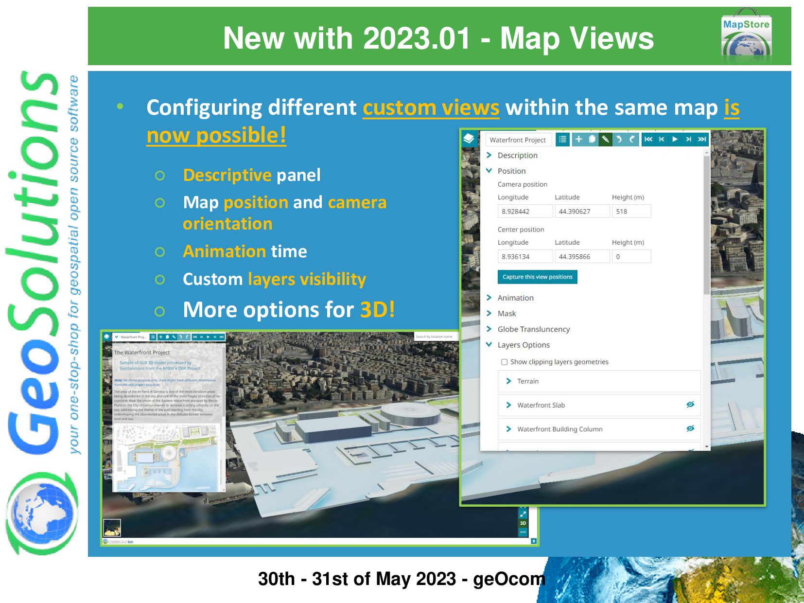
experience within the MapStore Viewer using the new powerful Views Tool! Check out the online documentation https://docs.mapstore.geosolutionsgroup.com/en/v2023.01.01/user-guide/map-views/ 30th - 31st of May 2023 - geOcom
views within the same map is now possible! ◦ Descriptive panel ◦ Map position and camera orientation ◦ Animation time ◦ Custom layers visibility ◦ More options for 3D! 30th - 31st of May 2023 - geOcom
options are available for the 3D mode Clip and Mask of 3D Tiles (using WFS or Vector features) Clipping of Terrain Layers Globe Translucency 30th - 31st of May 2023 - geOcom
is now supported also in 3D mode • Distance • Area • Point Coordinates • Height from terrain • Angle • Slope A completely new design provides a Measurement tool more compact and flexible to improve also the UX! 30th - 31st of May 2023 - geOcom
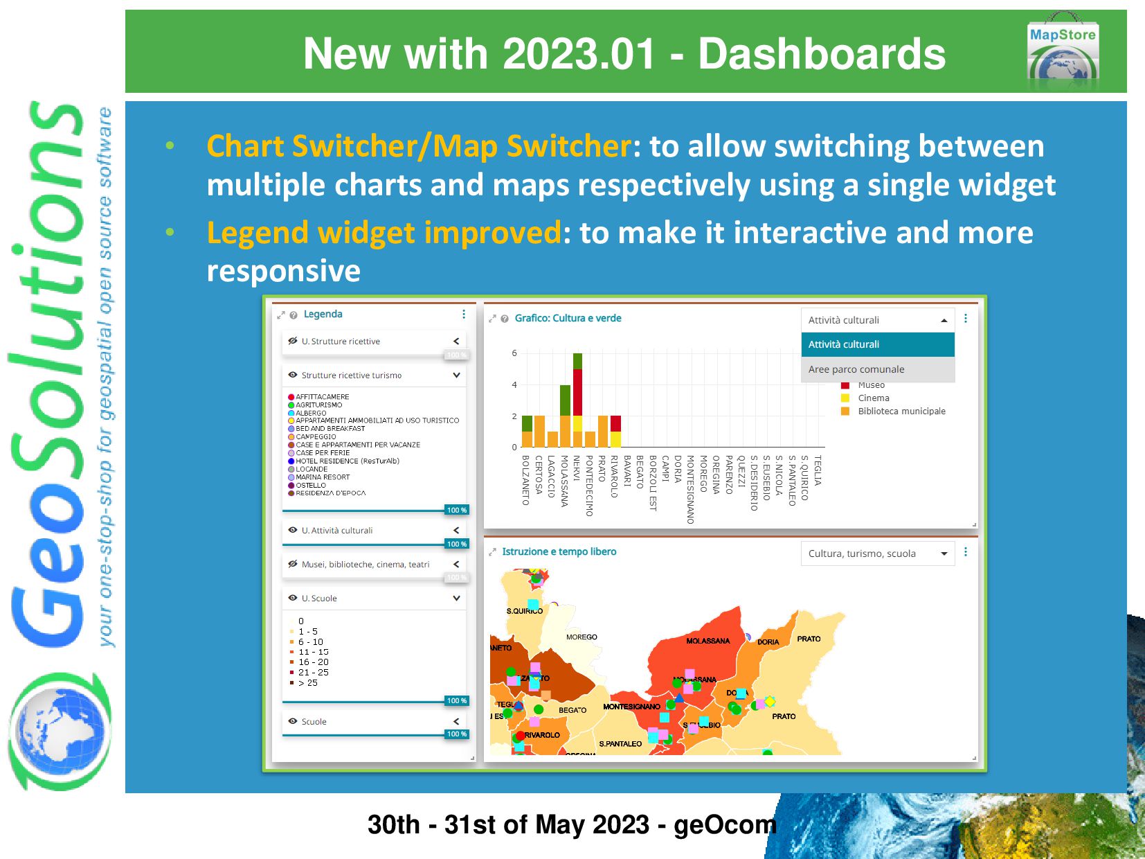
allow switching between multiple charts and maps respectively using a single widget • Legend widget improved: to make it interactive and more responsive 30th - 31st of May 2023 - geOcom
existing MapStore capabilities have been also included • Improved interoperability with services other than GeoServer (Server Type option and more) • … and allow to load 3D Tiles tilesets via query parameters (THANKS to CRAIG! ☺) • Filter by viewport in Attribute Table • Improved responsiveness for MS widgets in mobile • Ability to set domain sharding directly from the Catalog component • 3D zoom via share URL now supports the camera orientation • Client side customization for WMTS background layers attributions • ...and much more. Check out the releases page in Github to learn more! 30th - 31st of May 2023 - geOcom
working on some new interesting features that will land in MapStore and mapstore2-georchestra THIS YEAR! ☺ 30th - 31st of May 2023 - geOcom Thanks to Rennes Métropole & Co from geOrchestra ! ☺
The mapstore2-georchestra downstream project will be updated to the latest version of MapStore 2023.01.xx 30th - 31st of May 2023 - geOcom Q2 All new features of MapStore 2023.01 will be available in geOrchestra soon!
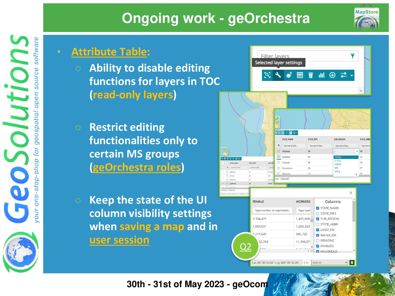
disable editing functions for layers in TOC (read-only layers) ◦ Restrict editing functionalities only to certain MS groups (geOrchestra roles) ◦ Keep the state of the UI column visibility settings when saving a map and in user session 30th - 31st of May 2023 - geOcom Q2
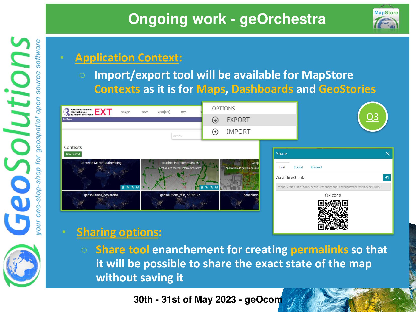
will be available for MapStore Contexts as it is for Maps, Dashboards and GeoStories 30th - 31st of May 2023 - geOcom Q3 • Sharing options: ◦ Share tool enanchement for creating permalinks so that it will be possible to share the exact state of the map without saving it
The support for a new source type will be included in MapStore Catalog tool … 30th - 31st of May 2023 - geOcom • Efficient Imagery Data Access: ◦ Only the data you need ◦ Improving scalability and reducing bottlenecks • Reduced Data Duplication: ◦ Data available online for all consumers … to be in line with many software already using it! Q4 • Many Providers: ◦ eg. S3, Google Cloud Storage, Azure
new features and improvements for existing and new tools to be available in next releases! The MapStore community is also growing a lot, Thank you all for using MapStore! ☺ 30th - 31st of May 2023 - geOcom
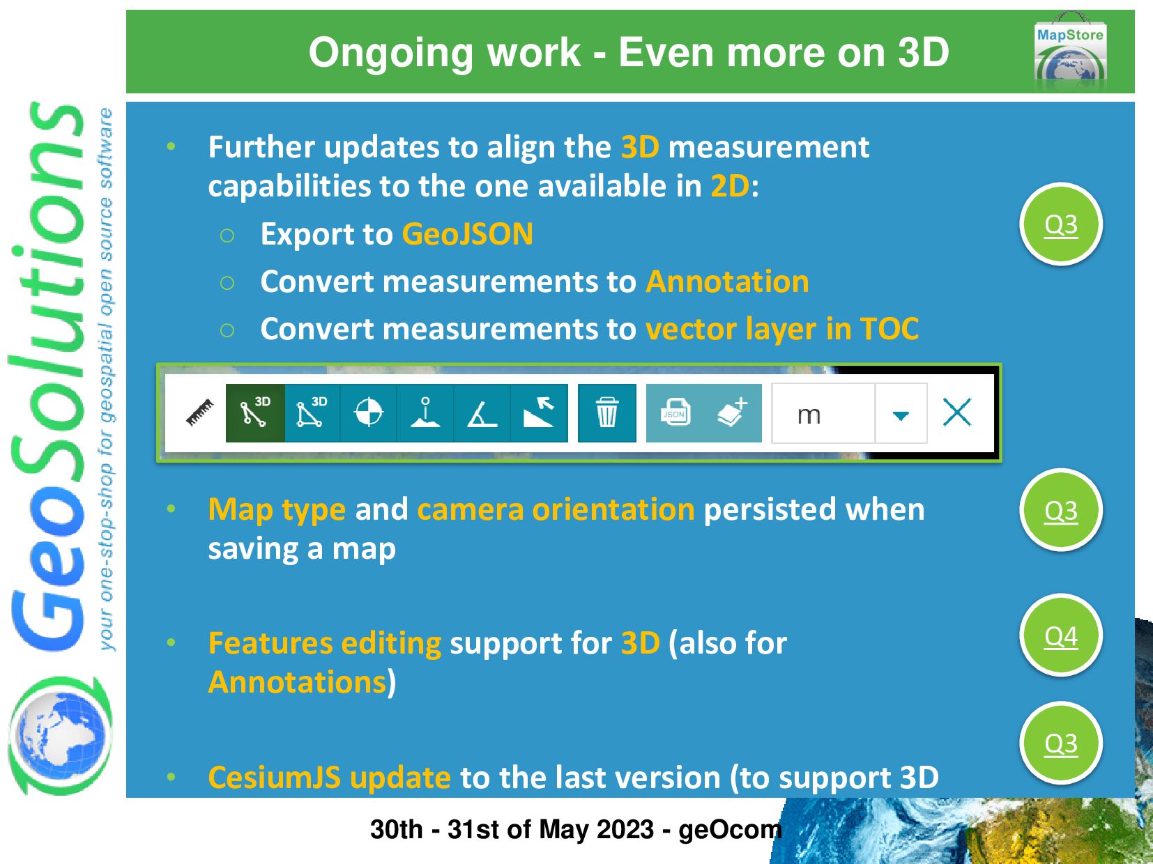
the one available in 2D: ◦ Export to GeoJSON ◦ Convert measurements to Annotation ◦ Convert measurements to vector layer in TOC • Map type and camera orientation persisted when saving a map • Features editing support for 3D (also for Annotations) • CesiumJS update to the last version (to support 3D Tiles version 1.1) Q3 Q3 Q4 Q3 30th - 31st of May 2023 - geOcom Ongoing work - Even more on 3D
available also in 3D mode! • Experimentation on possible performance improvements for Terrain layers rendering: ◦ BIL Terrain caching server side and GeoServer enhancements on DDS/BIL format ◦ Terrain layer served with static quantized-mesh Q3 Q4 30th - 31st of May 2023 - geOcom
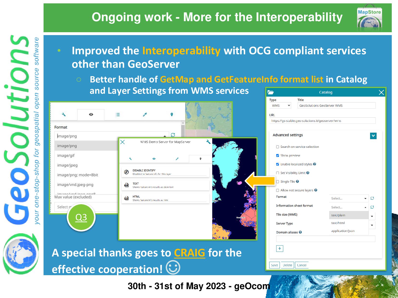
Interoperability with OCG compliant services other than GeoServer ◦ Better handle of GetMap and GetFeatureInfo format list in Catalog and Layer Settings from WMS services A special thanks goes to CRAIG for the effective cooperation! ☺ Q3 30th - 31st of May 2023 - geOcom
◦ Multiple variable charts ◦ Additional chart types ◦ More configuration options Enhancing the integration with PlotlyJS! Both Dashboard and MapViewer! Q4 30th - 31st of May 2023 - geOcom
3D Tiles: ongoing experiments on MapStore DEV are giving really good results with this! Keeping up with Google by using Map Tiles APIs with MapStore Still Experimental (Pre-GA Offerings) CesiumJS version updated to 1.91.0! Q3 Check it out! https://dev- mapstore.geosolutionsgroup.com/mapstore/#/context/ MapStorePhotorealistic3DTiles/44034 30th - 31st of May 2023 - geOcom
guides of the last MapStore release v2023.01.01 https://docs.mapstore.geosolutionsgroup.com/en/v 2023.01.01/user-guide/ https://docs.mapstore.geosolutionsgroup.com/en/v 2023.01.01/developer-guide/ 30th - 31st of May 2023 - geOcom
![That’s all folks! Questions? [email protected] 30th - 31st of May](https://files.speakerdeck.com/presentations/cefed3abeb8b4d8d9bfd493ffc77449c/slide_43.jpg)