Upgrade to Pro — share decks privately, control downloads, hide ads and more …

Hexagon Product Overview

Hexagon Product Overview

More Decks by Texas Natural Resources Information System

Other Decks in Technology

Transcript

  1. 2 AGENDA 01 02 Hexagon Overview (Intergraph/ERDAS/Leica) Complimentary Products -

    Hexagon Geospatial 03 Texas Enterprise License Agreement (ELA) Offer 04 05 Handouts Questions
  2. 3 2.4bn EUR turnover 8% long-term growth above 20% operating

    margin 11% of net sales invested in R&D Head offices in Stockholm and London Turnover of close to 2.4 billion EUR Shares listed on NASDAQ OMX Stockholm Hexagon is a leading global provider of information technologies that drive quality and productivity improvements across geospatial and industrial enterprise applications. Who is Hexagon? More than 14,000 employees in over 40 countries More than 3,000 employees engaged in R&D More than 3,200 active patents in patent portfolio above 20% operating margin
  3. 4 © 2012 Intergraph Corporation Global leader of visualization technologies

    - acquired Leica, ERDAS and Intergraph to accomplish Hexagon’s vision to become the world’s leading Geospatial Solutions provider. The enclosed product information supersedes any previous communications of the product direction, vision, future, features, or timelines.
  4. 8 Intergraph Geospatial Products Remote Sensing Data Intranet/Internet Users &

    Consumers Web Services Information Products Server GIS Desktop Data Field Mapping & Update Satellite Sensor Data Geo-Portals Photogrammetry Data Airborne Sensors Data Server Terrestrial Sensors Spatial Database GeoMedia ImageStation/LPS ArcGIS Extensions -Stereo analyst -Feature Assist -Terrain Editor ECW for ArcGIS ERDAS IMAGINE ER Mapper ERDAS APOLLO GeoMedia WebMap GeoMedia SDI GeoMedia Smart Client Mobile Mobile Map Works Mobile Alert
  5. 10 PRODUCER SUITE ERDAS IMAGINE GeoMedia ImageStation Collect, process, analyze

    and understand raw geospatial data, and ultimately deliver usable information.
  6. 11

  7. 12 ERDAS IMAGINE: Author Geospatial Information Reference your imagery to

    the earth’s surface Measure primary information from the imagery to collect vector, point, area and other quantitative data Analyze data to draw conclusions about the processes and activities affecting your area of study Update your GIS with accurate geospatial data Present and publish your imagery, geospatial information and geospatial processes in 2D and 3D environments
  8. 15 An integrated environment that lets you: - see your

    point cloud data in context of your GIS so that interactive updates of features can take place, namely •  Locate assets that are not in your GIS •  Locate assets that are in the incorrect location •  Locate assets that may be in need of repair Tuesday,  August  11,  15   Tweet about this presentation #gispro2014 15  
  9. 17 PROVIDER SUITE Easily store, discover, manage and deliver your

    data across desktop, web and mobile applications.
  10. 18

  11. 19 ERDAS APOLLO •  Comprehensive data management, analysis, and delivery

    system enabling an organization to describe, catalog, search, discover, process and securely disseminate massive volumes of data.
  12. 20 ERDAS APOLLO Workflow ERDAS APOLLO Catalog and Server Spatial

    Models: WPS Raster (TIFF, JPG200, etc..) Digital (PDF, WMV, DOC) 3rd Party OGC Services LiDAR Vector (Oracle, FGDB, GML) OGC Tile Cache ECWP File Data Management Catalog Security Services Style Analysis Feature Edits/Update Visualization
  13. 21 Solving the “Bounding Box” problem Given a bounding box

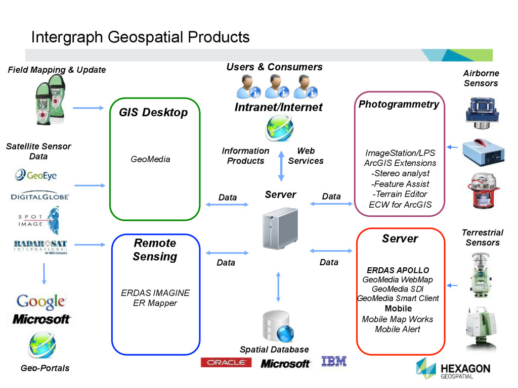
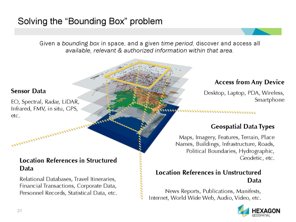
    in space, and a given time period, discover and access all available, relevant & authorized information within that area. Geospatial Data Types Maps, Imagery, Features, Terrain, Place Names, Buildings, Infrastructure, Roads, Political Boundaries, Hydrographic, Geodetic, etc. Location References in Structured Data Relational Databases, Travel Itineraries, Financial Transactions, Corporate Data, Personnel Records, Statistical Data, etc. Sensor Data EO, Spectral, Radar, LiDAR, Infrared, FMV, in situ, GPS, etc. Access from Any Device Desktop, Laptop, PDA, Wireless, Smartphone Location References in Unstructured Data News Reports, Publications, Manifests, Internet, World Wide Web, Audio, Video, etc.
  14. 22 PLATFORM SUITE Create your own unique application on top

    of a solid foundation of powerful geospatial functionality.
  15. 23

  16. 24 GeoMedia Smart Client ü  User-friendly and streamlined Field Inspection

    workflows ü  Workflows without custom code ü  Reduced training overhead ü  Connected or disconnected workflows ü  Increased information sharing/re-use ü  Lower software administration costs
  17. 25 GeoMedia Smart Client ü  User-friendly and streamlined Field Appraisal

    workflows ü  Workflows without custom code ü  Reduced training overhead ü  Connected or disconnected workflows ü  Increased information sharing/re-use ü  Lower software administration costs
  18. 26 26 OUR VALUE PROPOSITION FOR ASSESSORS: Change detection for

    assessment field visit – semi-automated process for identification of the top 20% of highest probability of change for re-assessment candidates site/field visit. Ability to see side-by-side; old imagery with current to see actual change (usually 2- year different flyovers). Assistance with the actual site visits to verify actual changes, reduce phone calls for challenges and hearings. Mobile field verification assistance – eliminates double entry after field visit (complete sketches in field). Reduce errors from translations at home office data entry (complete entries in the field). Geo-reference building sketches in both CAMA and GIS systems; keeping them in sync. Integrates with APEX, covering majority of building sketches and available CAMA systems.
  19. 28 GeoMedia  Smart  Client  -­‐  Architecture   Oracle Spatial /

    SDE Microsoft SQL Server / SDE MS Access MSTN Design Files Shape Files MS Excel Autodesk DWG OGC Bing, Google, Yahoo, Etc. Other Users Applications Application Server Data 0 Administrator Staff 0 Geospatial Server Workflow Implementer 0 Smart Client Administration Workflow Manager
  20. 29 What is Mobile MapWorks? – Product Description Intergraph’s Mobile

    MapWorks is a tablet-based, field inspection and editing app for enterprise GIS data.
  21. 30 What is Mobile Alert ?– Product Description Intergraph’s Mobile

    Alert is a cloud service that provides crowd- sourced incident information to subscribing organizations, e.g. local governments or utilities. Vandalism