Upgrade to Pro — share decks privately, control downloads, hide ads and more …

Introduction of Gyeong-in Ara Waterway for Multiple Purposes

WCC Scotland
September 19, 2016

Introduction of Gyeong-in Ara Waterway for Multiple Purposes

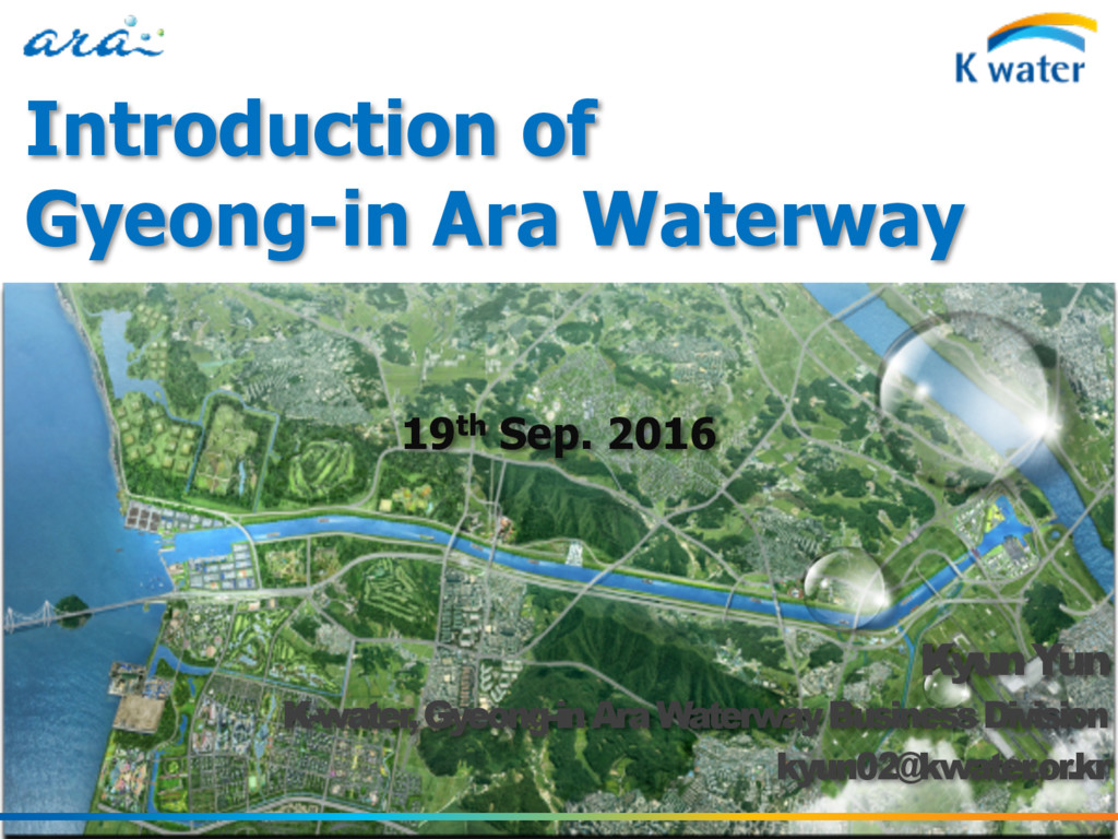
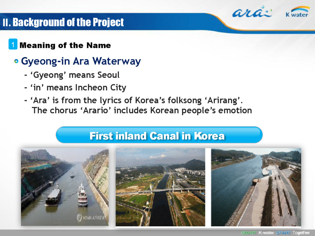
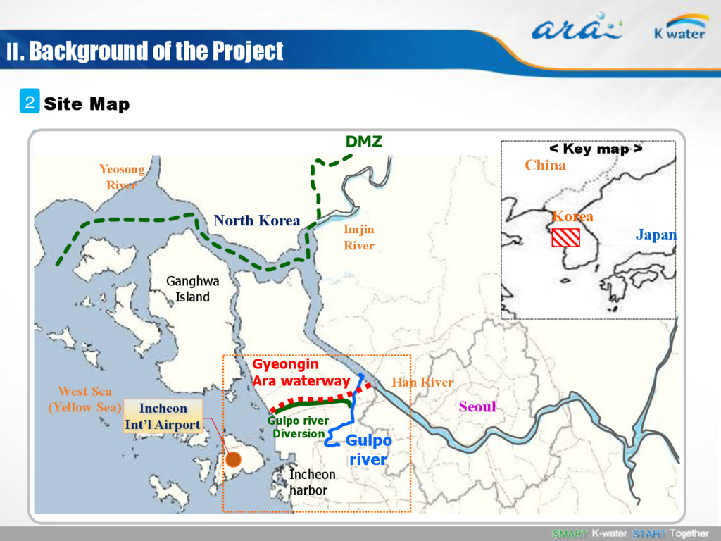
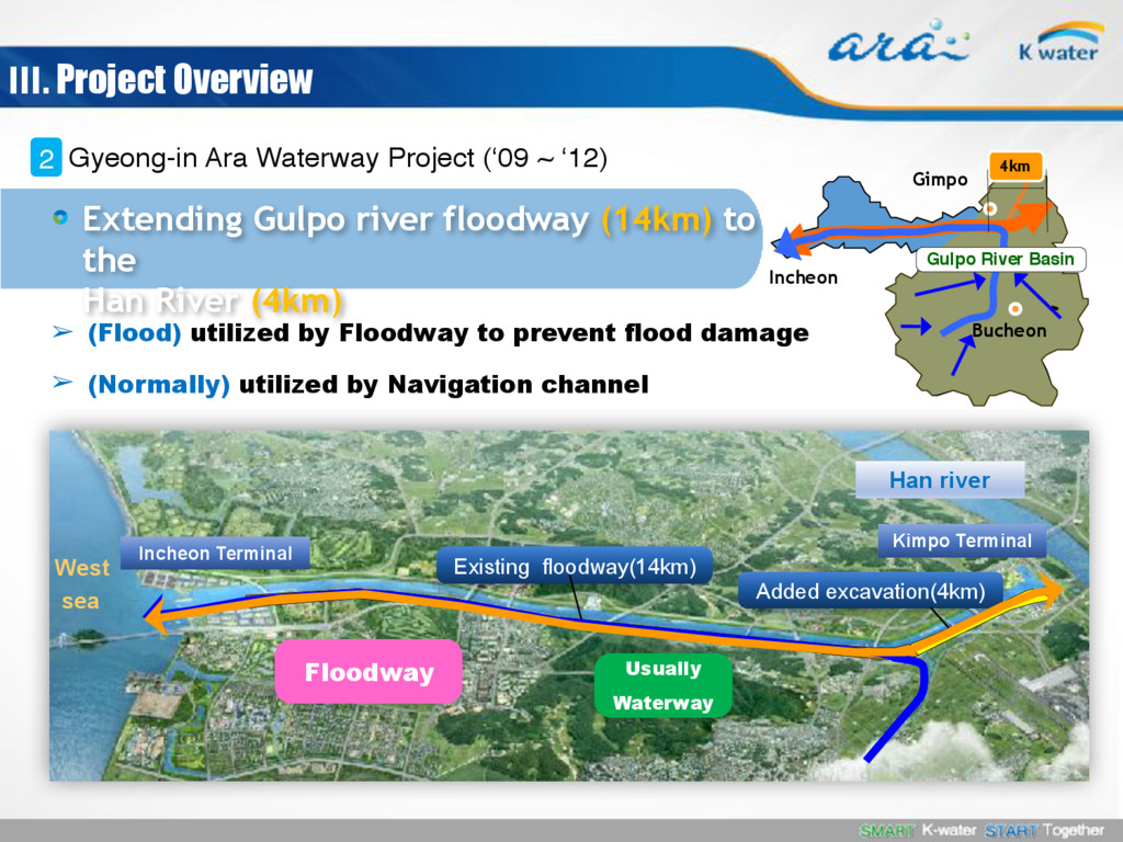
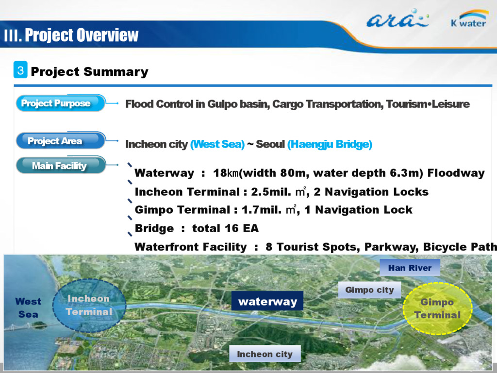
K-water, the only water-related solution provider in Korea, constructed the Gyeong-in Ara Waterway, the first in-land canal operating in Korea.

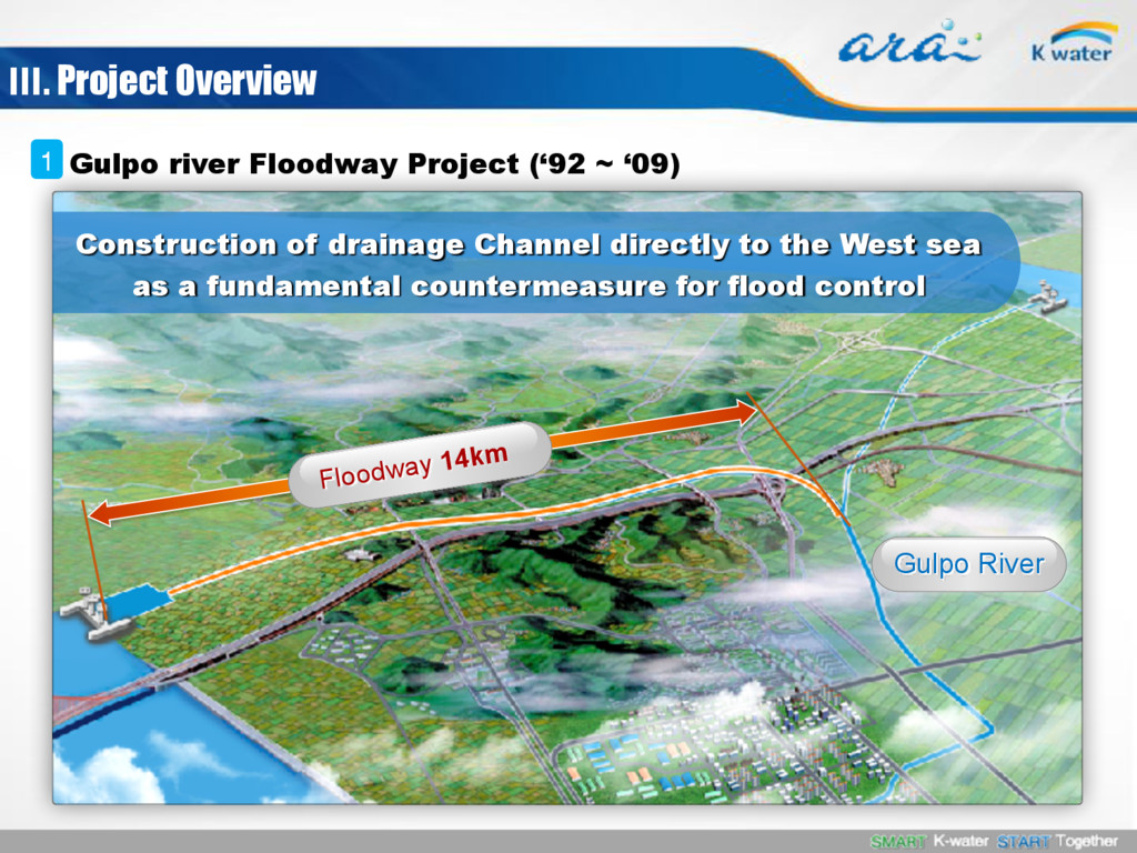
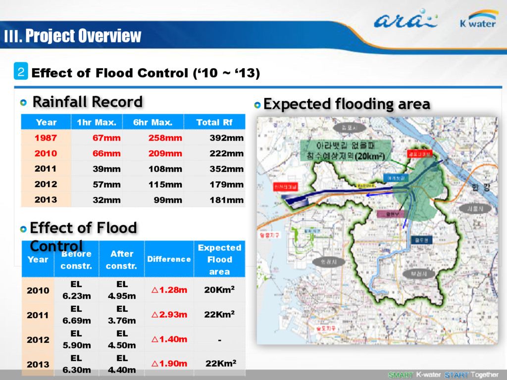
The Gyeong-in canal was originally designed to prevent the chronic flooding problem around the Gulpo River region, but was redesigned to serve as a flood prevention facility as well as a transport route. The goals of the project now include large vessel navigation to Seoul, flood damage protection in the Gulpo River basin, and contribution to the local economy through tourism, culture, and leisure.

WCC Scotland

September 19, 2016
Tweet

More Decks by WCC Scotland

Other Decks in Business

Transcript

  1. Introduction of Gyeong-in Ara Waterway 19th Sep. 2016 Kyun Yun

    K-water, Gyeong-in Ara Waterway Business Division kyun02@kwater .or .kr
  2. Table of Contents About K-water Ⅰ. Background of the Project

    Ⅱ. Project Overview Ⅲ. Current Status Ⅳ. In the Future Ⅴ.
  3. Overseas Projects Waterfront Cities & Industrial Clusters Water Resources Clean

    Energy Water Supply And sewage Total Water Service Provider A major water-managing public corporation in Korea with a history of fifty years of water management Established as the Korea Water Resources Development Corporation. (Nov. 16, 1967) Changed the company name into the Korea Water Resources Corporation. (Jul. 01, 1988) Ⅰ. About K-water
  4. Gyeong-in Ara Waterway - ‘Gyeong’ means Seoul - ‘in’ means

    Incheon City - ‘Ara’ is from the lyrics of Korea’s folksong ‘Arirang’. The chorus ‘Arario’ includes Korean people’s emotion Ⅱ. Background of the Project Meaning of the Name 1 First inland Canal in Korea
  5. Ganghwa Island Gulpo river Diversion Incheon harbor West Sea (Yellow

    Sea) Yeosong River Seoul Imjin River Han River DMZ Gyeongin Ara waterway Gulpo river China Korea Japan < Key map > North Korea Site Map 2 Incheon Int’l Airport Ⅱ. Background of the Project
  6. • Administrative District Incheon, Gimpo, Bucheon, Seoul city • Basin

    area 134㎢ • River Length 21㎞ • Population 1.5 million Gimpo city Seoul city Bucheon city Incheon city West Sea Incheon Int’l Airport Gyeong-in Ara Waterway Incheon terminal Gulpo-River Han river Historical Description 3 Flood Disaster(1987) (38 ㎢ inundated) Ⅱ. Background of the Project
  7. Han River 10.6m inundation 40% of Basin below EL.10m Average

    Level EL. 21.5m Gulpo River 6.5m Sea 0m Natural drainage(difficult) Historical Description 3 Gulpo basin area was inundated frequently because of low land Ⅱ. Background of the Project
  8. Floodway 14km Gulpo River Ⅲ. Project Overview Gulpo river Floodway

    Project (‘92 ~ ‘09) 1 Construction of drainage Channel directly to the West sea as a fundamental countermeasure for flood control
  9. Year 1hr Max. 6hr Max. Total Rf 1987 67mm 258mm

    392mm 2010 66mm 209mm 222mm 2011 39mm 108mm 352mm 2012 57mm 115mm 179mm 2013 32mm 99mm 181mm Year Before constr. After constr. Difference Expected Flood area 2010 EL 6.23m EL 4.95m △1.28m 20Km2 2011 EL 6.69m EL 3.76m △2.93m 22Km2 2012 EL 5.90m EL 4.50m △1.40m - 2013 EL 6.30m EL 4.40m △1.90m 22Km2 Effect of Flood Control (‘10 ~ ‘13) 2 Rainfall Record Effect of Flood Control Expected flooding area Ⅲ. Project Overview
  10. West sea Incheon Terminal Kimpo Terminal ➢ (Flood) utilized by

    Floodway to prevent flood damage ➢ (Normally) utilized by Navigation channel Existing floodway(14km) Added excavation(4km) Floodway Usually Waterway Bucheon ӣನ Gulpo River Basin Gimpo 4km Incheon Extending Gulpo river floodway (14km) to the Han River (4km) Han river Gyeong-in Ara Waterway Project (‘09 ~ ‘12) 2 Ⅲ. Project Overview
  11. Flood Control in Gulpo basin, Cargo Transportation, Tourism•Leisure Incheon city

    (West Sea) ~ Seoul (Haengju Bridge) Waterway : 18㎞(width 80m, water depth 6.3m) Floodway Incheon Terminal : 2.5mil. ㎡, 2 Navigation Locks Gimpo Terminal : 1.7mil. ㎡, 1 Navigation Lock Bridge : total 16 EA Waterfront Facility : 8 Tourist Spots, Parkway, Bicycle Path etc. ೠ ъ waterway West Sea Han River Gimpo city Incheon Terminal Gimpo Terminal Incheon city Project Summary 3 Project Purpose Project Area Main Facility Ⅲ. Project Overview
  12. Ship Intersecting Clearance Cross Section 6.3m (Vessel traffic condition) L

    18km, W 80m, Depth 6.3m, Clearance 16m (Target vessel) L 120m, B 16m, Depth 4.5m, 244TEU, 10knot Traffic conditions Additional excavation of 1.6m Navigation Channel 4 Ⅲ. Project Overview
  13. (View 1) The West Sea (future plan) (View 2) Incheon

    T/M (View 3) Sicheon Bridge Waterfront (View 4) Riverside Ara Waterfall (View 5) Gyulhyeon Bridge Waterfront (View 6) Dumulmeori Eco-Park (View 7) Gimpo T/M (View 8) Han River (future plan) View 1 View 2 View 3 View 4 View 5 View 6 View 7 View 8 (View 8) 8 Beautiful spaces along the waterway (Parkway) 15.6km two-lane road along the riverside (Bicycle Path) 41km, Official starting point of cross-country trip(633km) Waterfront Facility 7 Ⅲ. Project Overview
  14. Gyeong-In Domestic Jeju Busan Domestic Liner Service to Jeju by

    General cargo ship International Liner Service to China by Container ship Liner Service 1 Ⅳ. Current Status Dandong Shanghai Japan Southeast Asia Tianjin Qingdao Gyeong-In International
  15. (Cargo) Handling volume 2.2 million tons by 25 service routes

    - (Container) 1.6 million tons, (General cargo) 0.6 million tons (Passenger) 0.4 million people by 9 Cruise ships Performance by 2015 2 Ⅳ. Current Status