Upgrade to Pro — share decks privately, control downloads, hide ads and more …

政府オープンソース文化の地理院での進捗

 政府オープンソース文化の地理院での進捗

Presentation at Code for Japan Summit 2015
2015-11-07 "How to build open source culture inside government"

Hidenori FUJIMURA

November 07, 2015
Tweet

More Decks by Hidenori FUJIMURA

Other Decks in Technology

Transcript

  1. Ministry of Land, Infrastructure, Transport and Tourism Geospatial Information Authority

    of Japan 政府オープンソース文化の 地理院での進捗 Government open source in GSI 国土地理院情報普及課 藤村 英範 1 2015-11-07 14:40-16:10 Code for Japan Summit 2015 “How to build open source culture inside government” Slides available at speakerdeck.com/hfu
  2. 3つの施策と3つの技術 3 地理院タイルの活用を推進するための3つの施策 ①Open Data 政府戦略に基づき使いやすく提供する ②Open Source オープンソースを利用し、提供する ③Open

    Innovation    産学官連携を積極活用し、イノベーティブな成果を追求する 地理院地図の今後を方向付ける3つの技術 ①Elevation tiles 標高・地形が当たり前に分かるように ②Vector tiles 多様な表現と情報処理を可能に ③Digital Fabrication  新しいものづくりの技術を活用し、ニーズに合わせてものをつくる
  3. Our repos in GitHub 5 gsimaps source code of GSI

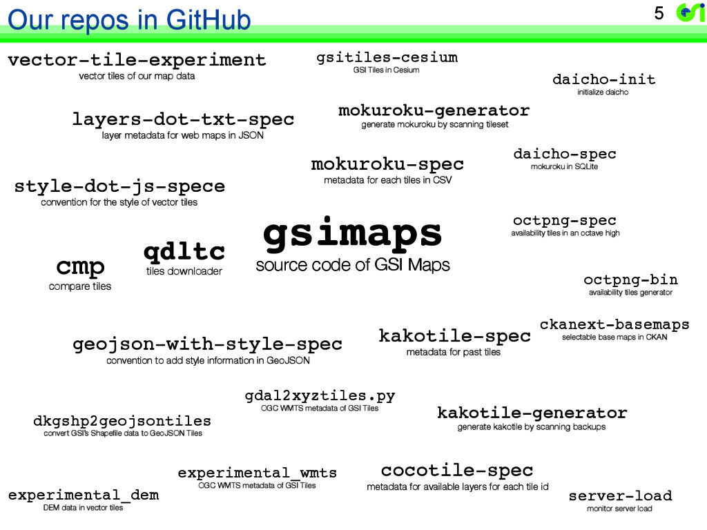
    Maps cmp compare tiles experimental_dem DEM data in vector tiles layers-dot-txt-spec layer metadata for web maps in JSON experimental_wmts OGC WMTS metadata of GSI Tiles kakotile-spec metadata for past tiles cocotile-spec metadata for available layers for each tile id mokuroku-spec metadata for each tiles in CSV mokuroku-generator generate mokuroku by scanning tileset kakotile-generator generate kakotile by scanning backups dkgshp2geojsontiles convert GSI’s Shapefile data to GeoJSON Tiles octpng-spec availability tiles in an octave high octpng-bin availability tiles generator daicho-spec mokuroku in SQLite daicho-init initialize daicho qdltc tiles downloader server-load monitor server load vector-tile-experiment vector tiles of our map data gsitiles-cesium GSI Tiles in Cesium geojson-with-style-spec convention to add style information in GeoJSON gdal2xyztiles.py OGC WMTS metadata of GSI Tiles style-dot-js-spece convention for the style of vector tiles ckanext-basemaps selectable base maps in CKAN
  4. なぜオープンソースなのか。地理院地図の場合 職務に忠実であろうとすれば、自然にオープンソースになった。 Open source was almost coded in the code;

    survey act, NSDI act, etc. –  測量法 第27条第2項 •  …地図その他一般の利用に供することが必要と認められるものについては 、これらを…不特定多数の者が提供を受けることができる状態に置く措置を とらなければならない。 →データを提供せよ –  地理空間情報活用推進基本法 第3条第6項 •  地理空間情報の活用の推進に関する施策は、地理空間情報を活用した多 様なサービスの提供が実現されることを通じて、国民の利便性の向上に寄 与するものでなければならない。→多様なサービスが実現される社会を作れ –  政府オープンデータ戦略 <実装> (1) 本業としてオープンデータ「地理院タイル」の配信を行え (2) 地理院タイルのショーケースとして「地理院地図」を作れ (3) 多様なサービスが多様な主体により実装される環境を作れ (4) 国民の利便性の向上を目的とせよ 7 オープンソース
  5. 速度の課題の解決 → 再発明ではなく評価 13 Evaluate existing encoding, do not re-invent one. Concentrate

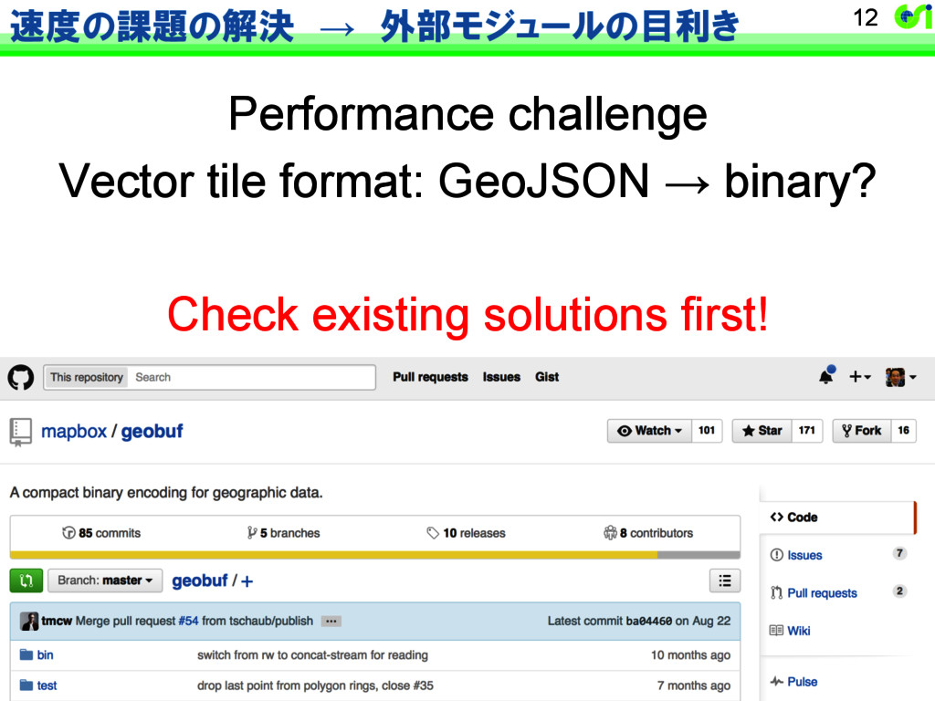
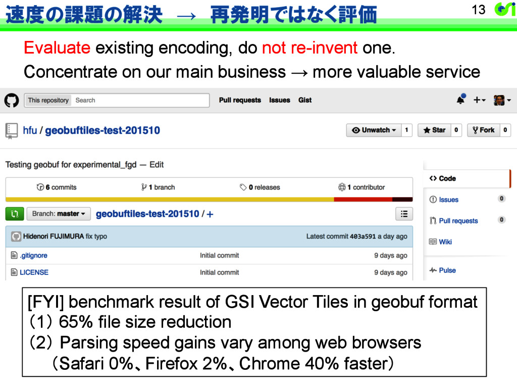
    on our main business → more valuable service [FYI] benchmark result of GSI Vector Tiles in geobuf format (1) 65% file size reduction (2) Parsing speed gains vary among web browsers   (Safari 0%、Firefox 2%、Chrome 40% faster)
  6. “My GSI Maps” The whole hands-on process is done on

    github.com (no git, no Desktop) ①  Fork gsimaps (gh-pages) ②  Take care of your GeoJSON ③  Add style.js and edit layers.txt ④  And you’re done! 15
  7. ソフトウェアの fork, pull request and merge 16 fork 成功例: 被災前後比較サイトでの

    IE9以降対応 pull request merge ソフトウェアの分身を作る 分身の側で進めた改善を 分身元でも反映することを 求める 分身元の方で、 求められた反映を 実施する
  8. Repo. 25 発 注 者 受 注 者 仕様 納品

    Repo. fork download pull request pull request pull request merge merge merge t
  9. Repo. 並行運用も当たり前 26 Repo. fork pull request pull request pull

    request merge merge merge Repo. test deploy pull request test deploy fork merge pull request merge t
  10. 27 Already in progress from Q3 2015 (1)地理院地図サーバ環境改良業務  (提供するタイルをオブジェクトストレージに格納、高速アップロードを実現) (2)地理院地図内部API改良業務

     (小さなAPIに切り分けた動的機能を、コンテナ(Docker)に移行) (3)地理院地図改良業務  (全般的なクライアントサイド性能向上、3D機能等の完全クライアントサイド化) (4)基盤地図情報等ベクトルタイル変換システム構築業務 (地形図の迅速更新に追従できるスピードで高速にベクトルタイル変換)