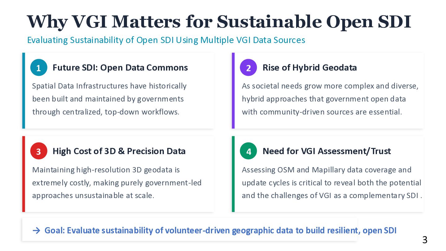
Open SDI Using Multiple VGI Data Sources 1 Future SDI: Open Data Commons Spatial Data Infrastructures have historically been built and maintained by governments through centralized, top-down workflows. 2 Rise of Hybrid Geodata As societal needs grow more complex and diverse, hybrid approaches that government open data with community-driven sources are essential. 3 High Cost of 3D & Precision Data Maintaining high-resolution 3D geodata is extremely costly, making purely government-led approaches unsustainable at scale. 4 Need for VGI Assessment/Trust Assessing OSM and Mapillary data coverage and update cycles is critical to reveal both the potential and the challenges of VGI as a complementary SDI . → Goal: Evaluate sustainability of volunteer-driven geographic data to build resilient, open SDI 3
City Models: Connecting the Dots 2019 OSM-Notes Quality feedback via user-posted Notes 2022 Mapillary + OSM edit Street imagery as road data catalyst 2024 OSM Changeset analyze Editing validation & Contributor action 2025 3D Attributes @ OSM Building 3D coverage on OSM Overarching Theme: VGI Activity Sustainability • Data Commons: How to evaluate, maintain, and improve the sustainability of volunteer-driven geographic data. • From individual OSM-Notes to large-scale 3D building analysis — multiple scales of assessment. • Emerging challenges: AI-assisted mapping, data imports, contributor concentration, regional inequality. 3D Library Performance Evaluation JS library + 3D Tile service 2023 Corroborative OSM and PLATEAU Overview PLATEAU and compare with central Tokyo data 4
Mapper, it is undeniable that it may contain a certain number of errors due to non-training. However, not all edits by New Mapper are suspect. →Currently, extend the analysis to over the past five years, we are analyzing 740,000 log data within Japan. Regional Distribution & Editor Concentration “suspicious” changesets coverage Percentage of reasons based on OSMCha’s detection rules Key Finding 6
where Si represents the distribute share (%) of editors i • Maximum value: 10,000 • >2,500: high concentration Building 3D Attribute Coverage and Spatial Disparity of Edit OSM 20th International 3D GeoInfo Conference 2025: https://doi.org/10.5194/isprs-archives-XLVIII-4-W15-2025-149-2025 Study Scope All Japan (47 prefectures, 1,905 cities) OSM data 24.2M buildings, 24,394 contributors (editors) Target 3D Attributes 4.7% Height coverage HHI 2,075 Avg. of HHI editor concentration Other attributes: 0.002-4.6% •height; 1,125,395 buildings (4.7%) •building:levels; 1,104,648 buildings (4.6%) •min_height; •ele •building:levels:underground 7
3D Attribute Coverage by Prefecture Contributors Count by Pref. Key Finding Building count correlates with contributors (r=0.608), but height coverage does not (r=0.256). HHI >2,500: high 8
Data as Open Digital Commons FOSS4G 2023 Academic Track: https://doi.org/10.5194/isprs-archives-XLVIII-4-W7-2023-201-2023 Project PLATEAU 2020-2022’s datasets 3D CityGML models, 150+ cities 18.3M+ buildings (LOD1/LOD2) PLATEAU vs OSM OSM covers ~31% of PLATEAU in target cities Tokyo: OSM ~40% of PLATEAU objects 502 blocks where OSM exceeds PLATEAU FOSS4G Tools usage and new developments PLATEAU VIEW (Re:Earth) 16 open-source repositories on GitHub (2022) → Now: 140+ repositories 9
Building Model (LOD2) OSM Buildings include “3D attributes” 10 Key Insights 3,190 city blocks in Tokyo analyzed. 1,548 blocks: OSM < 50% of PLATEAU. 502 blocks: OSM exceeds PLATEAU. Continuous updating and wider government coverage remain key challenges . → Integrate PLATEAU data into OSM is ongoing based on community consensus.
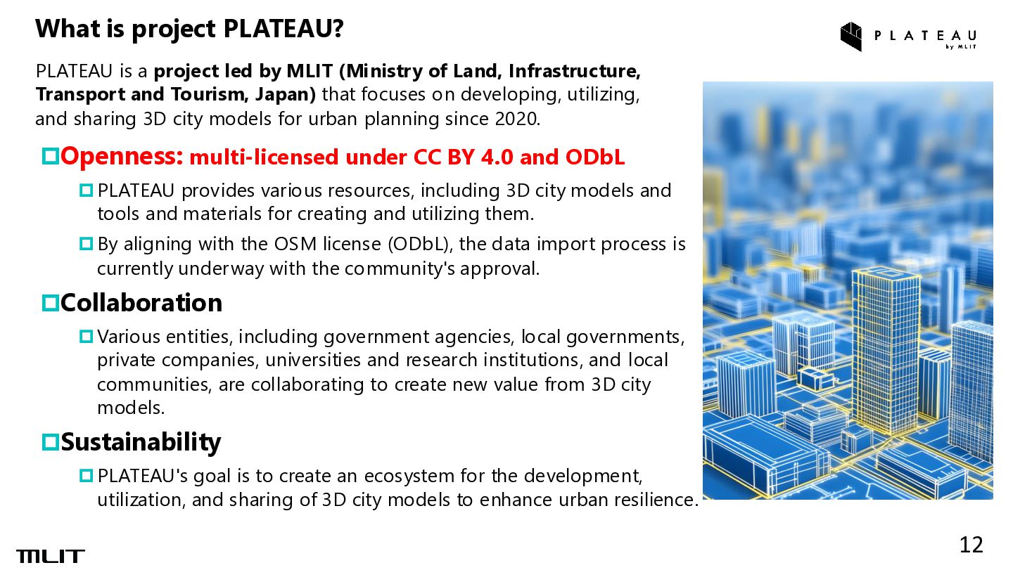
provides various resources, including 3D city models and tools and materials for creating and utilizing them. By aligning with the OSM license (ODbL), the data import process is currently underway with the community's approval. Collaboration Various entities, including government agencies, local governments, private companies, universities and research institutions, and local communities, are collaborating to create new value from 3D city models. Sustainability PLATEAU's goal is to create an ecosystem for the development, utilization, and sharing of 3D city models to enhance urban resilience. PLATEAU is a project led by MLIT (Ministry of Land, Infrastructure, Transport and Tourism, Japan) that focuses on developing, utilizing, and sharing 3D city models for urban planning since 2020. What is project PLATEAU? 12
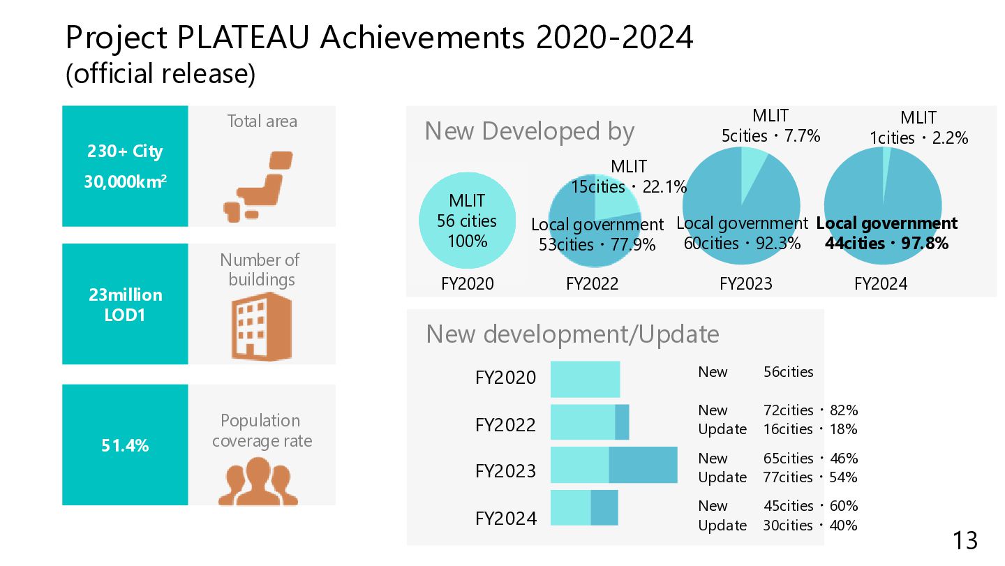
FY2023 FY2024 New 56cities New 72cities・82% Update 16cities・18% New 65cities・46% Update 77cities・54% Number of buildings Total area Population coverage rate 51.4% 23million LOD1 230+ City 30,000km2 New Developed by MLIT 5cities・7.7% Local government 60cities・92.3% MLIT 56 cities 100% FY2023 FY2020 MLIT 15cities・22.1% Local government 53cities・77.9% FY2022 MLIT 1cities・2.2% Local government 44cities・97.8% FY2024 New 45cities・60% Update 30cities・40% 13
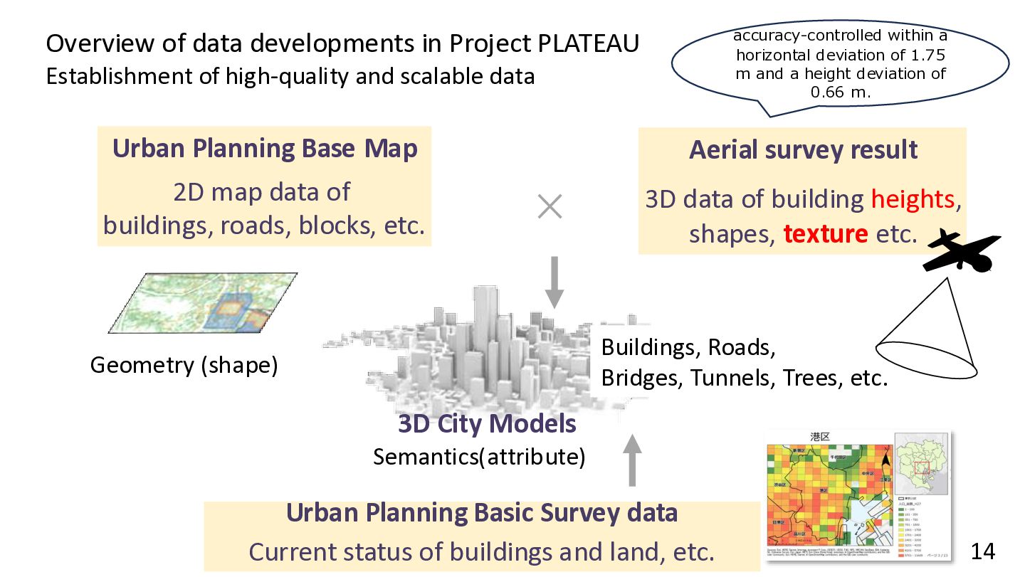
and scalable data Urban Planning Base Map 2D map data of buildings, roads, blocks, etc. Aerial survey result 3D data of building heights, shapes, texture etc. Urban Planning Basic Survey data Current status of buildings and land, etc. 3D City Models Geometry (shape) Semantics(attribute) 14 Buildings, Roads, Bridges, Tunnels, Trees, etc. accuracy-controlled within a horizontal deviation of 1.75 m and a height deviation of 0.66 m.
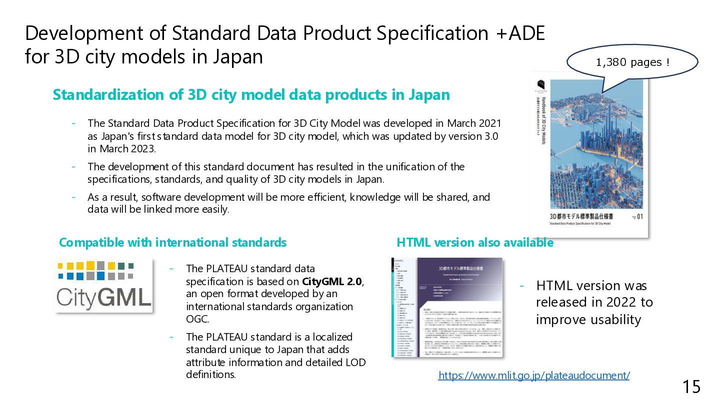
models in Japan - The Standard Data Product Specification for 3D City Model was developed in March 2021 as Japan's first standard data model for 3D city model, which was updated by version 3.0 in March 2023. - The development of this standard document has resulted in the unification of the specifications, standards, and quality of 3D city models in Japan. - As a result, software development will be more efficient, knowledge will be shared, and data will be linked more easily. Standardization of 3D city model data products in Japan - The PLATEAU standard data specification is based on CityGML 2.0, an open format developed by an international standards organization OGC. - The PLATEAU standard is a localized standard unique to Japan that adds attribute information and detailed LOD definitions. Compatible with international standards - HTML version was released in 2022 to improve usability HTML version also available https://www.mlit.go.jp/plateaudocument/ 15 1,380 pages !
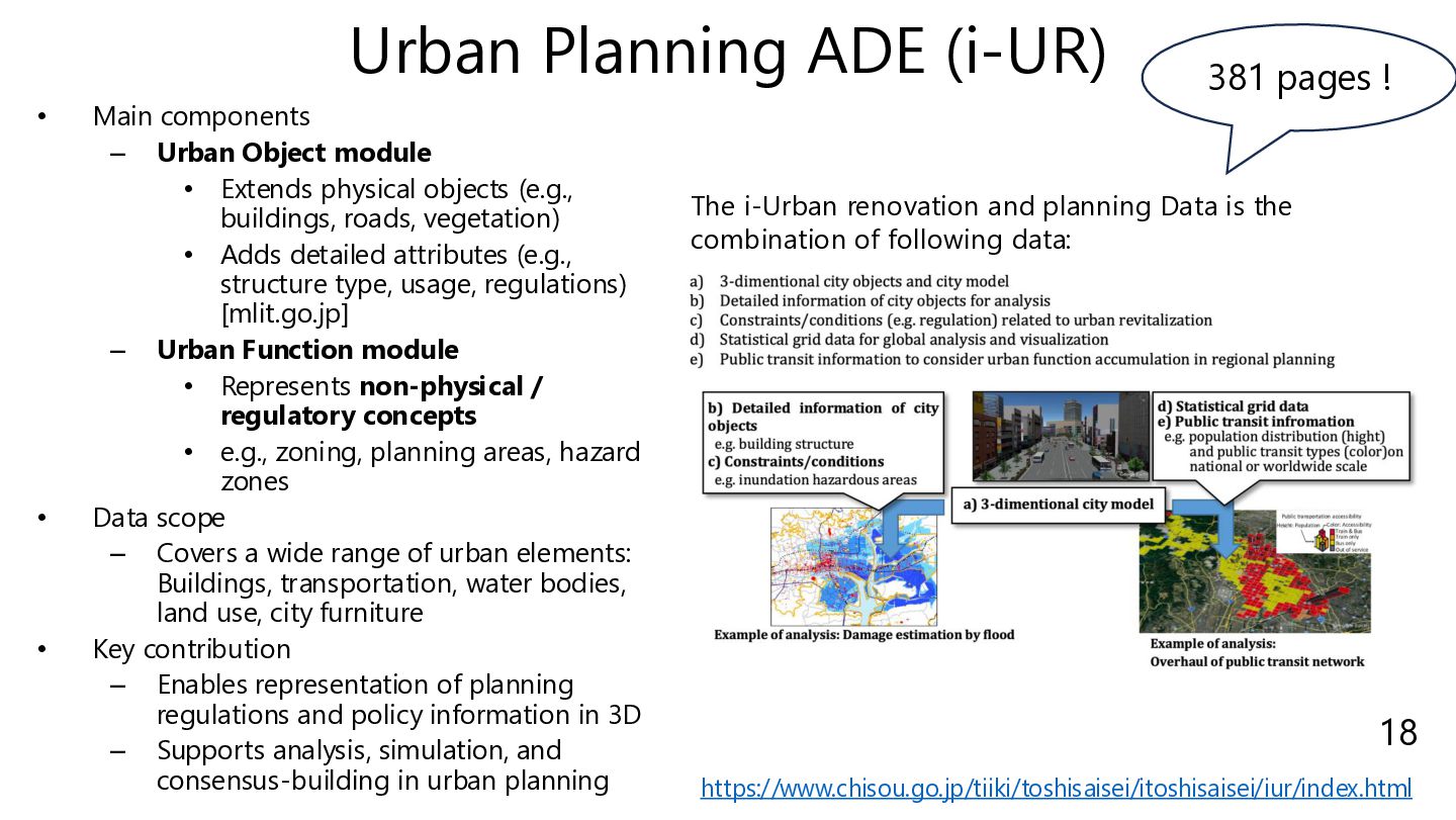
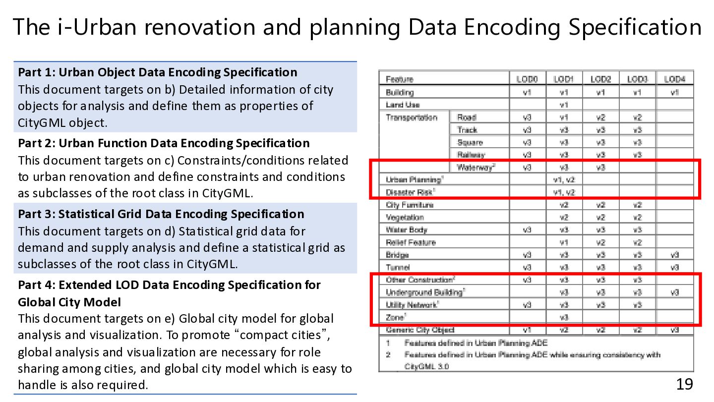
module • Extends physical objects (e.g., buildings, roads, vegetation) • Adds detailed attributes (e.g., structure type, usage, regulations) [mlit.go.jp] – Urban Function module • Represents non-physical / regulatory concepts • e.g., zoning, planning areas, hazard zones • Data scope – Covers a wide range of urban elements: Buildings, transportation, water bodies, land use, city furniture • Key contribution – Enables representation of planning regulations and policy information in 3D – Supports analysis, simulation, and consensus-building in urban planning https://www.chisou.go.jp/tiiki/toshisaisei/itoshisaisei/iur/index.html 18 381 pages ! The i-Urban renovation and planning Data is the combination of following data:
Urban Object Data Encoding Specification This document targets on b) Detailed information of city objects for analysis and define them as properties of CityGML object. Part 2: Urban Function Data Encoding Specification This document targets on c) Constraints/conditions related to urban renovation and define constraints and conditions as subclasses of the root class in CityGML. Part 3: Statistical Grid Data Encoding Specification This document targets on d) Statistical grid data for demand and supply analysis and define a statistical grid as subclasses of the root class in CityGML. Part 4: Extended LOD Data Encoding Specification for Global City Model This document targets on e) Global city model for global analysis and visualization. To promote “compact cities”, global analysis and visualization are necessary for role sharing among cities, and global city model which is easy to handle is also required. 19
1. Global Expansion and Applications • Open 3D geospatial data supports smart cities, urban planning, disaster management, and civic engagement worldwide. 2. National Initiatives and Challenges: for de-centralization SDI • Japan’s PLATEAU and the Netherlands’ 3DBAG show government investment in open 3D data with sustainability challenges. 3. Socio-Technical System • Open 3D data functions as a socio-technical system involving governments, academia, private sectors, and citizens. 4. Context-Sensitive Sustainability • Sustainability requires understanding how data infrastructures are maintained, taught, and used beyond technical aspects. 21
open 3D geospatial data ecosystems achieve long-term sustainability as an SDI?” ✓ RQ1— Technical Sustainability: Web-native 3D geospatial data for a sustainable data commons ✓ RQ2— Socio-institutional Sustainability: Use-cases, governance & education in open 3D-SDI ecosystems (JP NL, with & EU references) 22
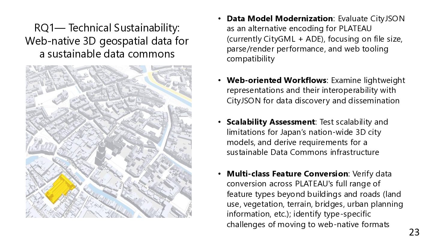
data commons • Data Model Modernization: Evaluate CityJSON as an alternative encoding for PLATEAU (currently CityGML + ADE), focusing on file size, parse/render performance, and web tooling compatibility • Web-oriented Workflows: Examine lightweight representations and their interoperability with CityJSON for data discovery and dissemination • Scalability Assessment: Test scalability and limitations for Japan’s nation-wide 3D city models, and derive requirements for a sustainable Data Commons infrastructure • Multi-class Feature Conversion: Verify data conversion across PLATEAU's full range of feature types beyond buildings and roads (land use, vegetation, terrain, bridges, urban planning information, etc.); identify type-specific challenges of moving to web-native formats 23
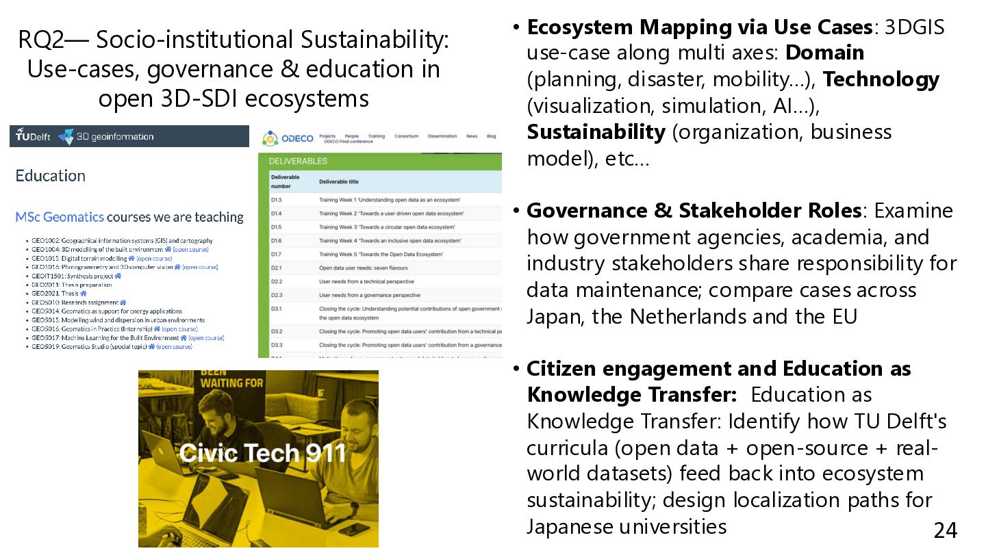
ecosystems • Ecosystem Mapping via Use Cases: 3DGIS use-case along multi axes: Domain (planning, disaster, mobility…), Technology (visualization, simulation, AI…), Sustainability (organization, business model), etc… • Governance & Stakeholder Roles: Examine how government agencies, academia, and industry stakeholders share responsibility for data maintenance; compare cases across Japan, the Netherlands and the EU • Citizen engagement and Education as Knowledge Transfer: Education as Knowledge Transfer: Identify how TU Delft's curricula (open data + open-source + real- world datasets) feed back into ecosystem sustainability; design localization paths for Japanese universities 24
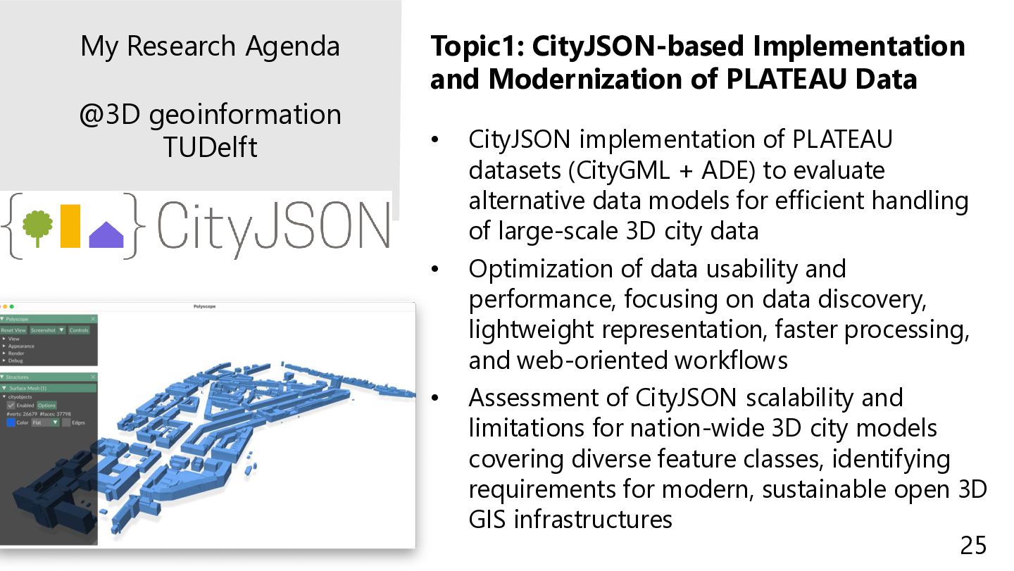
implementation of PLATEAU datasets (CityGML + ADE) to evaluate alternative data models for efficient handling of large-scale 3D city data • Optimization of data usability and performance, focusing on data discovery, lightweight representation, faster processing, and web-oriented workflows • Assessment of CityJSON scalability and limitations for nation-wide 3D city models covering diverse feature classes, identifying requirements for modern, sustainable open 3D GIS infrastructures My Research Agenda @3D geoinformation TUDelft 25
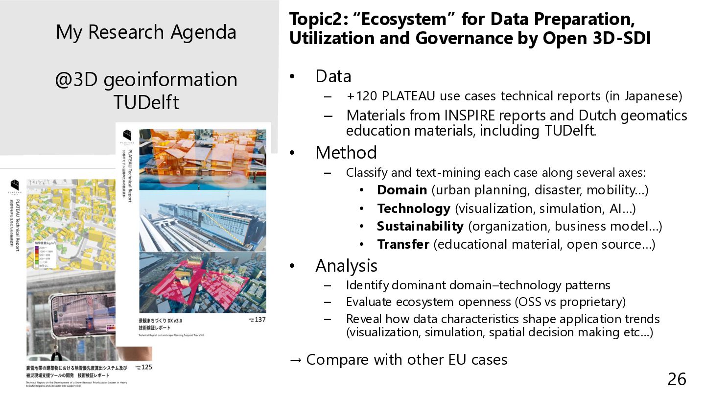
3D-SDI • Data – +120 PLATEAU use cases technical reports (in Japanese) – Materials from INSPIRE reports and Dutch geomatics education materials, including TUDelft. • Method – Classify and text-mining each case along several axes: • Domain (urban planning, disaster, mobility…) • Technology (visualization, simulation, AI…) • Sustainability (organization, business model…) • Transfer (educational material, open source…) • Analysis – Identify dominant domain–technology patterns – Evaluate ecosystem openness (OSS vs proprietary) – Reveal how data characteristics shape application trends (visualization, simulation, spatial decision making etc…) → Compare with other EU cases My Research Agenda @3D geoinformation TUDelft 26
![[email protected] | @tosseto | https://tossetolab.github.io/ Research Introduction: Overview activities during](https://files.speakerdeck.com/presentations/21830ec3ad944db5812f88bac602c908/slide_0.jpg)
![[email protected] | @tosseto | https://tossetolab.github.io/ Resent VGI Research & 3D](https://files.speakerdeck.com/presentations/21830ec3ad944db5812f88bac602c908/slide_3.jpg)
![[email protected] | @tosseto | https://tossetolab.github.io/ OSMCha: Editing Trends Validation International](https://files.speakerdeck.com/presentations/21830ec3ad944db5812f88bac602c908/slide_4.jpg)
![[email protected] | @tosseto | https://tossetolab.github.io/ A large contribution from New](https://files.speakerdeck.com/presentations/21830ec3ad944db5812f88bac602c908/slide_5.jpg)
![[email protected] | @tosseto | https://tossetolab.github.io/ • Herfindahl-Hirschman Index (HHI) •](https://files.speakerdeck.com/presentations/21830ec3ad944db5812f88bac602c908/slide_6.jpg)
![[email protected] | @tosseto | https://tossetolab.github.io/ Regional Distribution & Editor Concentration](https://files.speakerdeck.com/presentations/21830ec3ad944db5812f88bac602c908/slide_7.jpg)
![[email protected] | @tosseto | https://tossetolab.github.io/ Role of 3D City Model](https://files.speakerdeck.com/presentations/21830ec3ad944db5812f88bac602c908/slide_8.jpg)
![[email protected] | @tosseto | https://tossetolab.github.io/ PLATEAU-OSM Coverage Comparison PLATEAU 3D](https://files.speakerdeck.com/presentations/21830ec3ad944db5812f88bac602c908/slide_9.jpg)
![[email protected] | @tosseto | https://tossetolab.github.io/ Modules of the PLATEAU standard](https://files.speakerdeck.com/presentations/21830ec3ad944db5812f88bac602c908/slide_15.jpg)
![[email protected] | @tosseto | https://tossetolab.github.io/ 地下埋設物モデル-UtilityNetwork 地下街モデル-UndergroundBuilding LOD1 LOD3 LOD2](https://files.speakerdeck.com/presentations/21830ec3ad944db5812f88bac602c908/slide_16.jpg)
![[email protected] | @tosseto | https://tossetolab.github.io/ Background: Open 3D-SDI and Sustainability](https://files.speakerdeck.com/presentations/21830ec3ad944db5812f88bac602c908/slide_20.jpg)
![[email protected] | @tosseto | https://tossetolab.github.io/ Research Question • “How can](https://files.speakerdeck.com/presentations/21830ec3ad944db5812f88bac602c908/slide_21.jpg)
![Dank u wel / Thank You Toshikazu SETO, Ph.D. [email protected]](https://files.speakerdeck.com/presentations/21830ec3ad944db5812f88bac602c908/slide_27.jpg)