Upgrade to Pro — share decks privately, control downloads, hide ads and more …

Aquapuncture: Sustainable Future of Inland Waterways

WCC Scotland
September 22, 2016

Aquapuncture: Sustainable Future of Inland Waterways

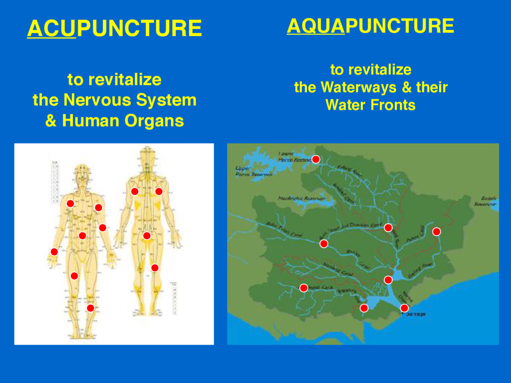
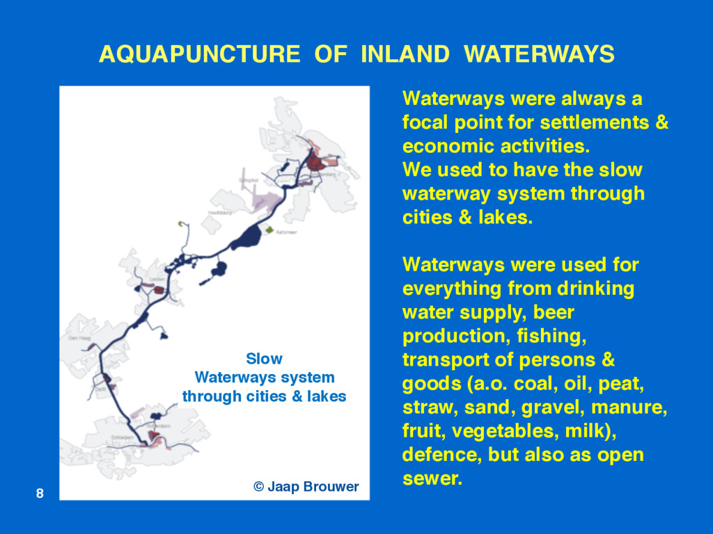
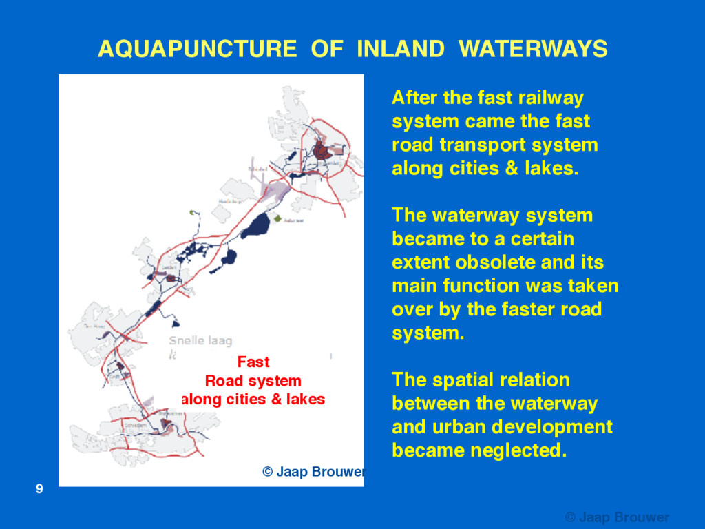
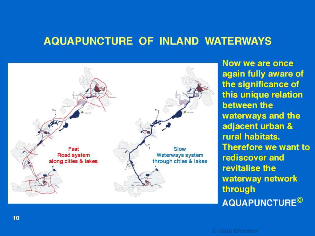
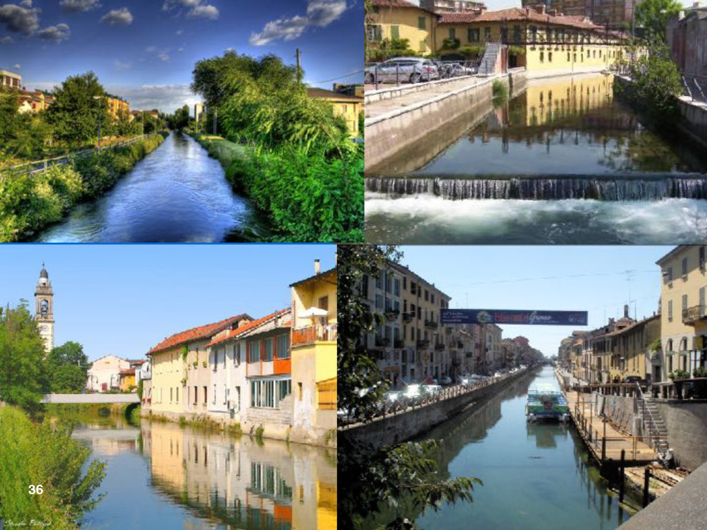
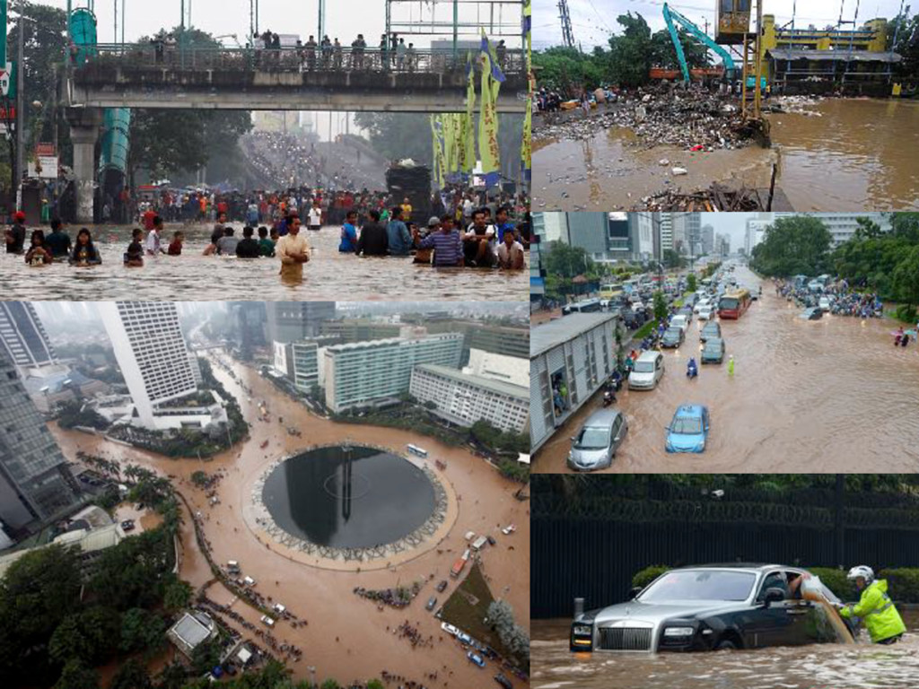
Waterways were always a focal point for settlements & economic activities. Worldwide we used to have the slow waterway system through cities and lakes. They were used for a great number of functions. All the inland waterways formed a slow waterway system, going through the city centres and connecting them in a direct way, linking urban and rural areas. This changed with the rise of the much faster railway and road system through and around the cities. The waterway transport system became to a certain extent obsolete and its main function was taken over. The spatial relation between the waterway and the urban development became neglected.
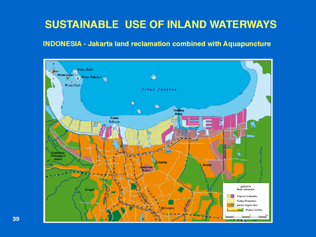
WCC Scotland

September 22, 2016
Tweet

More Decks by WCC Scotland

Other Decks in Research

Transcript

  1. SUSTAINABLE FUTURE OF INLAND WATERWAYS
    Dr. Ronald E. Waterman MSc
    co-author:
    Jaap A. Brouwer MUrb

    WCC – 2016
    Inverness

    AQUAPUNCTURE©
    1

    View Slide

  2. 2
    Dr. Ronald E. Waterman MSc


    Senior Consultant

    Building with Nature®
    Aquapuncture®


    www.ronaldwaterman.nl
    www.ronaldwaterman.com
    www.ronaldwaterman.es
    Ing. Jaap A. Brouwer MUrb

    Waterways expert
    Urban designer
    Lecturer Academy of Architure of
    Amsterdam
    www.aquapunctuur.nl

    View Slide

  3. Stimulating the Blue Green Economy
    for
    Regional, Socio-Economic & 

    Spatial Development,
    while safeguarding
    Safety, Navigability as well as
    Environmental Values & Nature
    SUSTAINABLE FUTURE OF INLAND WATERWAYS
    3

    View Slide

  4. AQUAPUNCTURE©
    4
    Introduction of AQUAPUNCTURE©
    Optimal use, adaptation, experience and
    management of inland waterways and
    their waterfronts
    for safety, navigability, economy, employment,
    environment and nature-landscape.

    View Slide

  5. AQUAPUNCTURE


    to revitalize 

    the Waterways & their

    Water Fronts
    ACUPUNCTURE
    to revitalize
    the Nervous System
    & Human Organs

    View Slide

  6. SUSTAINABLE COASTAL ZONE DEVELOPMENT

    About 80 % of the major
    cities can be found in coastal
    and deltaic areas
    A large part of the remaining
    20% can be found upstream
    along rivers, lakes & canals

    View Slide

  7. European
    Inland
    Waterways
    7

    View Slide

  8. AQUAPUNCTURE OF INLAND WATERWAYS
    Fast
    Road system
    along cities & lakes
    8
    Waterways were always a
    focal point for settlements &
    economic activities.
    We used to have the slow
    waterway system through
    cities & lakes.
    Waterways were used for
    everything from drinking
    water supply, beer
    production, fishing,
    transport of persons &
    goods (a.o. coal, oil, peat,
    straw, sand, gravel, manure,
    fruit, vegetables, milk),
    defence, but also as open
    sewer.
    Slow
    Waterways system
    through cities & lakes
    © Jaap Brouwer

    View Slide

  9. AQUAPUNCTURE OF INLAND WATERWAYS
    Fast
    Road system
    along cities & lakes
    Slow
    Waterways system
    through cities & lakes
    © Jaap Brouwer
    9
    After the fast railway
    system came the fast
    road transport system
    along cities & lakes.
    The waterway system
    became to a certain
    extent obsolete and its
    main function was taken
    over by the faster road
    system.
    The spatial relation
    between the waterway
    and urban development
    became neglected.
    © Jaap Brouwer

    View Slide

  10. AQUAPUNCTURE OF INLAND WATERWAYS
    Fast
    Road system
    along cities & lakes
    Slow
    Waterways system
    through cities & lakes
    © Jaap Brouwer
    10
    Now we are once
    again fully aware of
    the significance of
    this unique relation
    between the
    waterways and the
    adjacent urban &
    rural habitats.
    Therefore we want to
    rediscover and
    revitalise the
    waterway network
    through
    AQUAPUNCTURE©

    View Slide

  11. 11
    © J.A. Brouwer / R.E. Waterman 2012
    User Groups
    Urban & Rural

    Characteristics
    Organisation
    Interventions
    Physical Adaptations

    View Slide

  12. 12

    View Slide

  13. 13

    View Slide

  14. Urban & Rural Characteristics along the Waterways
    2
    1 3 4 5 6 7
    Connection Inland Waterway with Seaport Marina &
    Nature Reserve Areas via Building with Nature©
    1 Soft Coastal Defense
    2 City
    3 Village
    4 Culture & History
    5 Farms, Agriculture, Horticulture, Nature
    6 Modern City & Port
    7 Strong Coastal Defence
    Connection Inland Waterway with Mainport Development &
    Nature Reserve Area via Building with Nature©

    View Slide

  15. User Groups in and along the Waterways
    Commercial Shipping
    Tourism & Recreation
    Special Nautical Events
    Water Related Sports
    Waterfront Users & Developers
    Aquatic / Terrestrial Flora & Fauna

    View Slide

  16. Physical Adaptations - Interventions
    Physical Adaptations Enhancing Spatial Qualities
    Measures for improving

    Safety & Environment
    Mitigating measures with
    regard to Climate Change
    Realisation of Facilities
    Safety including
    Nautical Safety
    Water use for
    Agriculture
    Aquaculture
    Drinking Water
    Cooling & Process Water
    Energy
    Transport
    Water Level Control

    View Slide

  17. Organisation for Waterway & Waterfront Development
    Stakeholder Participation

    Public & Private Partnership
    Societal Costs & Benefits
    Cooperation with 5 levels of Government
    Trias Politica: Legislative / Judicial / Executive Power
    Knowledge & Education
    Information, Awareness, Promotion
    Communication Tools (e.g. Internet & Apps)

    View Slide

  18. Physical Adaptations - Interventions
    Height bridges
    above water surface
    Depth waterway
    through
    environment-
    friendly dredging
    Enlarging sluice /
    shiplock capacity
    Water Level Control

    View Slide

  19. Physical Adaptations - Interventions
    Urban development
    with connecting
    waterways
    Boat conveyor

    View Slide

  20. Realisation of Facilities
    Yachting harbour
    Moorings
    Berths with facilities
    Jetties, Quay walls,
    Loading/Unloading
    Platforms
    Container Terminals

    View Slide

  21. Safety including Nautical Safety
    Safety against
    Flooding
    Nautical Safety

    View Slide

  22. Enhancing Spatial Qualities
    Enhancing
    blue-green
    spatial qualities of
    rural & urban areas

    View Slide

  23. Enhancing Spatial Qualities
    City meets
    blue-green
    landscape

    View Slide

  24. Mitigating measures with regard to Climate Change
    Flood Prevention
    Room for
    the River
    Calamity Storage
    Retention Basins

    View Slide

  25. Measures for Improving the Environment
    Waste Water
    Emission
    Prevention
    Waste Water
    Purification
    Water Framework
    Directive

    View Slide

  26. Societal Costs & Benefits Analysis
    For the physical adaptations / interventions in and along the waterways initial
    investments are necessary. These are followed in a later stage by revenues of
    various types and from various sources.
    • WATER QUANTITY REVENUES

    flood prevention, surface- & ground water regulation, drainage, irrigation for agriculture,
    drinking water supply, cooling water, process water, water flow energy 

    • WATER QUALITY REVENUES

    water quality: beneficial to environment, nature & health

    • NAVIGABILITY REVENUES

    transport of persons and goods, water related sports, tourism & recreation

    • WATERFRONT ATTRACTION REVENUES 

    increased liveability, economic activities and increased value of property

    • SPATIAL QUALITY REVENUES 

    improved urban & rural environment, preservation & restoration of cultural heritage,
    attractive residential areas, leisure parks, sustainable industrial parks; overall
    sustainability also with regard to climate & climate change

    View Slide

  27. Aquapuncture - Shared Value:
    Societal Costs & Benefits
    Measurement Model

    View Slide

  28. SWEDEN (Värmland)
    Göta Ǻlv –
    Trollhättan Kanal –
    Vänern – Klarälven
    Göta Kanal –
    Vättern Kanal –
    Göta Kanal 


    Waterway between 


    Kattegat & Baltic Sea
    28

    View Slide

  29. SUSTAINABLE USE OF INLAND WATERWAYS
    Vänern
    Göta Kanal
    29

    View Slide

  30. Falkirk Wheel
    SUSTAINABLE USE OF INLAND WATERWAYS
    30

    View Slide

  31. SUSTAINABLE FUTURE OF INLAND WATERWAYS
    Special berths
    with facilities
    31

    View Slide

  32. SUSTAINABLE FUTURE OF INLAND WATERWAYS
    New inland
    container terminal
    for brewery
    32
    New sluice
    for shipbuilding

    View Slide

  33. 33
    Sustainable
    whispering route
    Duurzame
    fluisterroute
    in de historische
    binnenstad
    Met speciale smalle, elektrisch
    aangedreven
    vaartuigen met een beperkt aantal
    zorgvuldig gekozen
    aanmeerplaatsen
    Good plans have their roots in the past
    and
    are pointing towards the future
    Goede plannen wortelen in het
    verleden en
    wijzen naar de toekomst

    View Slide

  34. 34
    Canal Cruise Sustainable

    Rondvaarboten whispering route
    &

    View Slide

  35. ITALY
    Navigli
    Lombardi

    s.c.a.r.l.
    Milano
    Province
    Lombardi

    Region:
    canal system

    250 km

    in an area of

    1,800 km²
    Lombardi Canals /
    da Vinci Canals
    between
    Milano – Lago di Como – Lago
    Maggiore
    Ticino River – Po River – Adda
    River
    35

    View Slide

  36. ITALY
    (Navigli
    Lombardi)
    Milano
    Province
    Lombardi Canals / da Vinci Canals between
    Milano – Lago di Como – Lago Maggiore
    Ticino River – Po River – Adda River
    36

    View Slide

  37. SINGAPORE - Transformation of rivers & canals into blue-green artiries
    SUSTAINABLE USE OF INLAND WATERWAYS
    37

    View Slide

  38. SINGAPORE – Kallang River before and after transformation
    38

    View Slide

  39. SUSTAINABLE USE OF INLAND WATERWAYS
    39
    INDONESIA - Jakarta land reclamation combined with Aquapuncture

    View Slide

  40. Djakarta Rivieren
    LOCATION OF 11 RIVERS & 2 DRAINAGE CANALS IN PANTURA ZONE OF JAKARTA
    Necessity of upgrading waterway system through Aquapuncture

    View Slide

  41. View Slide

  42. View Slide

  43. Length 120 km, from Catagena to
    Rio Magdalena & Calamar
    Recuperation complete with dikes,
    new locks & 

    marsh improvements
    AGUAPUNTURA©
    for the optimal use & adaptation of
    the waterway
    and the waterfronts for economy,
    employment, environment, nature
    & landscape
    COLOMBIA - Recuperación del Canal del Dique
    SUSTAINABLE USE OF INLAND WATERWAYS

    View Slide

  44. 44
    © J.A. Brouwer / R.E. Waterman 2012
    User Groups
    Urban & Rural

    Characteristics
    Organisation
    Interventions
    Physical Adaptations

    View Slide

  45. © J.A. Brouwer / R.E. Waterman 2012
    Urban & Rural

    Characteristics
    Organisation
    Thank you

    View Slide