Upgrade to Pro — share decks privately, control downloads, hide ads and more …

A Cost Effective Method of Mobile Data Collection by Ashok Wadwani

A Cost Effective Method of Mobile Data Collection by Ashok Wadwani

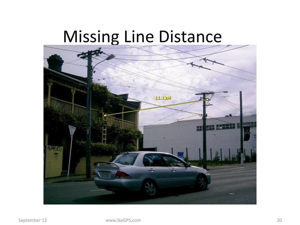
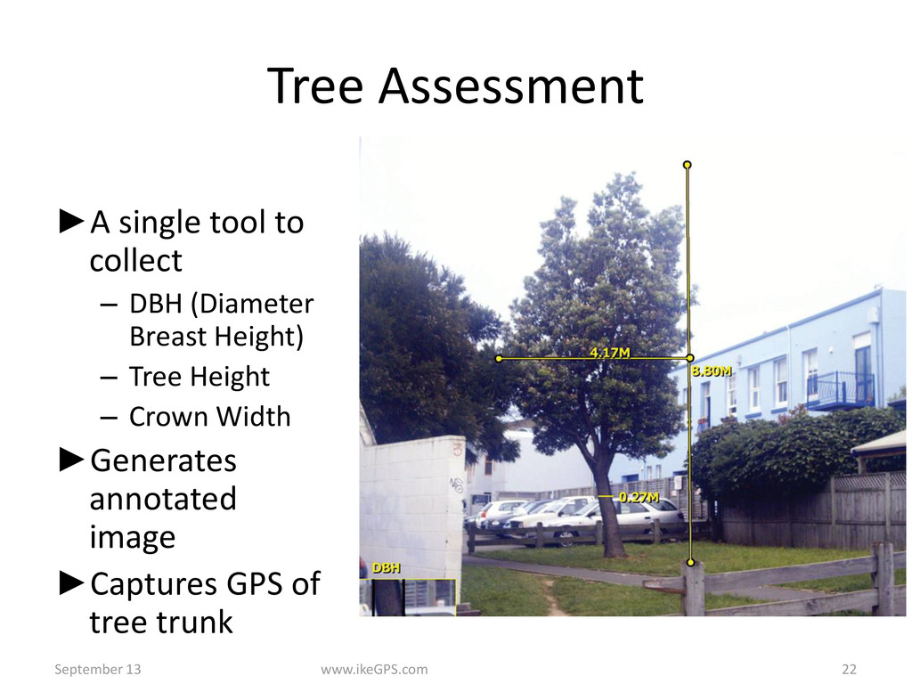
The presentation will cover GIS/GPS field data collection on the Android and the iPad Platforms. Not only you can collect feature/attribute data but also display the data in the field on a Google map. Once the field data is collected, it can be transferred instantly if WiFi connection is available or saved and transferred later. The program can use built-in GPS or external GPS for higher accuracy. External sensors such as Laser Range Finder can also be used with Bluetooth option. The program can read various types of bar codes including the new DIMP (Distribution Integrity Management program) codes. Once the data is downloaded various custom reports and shapefiles can be generated.

More Decks by Arkansas GIS Users Forum Conference

Other Decks in Technology

Transcript

  1. A New Cool Toy for GIS Mapping AR GIS FORUM

    ROGERS,AR Ashok Wadwani AFDS, Houston, TX
  2. GPS/GIS Data Collection • Typically Users currently utilize • GPS

    receiver • Camera • Laser Range Finder (distance and compass)
  3. Better alternative is ►IKE a integrated GPS, COMPASS, LASER and

    CAMERA unit with Windows Mobile OS ►Allowing software like ARCPAD to run
  4. IKE IS A All-in-one mobile GIS solution Integrated camera, laser

    range finder, 3D compass, rugged PDA, GPS Fast and Accurate Locate, Measure, Document Point, Shoot, Download ww.ikeGcom 4
  5. ikeGPS www.ikeGS.com 5 5 Sub-meter GPS 3D compass • Ferrous

    metals distort magnetic field Accurate Rangefinder • 300m or 1000m range Best-in-class camera • 5.2 megapixel • 10x digital zoom SD Card Access Power Button
  6. What is ikeCapture? ►Uses laser range, compass heading, inclinometer angle

    ►and ike’s GPS coordinates to calculate the position of ►the remote target ►Captures a jpeg image of the target and embeds all data ► in the image’s EXIF header ►Stores data in – CSV file – KML file for use Google Earth ►Can be integrated into other applications 6
  7. ikeCapture ►Target Image ►Distance to target ►Bearing ►Skyplot ►PDOP ►GPS

    Fix Type ►High Accuracy GPS Option September 13 www.ikeGPS.com 7
  8. Target Position Applet ►Tap Capture or press Enter key ►Use

    virtual keyboard to enter label and comments September 13 www.ikeGPS.com 9
  9. Span Height Measurement Steps Check Distance to verify wire is

    targeted not background September 13 www.ikeGPS.com 10
  10. Applications Utility applications-Line sags, vegetation mapping, pole audits Emergency Response-Damage

    evaluations Infrastructure audits-Traffic signs, trees, bill boards, appraisals Geological mapping in remote areas
  11. ►A single tool to collect – DBH (Diameter Breast Height)

    – Tree Height – Crown Width ►Generates annotated image ►Captures GPS of tree trunk 7 Step workflow 1.Capture Base elevation 2.Tree trunk 3.Top of tree 4.Left side of crown 5.Right side of crown 6.Mark Trunk edges 7.Centered image September 13 www.ikeGPS.com 22 Tree Assessment
  12. POLE AUDITS • Utilities and their service providers conduct audit

    of poles routinely for accurate measurement of attachments, heights, distances and vegetation management. • Typical field survey involves hundreds and thousands of poles for power companies, cable companies and regulators. • Due to fires traced to pole attachments , CA requires certification of each pole.
  13. POLE AUDIT CONT’D • Most of the audits are manual

    • Expensive and time consuming • Risky • Hand written notes transcription errors, data not matching meant crew needs to go back
  14. Better Solution- xpoGIS • IkeGPS • Allows accurate measurements of

    attachments, heights, distances from a single image that can be captured from a safe distance • ikeGPS is a all in one handheld GPS data capture device combining GPS. Laser range finder, 3d compass, geo-tagged photo images, 3d photogrammetry and integration with GIS
  15. BENEFITS • Eliminates manual measurements process taking long time and

    at least 2 crew members. No need to use rods. • The more attachments more complex the job. • Field data acquisition now takes one third the time. • Crew used to do about 35 poles a day now we can do 100-150 poles a day. • For low point in cable span, you have to stand under the span in the traffic zone, Very risky • Saves measurement time by almost 80% with one crew member averages 1 minute per target by one person. • All data digitally recorded-no manual notes • A permanent record with location data is created
  16. Benefits Cont’d • ikeAnnotate exports CSV and pdf files to

    help you visualize locations and data for every featutre using your web browser and ESRI OR Google Earth applications.
  17. Other Applications • Disaster management • Power lines, fallen trees,

    debris, damage assessment, • Asset data-Traffic signs, Trees, Properties, Fire Hydrants, Manholes, Advertising bill boards • Environmental applications