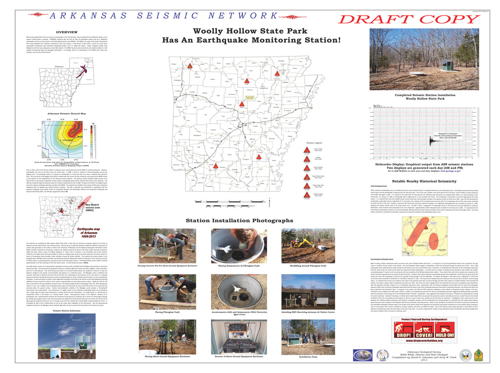
§ ¨ ¦ 40 § ¨ ¦ 40 § ¨ ¦ 30 § ¨ ¦ 30 § ¨ ¦ 540 § ¨ ¦ 40 § ¨ ¦ 440 § ¨ ¦ 430 § ¨ ¦ 30 § ¨ ¦ 530 § ¨ ¦ 540 § ¨ ¦ 40 § ¨ ¦ 30 £ ¤ 64 £ ¤ 62 £ ¤ 412 £ ¤ 65 £ ¤ 49 £ ¤ 67 £ ¤ 71 £ ¤ 64 £ ¤ 67 £ ¤ 67 £ ¤ 49 £ ¤ 49B £ ¤ 79B £ ¤ 79 £ ¤ 63 £ ¤ 165 £ ¤ 70 £ ¤ 270 £ ¤ 270 £ ¤ 71 £ ¤ 70 £ ¤ 63 £ ¤ 79 £ ¤ 63 £ ¤ 79 £ ¤ 278 £ ¤ 167 £ ¤ 82S £ ¤ 165 £ ¤ 167 Rogers Gilmore Beebe Clinton Ozark Cherokee Village Harrison Batesville Grannis Walnut Ridge Warren Glenwood Mulberry Prescott Ashdown Stuttgart Piggott Brinkley Pocahontas McGehee De Queen Rosston Hazen Waldron Marked Tree Nashville Eureka Springs Bald Knob Dumas Sheridan Stamps Marianna Hamburg Huntsville Hampton Marshall Enola Lake Village Mount Ida Yell Polk Lee White Scott Pope Union Clark Drew Pike Clay Ashley Desha Benton Logan Saline Izard Miller Lonoke Newton Arkansas Cross Pulaski Grant Stone Perry Chicot Dallas Prairie Jefferson Sharp Searcy Phillips Madison Boone Sevier Poinsett Fulton Carroll Marion Garland Baxter Bradley Nevada Mississippi Monroe Greene Ouachita Washington Columbia Johnson Lincoln Jackson Howard Calhoun Faulkner Franklin Conway Craighead Randolph Van Buren Crawford Hempstead Woodruff Cleburne Montgomery Lawrence Cleveland Lafayette Crittenden St. Francis Hot Spring Independence Sebastian Little River Mena £ ¤ 63 £ ¤ 71 £ ¤ 165 £ ¤ 64 £ ¤ 371 £ ¤ 62 £ ¤ 63 £ ¤ 70 £ ¤ 61 £ ¤ 278 £ ¤ 167 £ ¤ 82 £ ¤ 79 £ ¤ 412 £ ¤ 65 £ ¤ 67 £ ¤ 270 £ ¤ 425 £ ¤ 79B £ ¤ 64B £ ¤ 271 £ ¤ 165 £ ¤ 82 £ ¤ 70 £ ¤ 49 £ ¤ 65 £ ¤ 412 £ ¤ 63 £ ¤ 71 £ ¤ 65 £ ¤ 425 £ ¤ 79 £ ¤ 65 £ ¤ 70 £ ¤ 63 £ ¤ 65 £ ¤ 371 £ ¤ 65 £ ¤ 278 £ ¤ 278 £ ¤ 278 £ ¤ 62 £ ¤ 82 £ ¤ 63 £ ¤ 62 £ ¤ 79 £ ¤ 49 £ ¤ 49 £ ¤ 79 £ ¤ 167 £ ¤ 270 £ ¤ 70 £ ¤ 71 £ ¤ 82 £ ¤ 63 £ ¤ 270 £ ¤ 371 £ ¤ 70 £ ¤ 64 £ ¤ 67 £ ¤ 71 £ ¤ 64 £ ¤ 79 £ ¤ 70 £ ¤ 71B £ ¤ 71 £ ¤ 65 £ ¤ 49 £ ¤ 64 £ ¤ 82 £ ¤ 62 £ ¤ 71B £ ¤ 79 £ ¤ 67 £ ¤ 70 £ ¤ 67 £ ¤ 82 £ ¤ 67 £ ¤ 62 £ ¤ 64 £ ¤ 62 £ ¤ 62 £ ¤ 371 £ ¤ 425 £ ¤ 412 £ ¤ 278 £ ¤ 167 £ ¤ 67 WHAR FCAR LCAR HHAR WLAR CCAR 20 0 20 40 60 80 100 10 Miles 20 0 20 40 60 80 100 10 Kilometers (N Woolly Hollow State Park Station Legend # * # * # * # * # * # * Cane Creek State Park (CCAR) Hobbs State Park (HHAR) Woolly Hollow State Park (WHAR) Ozark Folk Center State Park (FCAR) White Oak Lake State Park (WLAR) Lake Charles State Park (LCAR) Woolly Hollow State Park Has An Earthquake Monitoring Station! Arkansas Geological Survey Bekki White, Director and State Geologist Compilation by David H. Johnston and Jerry W. Clark 2013 A R K A N S A S S E I S M I C N E T W O R K Completed Seismic Station Installation Woolly Hollow State Park Station Installation Photographs Helicorder Display: Graphical output from ASN seismic stations Two displays are generated each day (AM and PM) Go to AGS Website to view near real-time displays: www.geology.ar.gov Arkansas Seismic Hazard Map Seismic Station Schematic Pouring Concrete Pad For Above-Ground Equipment Enclosure Placing Seismometer In Fiberglass Vault Placing Fiberglass Vault Placing Above-Ground Equipment Enclosure Accelerometer (left) and Seismometer With Protective Igloo Cover Interior of Above-Ground Equipment Enclosure Backfilling Around Fiberglass Vault Installing WiFi Receiving Antenna At Visitor Center Installation Team Fiberglass Vault 900 Mhz Antenna Solar Panels Seismic Sensors Above-Ground Equipment Enclosure Notable Nearby Historical Seismicity OVERVIEW Enola Earthquake Swarm When numerous earthquakes occur in a localized area over a short period of time, it is typically referred to as an earthquake swarm. Earthquake swarms with measurable events have occurred periodically in Arkansas over the last forty years. One of the most notable is the Enola Swarm that occurred in central Faulkner County during the early 1980’s and again in 2001. It is named for the small town of Enola because the individual event epicenters are mapped either within or in close proximity to this community. On January 12, 1982, an earthquake with a magnitude of 1.2 was recorded near Enola. This earthquake is considered to mark the beginning of the Enola Swarm. It is reported that more than 40,000 seismic events have been instrumentally recorded in the general vicinity of Enola since 1982. Since the felt threshold for earthquakes is generally around a magnitude of 2.5 or greater and a majority of the recorded events were less than 2.5 in magnitude, most of the events went unnoticed by those that live in the area. However, numerous felt events have also been reported including a 4.5 magnitude earthquake that was recorded on January 21, 1982, making it the largest seismic event in the Enola swarm area. On May 4, 2001, a magnitude 4.4 earthquake struck in the Enola area and was followed by numerous aftershocks, some of which measured greater than 2.0 in magnitude. Approximately 2,500 earthquakes were recorded in the Enola area in 2001. It’s reported that the Enola Swarm earthquakes resulted in no structural damage, although there have been reports of broken china near the epicenters of some of the larger events. The Enola Swarm seismicity is considered to have been naturally occurring and unrelated to the New Madrid seismic zone. When many people think of the occurrence of earthquakes in the United States, they invariably think of California, Alaska, or the western United States in general. HOWEVER, Arkansas also has had its share of earthquake activity and has a significant earthquake risk from an area known as the New Madrid seismic zone (NMSZ). The NMSZ is an active fault system that extends from around Marked Tree, Arkansas northward to near Cairo, Illinois. In the winter of 1811-1812, a series of at least three catastrophic earthquakes with estimated magnitudes greater than 7.5 rattled the region. Cabins collapsed, people were frightened and there was widespread surface deformation. The NMSZ has been active since then and scientists believe it is still capable of producing large and damaging earthquakes. On average, there is an earthquake on the NMSZ every other day; however, most are too small to be felt. Prior to 2010, most of the seismic stations in Arkansas were concentrated around the NMSZ in northeast Arkansas. However, earthquakes can occur at any time across the entire State. In 2008, a series or “swarm” of small earthquakes struck near Magnet Cove. An earthquake swarm is a sequence of earthquakes in a local area that occur over a relatively short period of time. The occurrence of the Magnet Cove Swarm coupled with the seismic risk that continues to be posed by the NMSZ served as the impetus for the establishment of the Arkansas Seismic Network. The Arkansas Seismic Network (ASN) consists of six state-of-the-art permanent broad-band seismic stations strategically placed within selected State Parks across Arkansas. The ASN was funded through the Arkansas Governor’s General Improvement Fund in 2008. The goal of the ASN is to establish better and more uniform earthquake detection outside of the NMSZ. The network was installed in the spring of 2010 and is seamlessly integrated with the regional and national seismic networks. The ASN is operated and maintained in cooperation with the Arkansas Geological Survey (AGS), Center for Earthquake Research and Information (CERI) at the University of Memphis and Arkansas State Parks (ASP). The ASN was assigned the code of AG. The rationale for installing the ASN stations within State Parks is that they are located on property owned by the State of Arkansas and the Visitor Centers have Internet access. Internet access is important because it allows the efficient conveyance of seismic data generated at the station to CERI at the University of Memphis and the National Earthquake Information Center (NEIC) in Denver, Colorado for processing. However, the stations could not be sited at the Visitor Centers because of vehicular traffic and other human causes of artificial vibrations or “noise” that is common in the immediate area of the Centers. Therefore, the stations were sited and installed in remote or relatively quiet areas of the Parks away from the Visitor Centers to avoid, to the greatest extent possible, undue vibrations caused by human activities. This required the seismic stations to be equipped with a 900 MHz radio transmitter and directional antenna allowing the wireless transmission of the continuous stream of seismic data to a receiving antenna mounted at each of the Park Visitor Centers. The Woolly Hollow seismic station is located approximately 1,175 feet northwest of the Park Visitor Center. Its ASN network acronym is WHAR. Each ASN station consists of an above-ground equipment enclosure with a partially buried fiberglass vault located no more than twenty feet away. The above-ground equipment enclosure is weather tight and contains primarily a digitizer, radio transmitter, and four 12-volt batteries. Two south-facing solar panels are mounted directly above the equipment enclosure to keep the batteries charged so the seismic instrumentation will operate on a continuous basis. The fiberglass vault is cylindrical and measures three feet in diameter by three and one-half feet tall. Depending on the thickness of the soil column, it is typically placed around three feet below the ground surface on approximately six inches of freshly poured cement in a hole excavated by a backhoe. A three-inch layer of cement is then added and smoothed at the base of the interior of the vault followed by pouring additional cement around the exterior of the vault to approximately one foot below ground surface. Ideally the hole for the vault is excavated to the top of bedrock; however, this is not always possible based on the geology of the site. After allowing the cement to cure, soil is added to the remaining exterior space and mounded up and around that portion of the vault that may protrude above the ground surface. Seismic instrumentation installed in the fiberglass vaults includes a “broad-band” seismometer and accelerometer. The seismometer is a digital version of the traditional seismograph which senses vibrations over a large range of seismic wave frequencies or bands, hence the term broad-band. An accelerometer is a special type of seismometer which is also known as a “strong motion” sensor. Strong ground motion is the engineers’ measure of an earthquake’s size. Accelerometers measure the movement of the ground at a particular site in terms of a percentage of gravity (g). Wiring that supplies power to the vault instruments and cables that convey seismic data from the vault to the interior of the above-ground equipment enclosure are run through a two-inch PVC conduit with a burial depth of approximately six inches. A removable lid with a lock is bolted down on top of the vaults after installation of the instruments. Like the above-ground equipment enclosure, the fiberglass vault is weather tight which serves to protect the instruments from moisture intrusion. Guy-Greenbrier Earthquake Swarm More recently, another earthquake swarm occurred in the area of Woolly Hollow State Park. It is referred to as the Guy-Greenbrier Swarm and is named for the two towns in Faulkner County closest to the activity. The Guy-Greenbrier Swarm began in September of 2010 and continued through the latter part of 2011. Over 1,300 earthquakes were reported by the USGS during this time period in the Guy and Greenbrier area. Moreover, it is estimated that thousands of the earthquakes associated with the swarm were too small to be located and reported by USGS seismologists. It is likely that the number of reported events would be lower and/or the location uncertainty greater if it were not for the presence and close proximity of the Woolly Hollow seismic station. Those events that could not be located and a majority of the events that were reported were too small to be felt by humans. However, there were hundreds of earthquakes greater than magnitude 2.0 with many of these events felt locally and some with magnitudes of around 3.0 or greater strong enough to be felt regionally. The largest earthquake in the swarm was a magnitude 4.7 event that struck three miles northeast of Greenbrier at 11:00 PM on February 27, 2011. Felt reports were widespread across Arkansas and it was also felt in portions of surrounding states. It’s reported that at least one residence very close to the epicenter had some structural damage and there were reports of cracked windows, items knocked off shelves, and cracks in plaster walls in Greenbrier and areas just north. Over time, the swarm migrated from the northeast near Guy to the southwest around Greenbrier with the epicenters forming a distinct 12 to 14 kilometer long linear trend. Researchers with the Arkansas Geological Survey (AGS) and the Center for Earthquake Research (CERI) at the University of Memphis determined that the linear trend of the earthquake epicenters illuminates a previously unknown, sub-surface fault which has been named the Guy-Greenbrier Fault. In response to the swarm, the AGS and CERI researchers deployed a local network of temporary seismic stations in the Guy- Greenbrier area to augment the ASN seismic stations. Initially, it was believed by many that the swarm of earthquakes had been triggered by drilling activities associated with the production of natural gas from the Fayetteville Shale Formation. Specifically, it was suggested that hydraulic fracturing or “fracking” was responsible for causing the swarm seismicity. Hydraulic fracturing is a method where water-based fluids are pumped into production wells at very high pressures to create fractures that extend hundreds of feet into surrounding rock formations to allow oil or gas to flow more readily into the well bore for extraction. Investigation of the swarm found no link between the relatively shallow production well drilling or completion practices and the earthquakes but instead pointed to a potential link with nearby deep injection wells that were used to dispose of the flowback fluid from the hydraulic fracturing process. Based on this possibility, the Arkansas Oil and Gas Commission decided that four permitted wastewater injection wells in the vicinity of the swarm should cease operation and instituted a permanent moratorium on new injection wells covering an area of 1,150 square miles in parts of Cleburne, Conway, Faulkner, Van Buren, and White Counties. Two of the injection wells ceased operation in early March of 2011 while the remaining two wells were shut down at the end of July, 2011. It is worth noting that the number of Guy-Greenbrier Swarm earthquakes decreased steadily from 207 events in March, 2011 to 0 events in February, 2012. Magnitude 3.1 Earthquake One mile north-northeast of Greenbrier May 7, 2011 @ 8:08 AM GH-EQ-SPP-WHAR-001 Peak Acceleration (%g) with 2% Probabillity of Exceedance in 50 Years site: NEHRP B_C boundary National Seismic Hazard Mapping Project (2008) DRAFT COPY