Upgrade to Pro — share decks privately, control downloads, hide ads and more …

Redrawing Austin Police Department Sector Boundaries

Redrawing Austin Police Department Sector Boundaries

Presented by Sara Davis

More Decks by Texas Natural Resources Information System

Other Decks in Technology

Transcript

  1. Why  Redistrict?   •  Current  boundaries  since  2011   • 

    Popula:on  growth  (up  6.5%  in  3   years)   •  Current  Patrol  staffing  alloca:ons   •  Crime  Sta:s:cs    
  2. Factors  to  Consider   •  Call  Volume  per  Sector  (#

     of  911   calls)   •  Number  of  Part  1  Crimes   •  Number  of  Crashes    
  3. Current  Sector  Sta,s,cs   SECTOR   Part  1   %

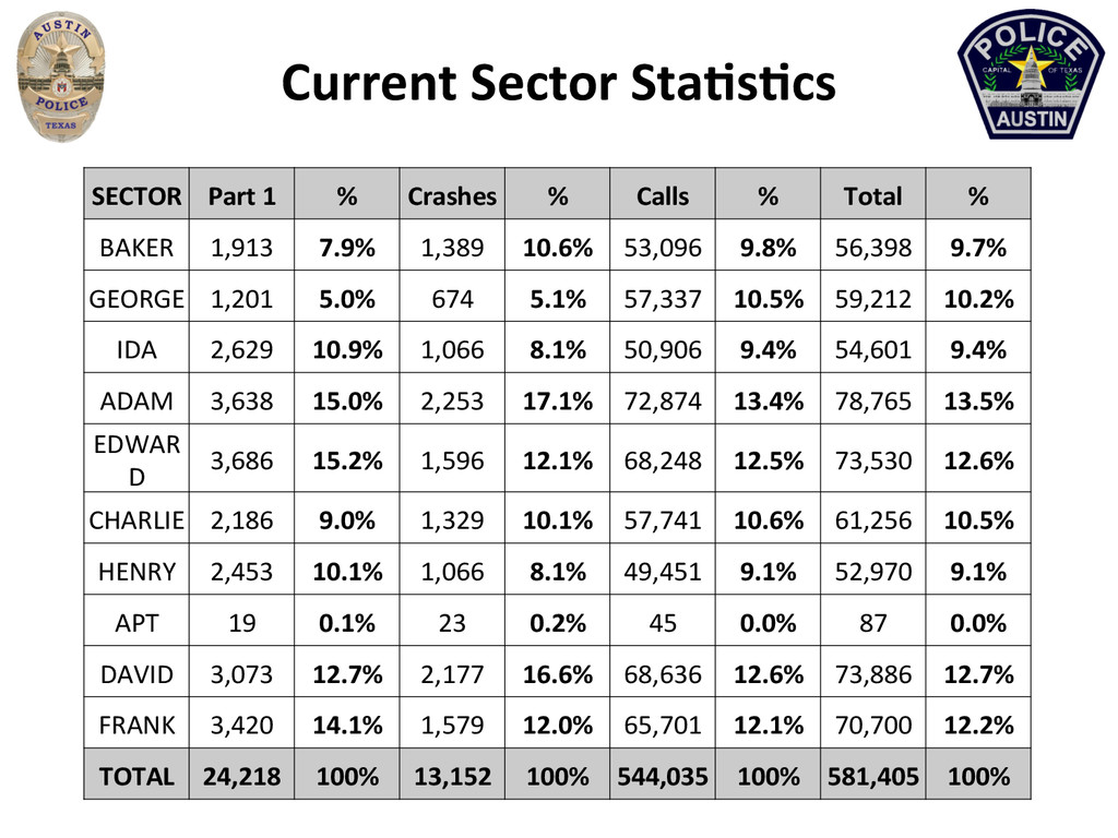
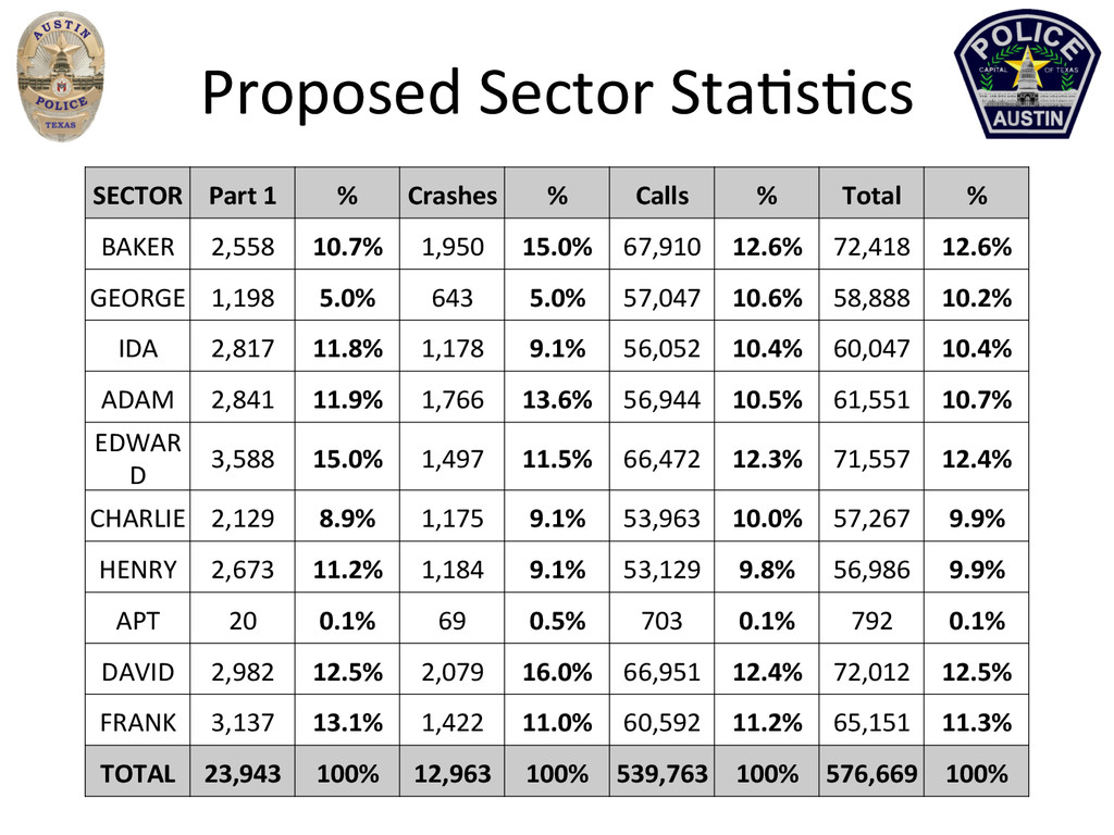
      Crashes   %   Calls   %   Total   %   BAKER   1,913   7.9%   1,389   10.6%   53,096   9.8%   56,398   9.7%   GEORGE   1,201   5.0%   674   5.1%   57,337   10.5%   59,212   10.2%   IDA   2,629   10.9%   1,066   8.1%   50,906   9.4%   54,601   9.4%   ADAM   3,638   15.0%   2,253   17.1%   72,874   13.4%   78,765   13.5%   EDWAR D   3,686   15.2%   1,596   12.1%   68,248   12.5%   73,530   12.6%   CHARLIE   2,186   9.0%   1,329   10.1%   57,741   10.6%   61,256   10.5%   HENRY   2,453   10.1%   1,066   8.1%   49,451   9.1%   52,970   9.1%   APT   19   0.1%   23   0.2%   45   0.0%   87   0.0%   DAVID   3,073   12.7%   2,177   16.6%   68,636   12.6%   73,886   12.7%   FRANK   3,420   14.1%   1,579   12.0%   65,701   12.1%   70,700   12.2%   TOTAL   24,218   100%   13,152   100%   544,035   100%   581,405   100%  
  4. Proposed  Sector  Sta:s:cs   SECTOR   Part  1   %

      Crashes   %   Calls   %   Total   %   BAKER   2,558   10.7%   1,950   15.0%   67,910   12.6%   72,418   12.6%   GEORGE   1,198   5.0%   643   5.0%   57,047   10.6%   58,888   10.2%   IDA   2,817   11.8%   1,178   9.1%   56,052   10.4%   60,047   10.4%   ADAM   2,841   11.9%   1,766   13.6%   56,944   10.5%   61,551   10.7%   EDWAR D   3,588   15.0%   1,497   11.5%   66,472   12.3%   71,557   12.4%   CHARLIE   2,129   8.9%   1,175   9.1%   53,963   10.0%   57,267   9.9%   HENRY   2,673   11.2%   1,184   9.1%   53,129   9.8%   56,986   9.9%   APT   20   0.1%   69   0.5%   703   0.1%   792   0.1%   DAVID   2,982   12.5%   2,079   16.0%   66,951   12.4%   72,012   12.5%   FRANK   3,137   13.1%   1,422   11.0%   60,592   11.2%   65,151   11.3%   TOTAL   23,943   100%   12,963   100%   539,763   100%   576,669   100%  
  5. Comparison  of  Sector  Areas   SECTOR   Acres   Miles

      %   BAKER   16566.96   25.89   9.5%   GEORGE   1374.905   2.15   0.8%   IDA   7469.305   11.67   4.3%   ADAM   39278.64   61.37   22.4%   EDWARD   18750.82   29.3   10.7%   CHARLIE   20375.24   31.84   11.6%   HENRY   13434.65   20.99   7.7%   AIRPORT   4169.945   6.52   2.4%   DAVID   26503.17   41.41   15.1%   FRANK   27127.12   42.39   15.5%   TOTAL   175050.8   273.53   100.0%   Current   Proposed   SECTOR   Acres   Miles   %   Change   BAKER   22645.01   35.38   12.9%   Gain   GEORGE   1374.59   2.15   0.8%   IDA   7504.21   11.73   4.3%   Gain   ADAM   34131.92   53.33   19.5%   Loss   EDWARD   15664.14   24.48   9.0%   Loss   CHARLIE   22464.20   35.1   12.8%   Gain   HENRY   14147.93   22.11   8.1%   Gain   AIRPORT   4229.09   6.61   2.4%   DAVID   30259.12   47.28   17.3%   Gain   FRANK   22592.70   35.3   12.9%   Loss   TOTAL   175012.90   273.47   100.0%  
  6. Hotshot  Calls   SECTOR   COUNT   %   ADAM

      2686   10.22%   APT   1686   6.42%   BAKER   1610   6.13%   CHARLIE   3059   11.64%   DAVID   2795   10.64%   EDWARD   3663   13.94%   FRANK   3417   13.01%   GEORGE   1755   6.68%   HENRY   2837   10.80%   IDA   2670   10.16%   OUTSIDE   93   0.35%   TOTAL   26271       SECTOR   COUNT   %   ADAM   2158   8.21%   -­‐2.01%   APT   1691   6.44%   +0.02%   BAKER   2202   8.38%   +2.25%   CHARLIE   2868   10.92%   -­‐0.72%   DAVID   2762   10.51%   -­‐0.13%   EDWARD   3586   13.65%   -­‐0.29%   FRANK   3189   12.14%   -­‐0.87%   GEORGE   1757   6.69%   +0.01%   HENRY   3088   11.75%   +0.95%   IDA   2857   10.88%   +0.72%   OUTSIDE   113   0.43%   +0.08   TOTAL   26271       2013 Hotshot Calls Current Sectors 2013 Hotshot Calls Proposed Sectors Difference   -­‐Decreases  in  five  sectors   -­‐Increase  in  one  sector,  small  increases  in  three  sectors   -­‐Significant  increase  in  Baker,  but  it  previously  had  the  lowest  of  the  nine  sectors,  and  it’s   s:ll  lower  than  six  other  sectors  
  7. Distric:ng  for  ArcGIS  Add-­‐on   •  Who  could  use  this?

      – Elec:ons   •  Vo:ng  precincts   •  State  &  US  Representa:ve  districts   – County/Local  Government  for  Census  prep   – Public  Safety  districts   •  Police   •  Fire/EMS   – Maintenance/Delivery  areas  
  8. Distric:ng  for  ArcGIS  Add-­‐on   •  FREE  download  available  from

     ESRI  (including   for  earlier  versions  of  ArcGIS  10.x)   •  Open  ArcMap   •  Ac:vate  the  Add-­‐on  in  the  Extensions  dialog   to  access  the  toolbar  
  9. What  is  a  Plan?   •  Workspace  and  Plan  

    –  Workspace  :  Geodatabase   –  Plan  :  Project  (.mxd)   •  Workspace  can  contain  mul:ple  Plans   •  Source  Data   –  Separate   •  Polygons  (shapefiles,  feature  classes,  coverage)   •  Ajribute  tables  with  common  ID  field;  NO  DUPLICATES   –  Single   •  Polygons  with  ajributes  included  
  10. Crea:ng  a  Plan   •  Assign  Source  Data   – 

    Geography  keyfield   •  (must  be  a  unique  ID)   •  Ajribute  Data  Fields   –  Universe  field   –  Op:mal-­‐value  field  
  11. Crea:ng  a  Plan   •  Fields  for  Sta:s:cs   Table

      –  Sum/Percent   –  Other  variables  to   consider  
  12. Edi:ng  Your  Plan   Can  change  District  names  in  the

      Symbology  tab  outside  of  edi:ng  session  
  13. Once  You’ve  Finished   •  Export  plan  (ASCII  text  for

     backup)   –  Useful  if  you  have  to  edit  the  plan  again  and  want  to   compare  the  original  to  current  edits   –  Plan  workspace  can  hold  mul:ple  plans   •  Export  to  Shapefile   •  Publish  to  AGOL  as  a  Layer  Package   •  Generate  Report  or  Layout   –  Report  is  a  text  file  of  sta:s:cs   –  Layout  adds  sta:s:cs  chart  and  table  to  generic  layout  
  14. Poten:al  Roadblocks   •  Do  not  save  as  .mxd;  open

     Plan  through  the   Distric:ng  toolbar   •  Can’t  change  District  pull-­‐down  while  block  is   selected   •  Plan  does  not  save  addi:onal  layers  added   (base  maps,  reference  data)   •  Source  Data  keyfields  need  to  be  same   datatype  and  unique  
  15. Final  Tips   •  Tutorial  PDF  available  on  download  page

      •  ESRI  support  available   – 1  advisor  but  she’s  very  responsive   •  distric:[email protected],  subject:  Distric:ng  for  ArcGIS   Sara.davis@aus:ntexas.gov  (512)974-­‐5496   Ron.mackay@aus:ntexas.gov  (512)974-­‐5022