Upgrade to Pro — share decks privately, control downloads, hide ads and more …

Exploiting Real-Time Data with ArcGIS GeoEvent Processor for Server by Dan Haag

Exploiting Real-Time Data with ArcGIS GeoEvent Processor for Server by Dan Haag

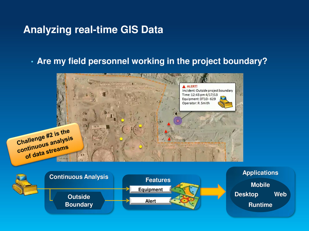
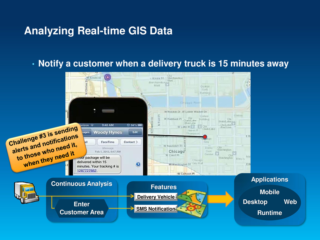
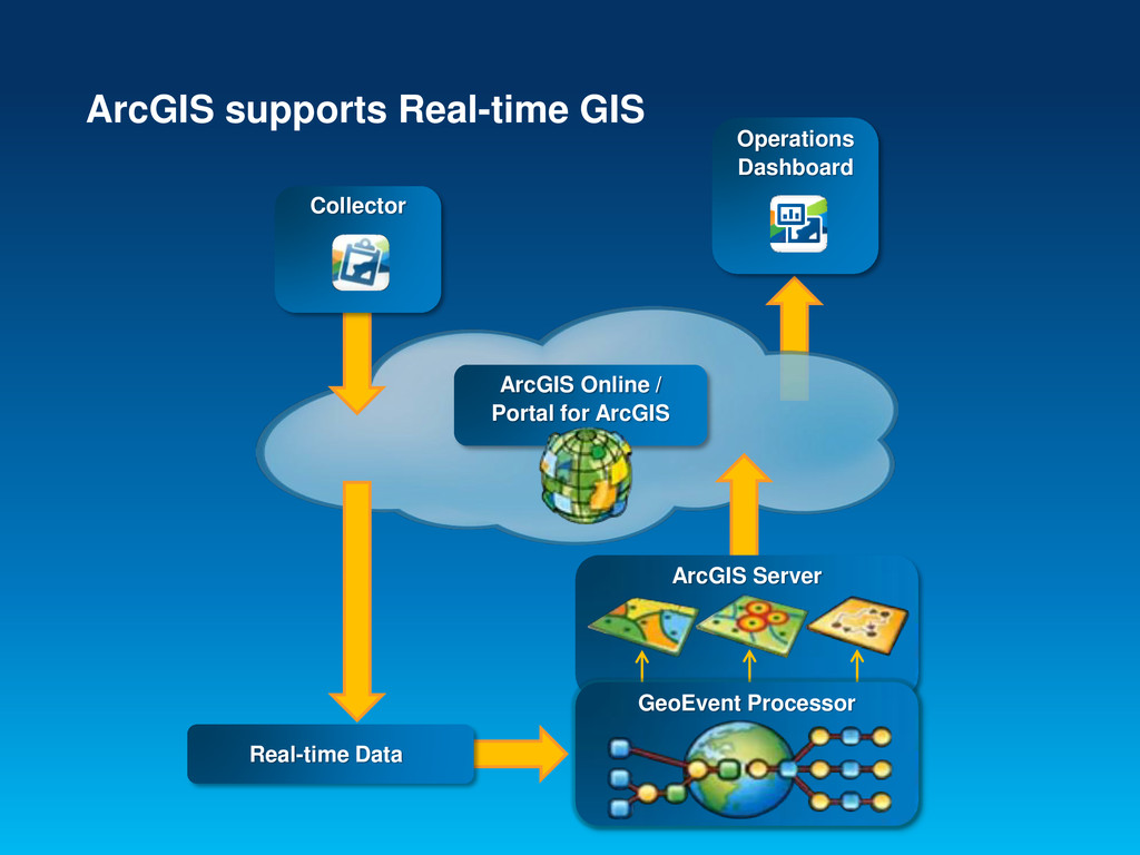
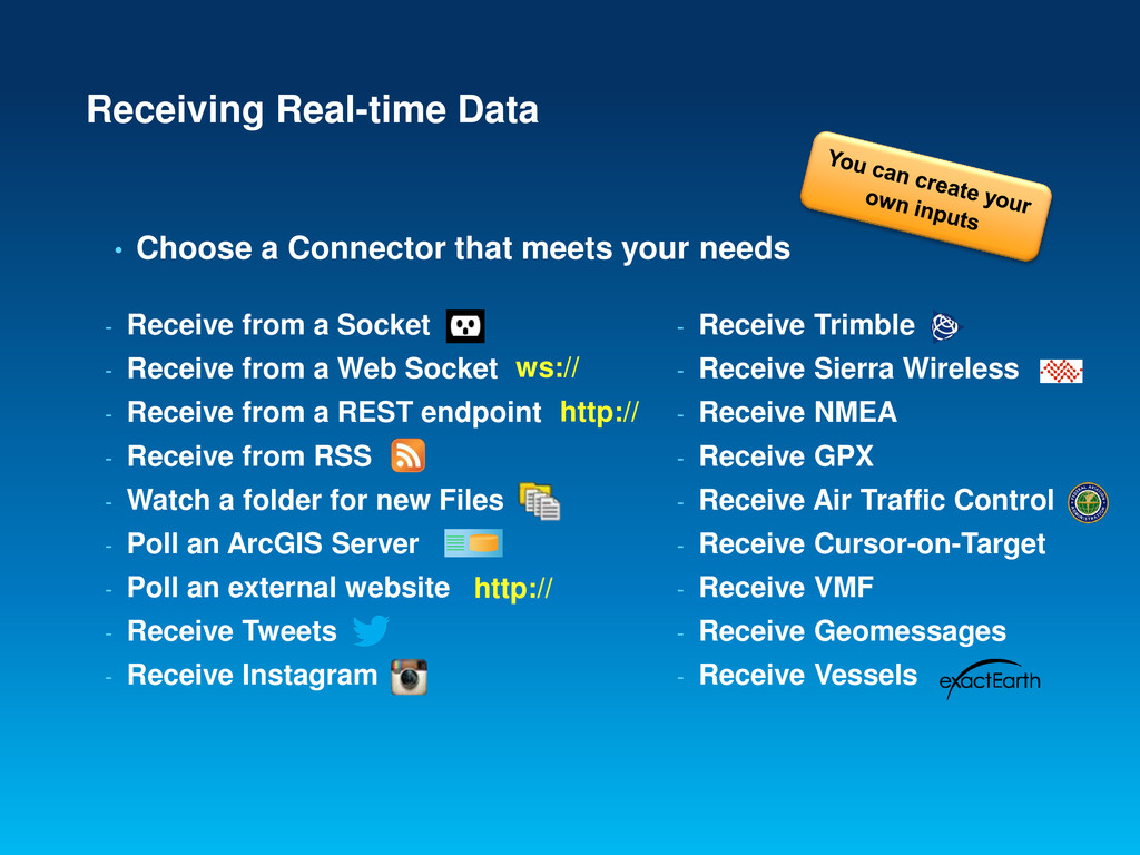
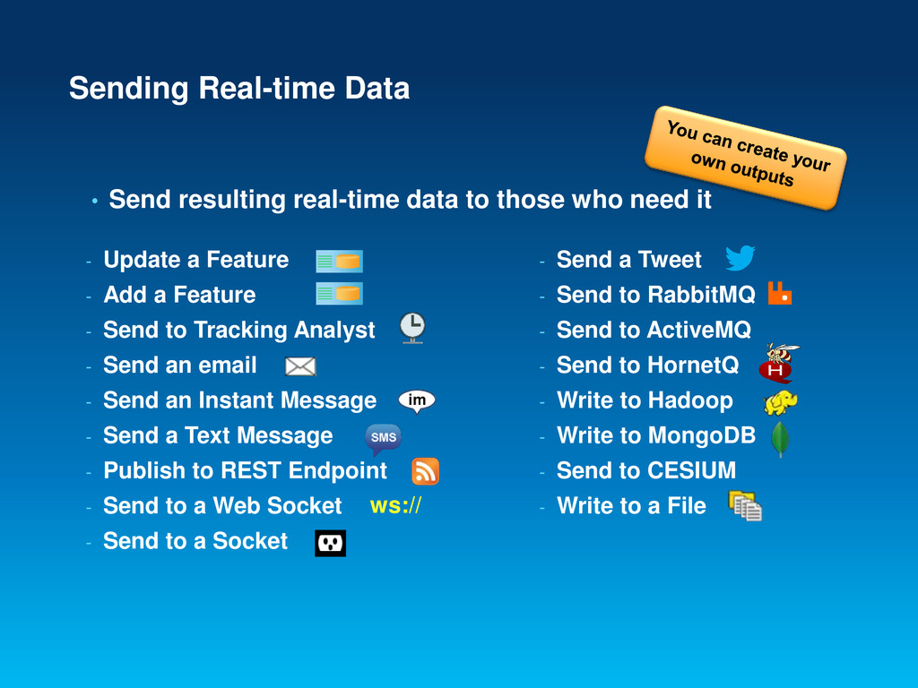
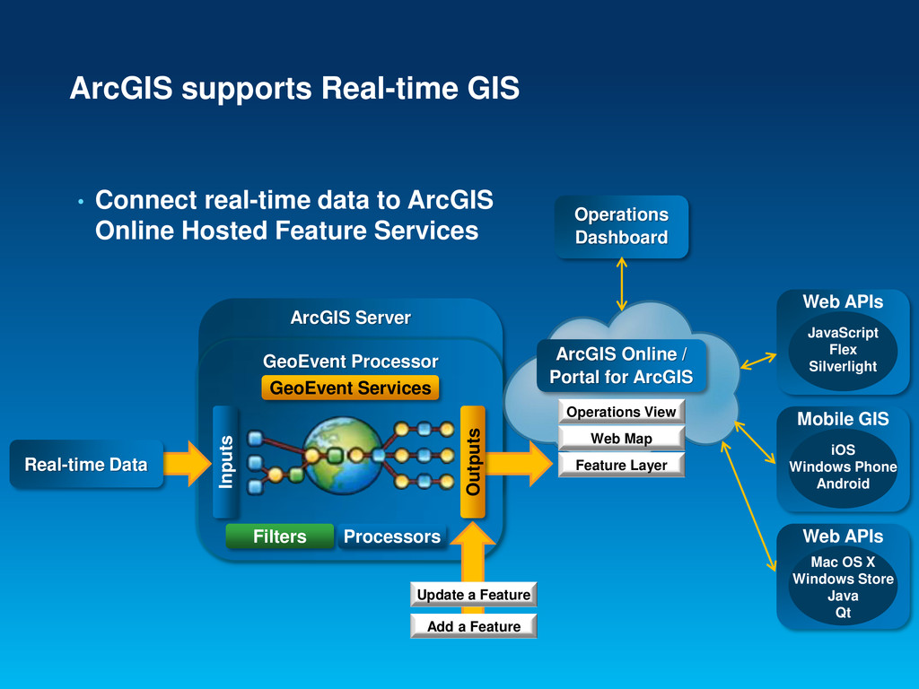
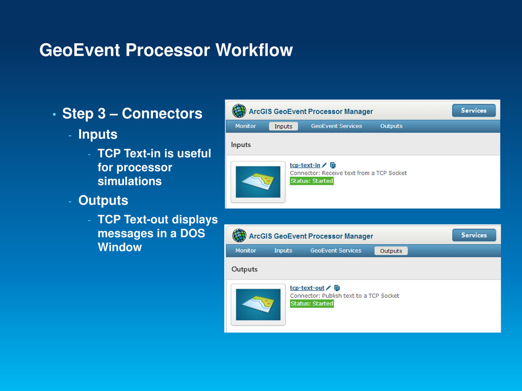
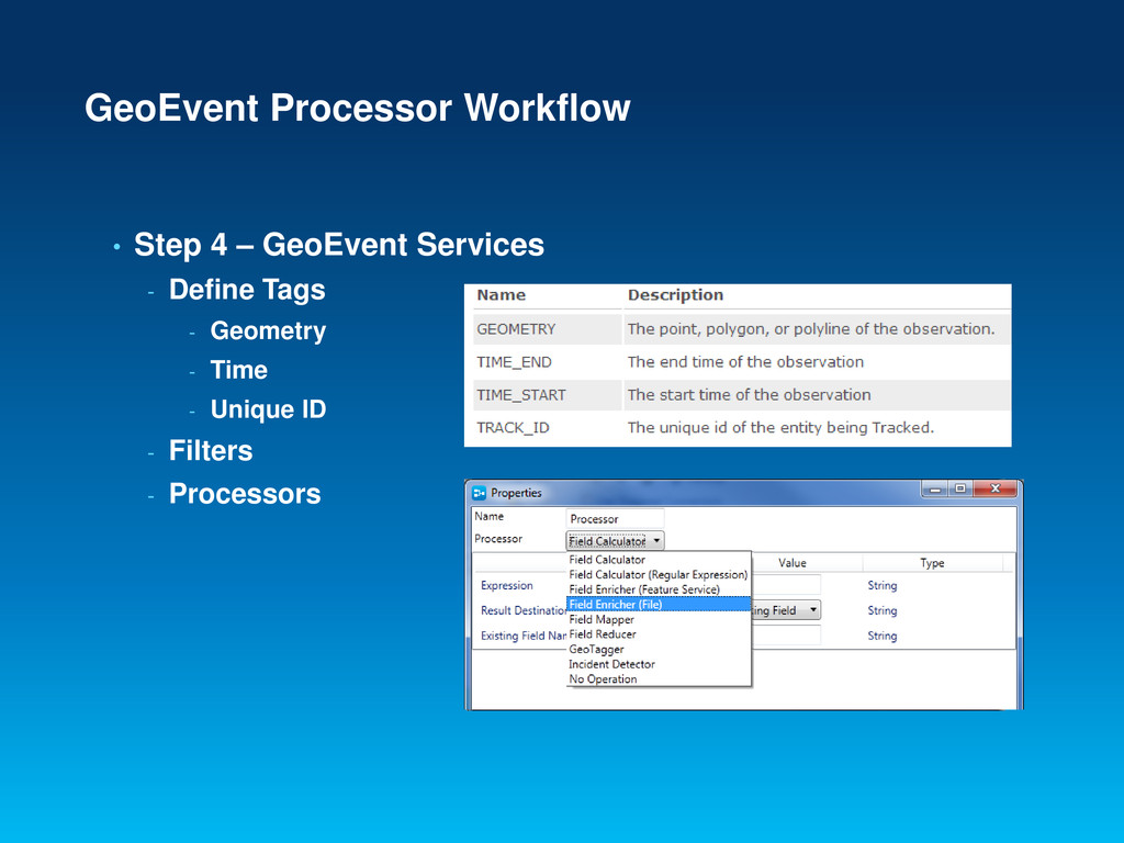
There is a growing demand among a wide range of communities to incorporate real-time data as a normal part of everyday GIS applications, workflows, and analysis. This session will demonstrate how an organization can integrate and exploit real-time data within the ArcGIS platform. Commercial organizations, transportation managers, public safety analysts, educators, and anyone else with a need to leverage streaming data can use GeoEvent Processor to receive and continuously analyze events from a variety of sources including mobile devices, in-vehicle GPS devices, online social media content, sensor networks, environmental monitoring devices, and more.

More Decks by Arkansas GIS Users Forum Conference

Other Decks in Technology

Transcript

  1. GeoEvent Processor Agenda • The challenges of working with Real-time

    Data - #1: To integrate incoming data as real-time GIS Data (inputs) - #2: The continuous analysis of incoming data streams - #3 Sending alerts and notifications to those who need it (outputs) • Introducing the GeoEvent Processor - Receiving inputs - Sending outputs - ArcGIS and Real-time Data - ArcGIS Online and Real-time Data
  2. GIS Data • Typically represents state at a specific moment

    in time - Historic - Current - Future Credit: iStockphoto/chris_lemmens
  3. • A continuous stream of events • Each event represents

    the latest state of a sensor - Emergency Response - Utility networks and warehouses - Envionmental Real-time GIS Data Features Applications Desktop Web Mobile Runtime Police Car Police Person Ambulance Storm Wind Temperature Earthquake Wildfire 110˚ Network Sensor Warehouse Item
  4. • Are my field personnel working in the project boundary?

    Analyzing real-time GIS Data Applications Desktop Web Mobile Runtime Features Equipment Alert Continuous Analysis Outside Boundary
  5. • Notify a customer when a delivery truck is 15

    minutes away Analyzing Real-time GIS Data Applications Desktop Web Mobile Runtime Features Delivery Vehicle SMS Notification Continuous Analysis Enter Customer Area
  6. Applications Desktop Web Mobile Runtime Features Alerts Connectors • Receives

    real-time streaming data • Performs continuous processing and analysis • Sends updates and alerts to those who need it ArcGIS GeoEvent Processor for Server Continuous Processing and Analysis ArcGIS Server GeoEvent Processor Connectors Feeds
  7. Operations Dashboard ArcGIS Online / Portal for ArcGIS ArcGIS supports

    Real-time GIS Collector ArcGIS Server Real-time Data GeoEvent Processor
  8. • Choose a Connector that meets your needs - Receive

    from a Socket - Receive from a Web Socket - Receive from a REST endpoint - Receive from RSS - Watch a folder for new Files - Poll an ArcGIS Server - Poll an external website - Receive Tweets - Receive Instagram - Receive Trimble - Receive Sierra Wireless - Receive NMEA - Receive GPX - Receive Air Traffic Control - Receive Cursor-on-Target - Receive VMF - Receive Geomessages - Receive Vessels Receiving Real-time Data http:// ws:// http://
  9. • Send resulting real-time data to those who need it

    Sending Real-time Data - Update a Feature - Add a Feature - Send to Tracking Analyst - Send an email - Send an Instant Message - Send a Text Message - Publish to REST Endpoint - Send to a Web Socket - Send to a Socket ws:// - Send a Tweet - Send to RabbitMQ - Send to ActiveMQ - Send to HornetQ - Write to Hadoop - Write to MongoDB - Send to CESIUM - Write to a File
  10. • Connect real-time data to ArcGIS Server Feature Services ArcGIS

    supports Real-time GIS ArcGIS Server GeoEvent Processor Operations Dashboard ArcGIS Online / Portal for ArcGIS Operations View Web Map Feature Layer Update a Feature Add a Feature Real-time Data GeoEvent Services Processors Outputs Filters Inputs Web APIs JavaScript Flex Silverlight Mobile GIS iOS Windows Phone Android Web APIs Mac OS X Windows Store Java Qt
  11. • Connect real-time data to ArcGIS Online Hosted Feature Services

    ArcGIS supports Real-time GIS ArcGIS Server GeoEvent Processor Operations Dashboard ArcGIS Online / Portal for ArcGIS Operations View Web Map Feature Layer Update a Feature Add a Feature Real-time Data GeoEvent Services Processors Outputs Filters Inputs Web APIs JavaScript Flex Silverlight Mobile GIS iOS Windows Phone Android Web APIs Mac OS X Windows Store Java Qt
  12. GeoEvent Processor • Software Components - GeoEvent Manager - REST

    Endpoint - GeoEvent Service Designer - GeoEvent Simulator
  13. GeoEvent Processor Workflow • Step 1 – Register Data Stores

    - Folders - Input - Output - Servers - Local - ArcGIS Online
  14. GeoEvent Processor Workflow • Step 2 – Publish Feature Services

    - ArcGIS Server - Data must be in SDE - Use coordinate system as incoming data - ArcGIS Online - Hosted Feature Service - Requires Organization Account - Data will be placed in SDE automatically
  15. GeoEvent Processor Workflow • Step 2 – GeoEvent Layers -

    GeoEvent Definitions - Incidents - Trucks - Emergency Vehicles - GeoFences - Storms/Hazards - Service Areas - Notification Areas
  16. GeoEvent Processor Workflow • Step 3 – Connectors - Inputs

    - TCP Text-in is useful for processor simulations - Outputs - TCP Text-out displays messages in a DOS Window
  17. GeoEvent Processor Workflow • Step 4 – GeoEvent Services -

    Define Tags - Geometry - Time - Unique ID - Filters - Processors
  18. GeoEvent Processor Workflow • Step 4 – GeoEvent Services -

    GeoEvent Service Designer Filters (GeoFence Conditions) Processors Input Output (Add or Update Features) Output (Report by Exception)