Upgrade to Pro — share decks privately, control downloads, hide ads and more …

Can't See the GIS for the Clouds by Matthew Charton

Can't See the GIS for the Clouds by Matthew Charton

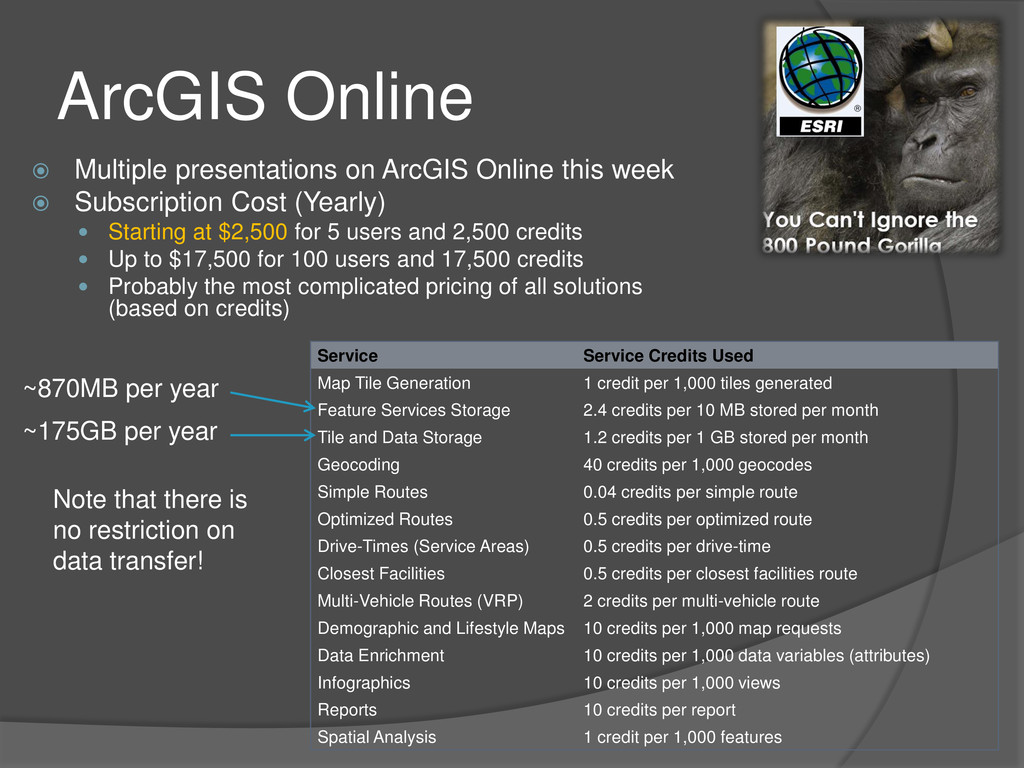
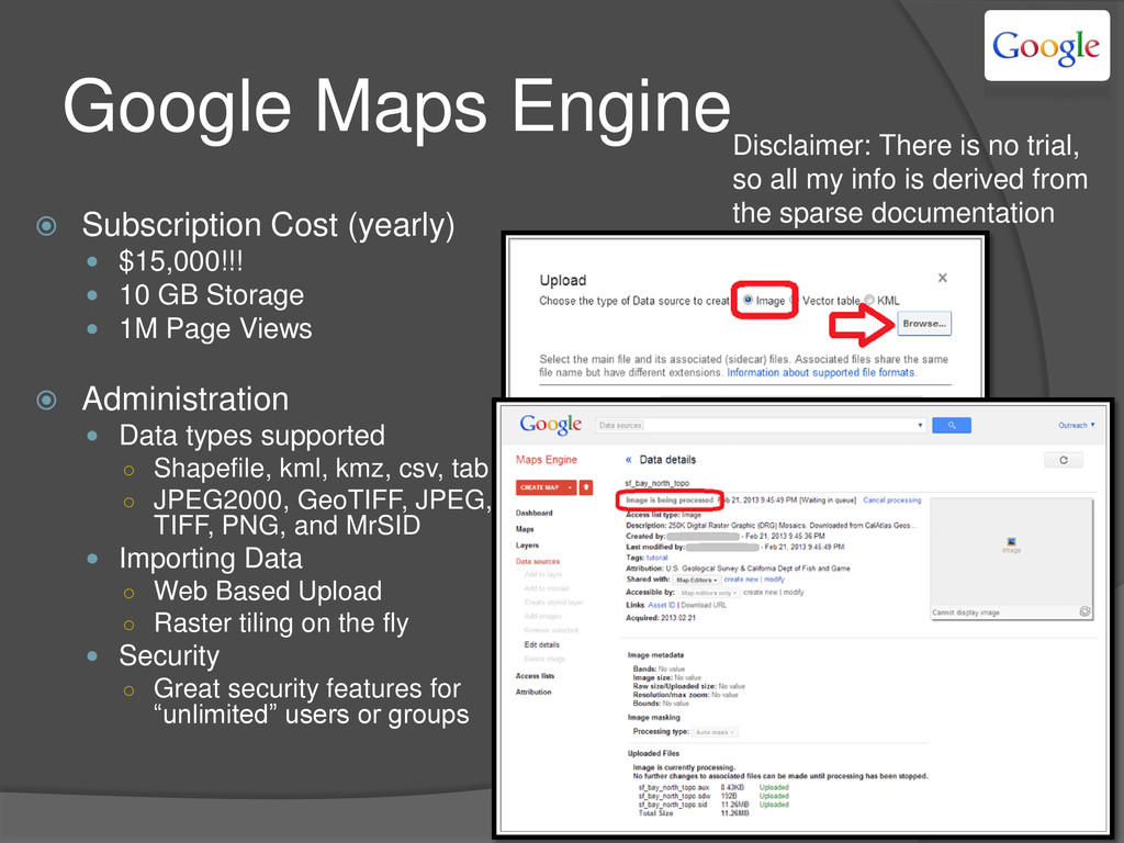
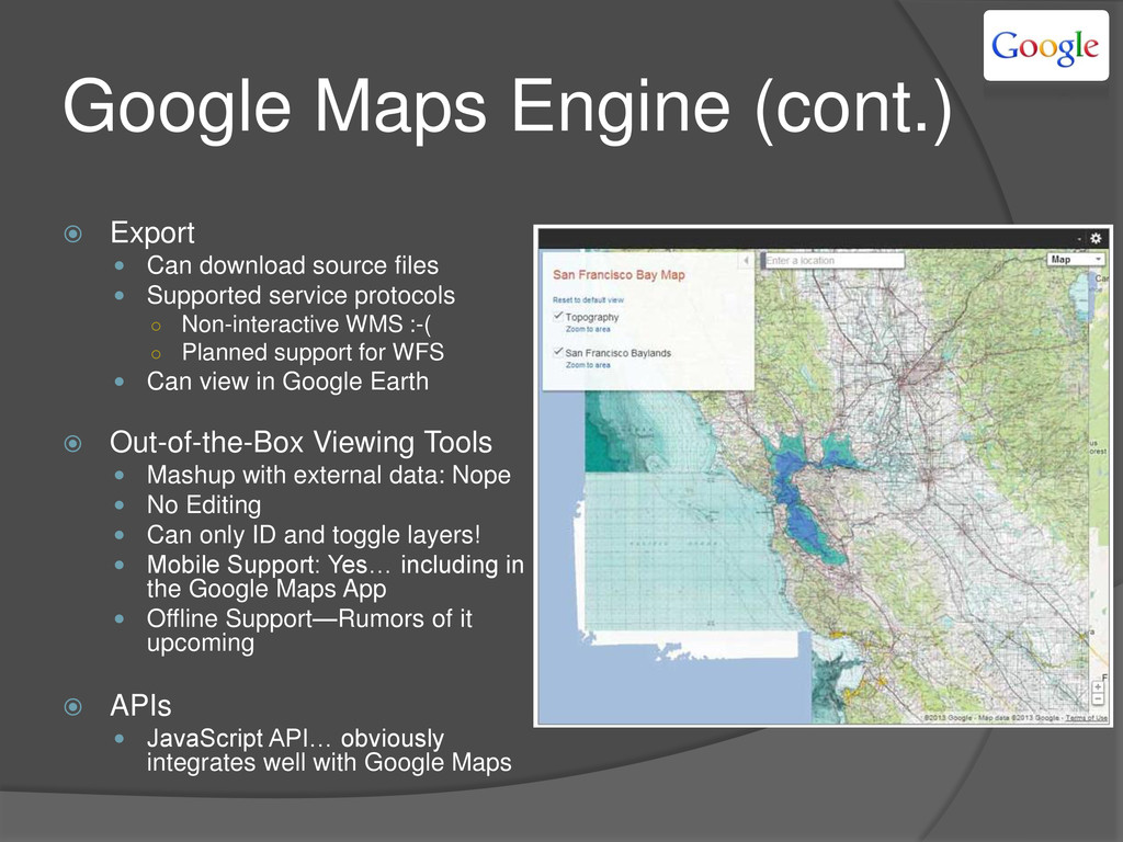
Looking at the options for getting your GIS data on the web can be overwhelming these days. Where once there was only ArcIMS, there is now a plethora of “cloud” options. Join us as we take a quick look through some of the most common venues and analyze the differences and benefits of each.

More Decks by Arkansas GIS Users Forum Conference

Other Decks in Technology

Transcript

  1. Cloud GIS Options  ArcGIS Online  Google Maps Engine

     MapBox  CartoDB  GeoCommons - Nevermind… ESRI took them over  MangoMap  GIS Cloud  Google Maps + Fusion Tables  Fulcrum You have options, just like you do for your email… There is more out there than just ArcGIS Online Widely used non-ESRI solutions Less traditional, but maybe all you need?
  2. Cloud GIS Comparison Points  It’s all about what you

    have  Money: range from free to $15k/year  Time: For the cheaper range, you usually have to work harder to get your data into the cloud and/or spend time symbolizing or otherwise administering your map.  Expertise: Some solutions are more geared towards developers. They may offer amazing tools via their APIs but only very simplistic out-of-the-box viewers. --How do I choose?
  3. Cloud GIS Comparison Points (cont.)  …And what you need

    to do  Just displaying some data  Editing  Security  Mesh different sources  Consuming it in many places  Offline access  Customization
  4. Cloud GIS Comparison Points (cont.)  Subscription Cost  Administration

     How to get data in / what data types are supported  Security  Export  Getting data out  Supported service protocols  Out-of-the-Box Viewing Tools  Mashup with external data  Editing  Mobile Support  Offline Support  APIs  Other Specific Advantages/Disadvantages
  5. ArcGIS Online  Multiple presentations on ArcGIS Online this week

     Subscription Cost (Yearly)  Starting at $2,500 for 5 users and 2,500 credits  Up to $17,500 for 100 users and 17,500 credits  Probably the most complicated pricing of all solutions (based on credits) Service Service Credits Used Map Tile Generation 1 credit per 1,000 tiles generated Feature Services Storage 2.4 credits per 10 MB stored per month Tile and Data Storage 1.2 credits per 1 GB stored per month Geocoding 40 credits per 1,000 geocodes Simple Routes 0.04 credits per simple route Optimized Routes 0.5 credits per optimized route Drive-Times (Service Areas) 0.5 credits per drive-time Closest Facilities 0.5 credits per closest facilities route Multi-Vehicle Routes (VRP) 2 credits per multi-vehicle route Demographic and Lifestyle Maps 10 credits per 1,000 map requests Data Enrichment 10 credits per 1,000 data variables (attributes) Infographics 10 credits per 1,000 views Reports 10 credits per report Spatial Analysis 1 credit per 1,000 features Note that there is no restriction on data transfer! ~175GB per year ~870MB per year
  6. ArcGIS Online (cont.)  Administration, mashups, importing, and APIs 

    Not just the 800 lb. Gorilla because it’s ESRI… it really is the most feature rich of the options we’re talking about today  Note  ArcGIS Online hosted services ONLY support Feature Level and Cached Tile Services
  7. Google Maps Engine  Subscription Cost (yearly)  $15,000!!! 

    10 GB Storage  1M Page Views  Administration  Data types supported ◦ Shapefile, kml, kmz, csv, tab ◦ JPEG2000, GeoTIFF, JPEG, TIFF, PNG, and MrSID  Importing Data ◦ Web Based Upload ◦ Raster tiling on the fly  Security ◦ Great security features for “unlimited” users or groups Disclaimer: There is no trial, so all my info is derived from the sparse documentation
  8. Google Maps Engine (cont.)  Export  Can download source

    files  Supported service protocols ◦ Non-interactive WMS :-( ◦ Planned support for WFS  Can view in Google Earth  Out-of-the-Box Viewing Tools  Mashup with external data: Nope  No Editing  Can only ID and toggle layers!  Mobile Support: Yes… including in the Google Maps App  Offline Support—Rumors of it upcoming  APIs  JavaScript API… obviously integrates well with Google Maps
  9. Google Maps Engine (cont.)  Disadvantages  No trial 

    New and nobody seems to know anything about it  Very simple Out-of-the-Box Application  Info Windows require knowledge of HTML  Advantages  Can’t beat the processing and speed of their tiling  Very simple to administer and create maps (typical Google)  Final Thoughts  Huge price tag for not much functionality  It may not be worth it now… but keep an eye on it… this is Google after all.  May be cost effective for those who already have a Google Business License
  10. MapBox (+ TileMill)  Subscription Cost (monthly)  Free (3000

    page views & 50 MB)  From $5 (10000 page views & 250 MB)  To $150 (300000 page views & 10GB)  Administration  Data types supported ◦ ONLY supports MBTiles ◦ Created via TileMill which supports: shp, kml, GeoJSON, GeoTiff, PostGIS, CSV, SQLite  Importing Data ◦ TileMill > MapBox ◦ ArcGIS > Arc2Earth Toolbar > TileMill > MapBox ◦ Keeps ArcMap Symbology!!!  Security ◦ None beyond toggling search-ability Hosts Tiles Creates Tiles There has been a lot of interest in going from ArcMap -> MapBox or vice versa, so there are a number or random tools attempting this (ArcBruTile, mbutil, Arc2Earth, etc.) ArcMap w/ Arc2Earth Toolbar Exported to TileMill and Uploaded to MapBox
  11. MapBox (+ TileMill) (cont.)  Export  Getting data out

    ◦ Nope  Supported service protocols ◦ Only as an MBTile Service ◦ ArcGIS 10.2 supports MBTiles as does ArcGIS Online  Out-of-the-Box Viewing Tools  Very simple ◦ Identify ◦ Legend ◦ Address Search  Mobile Support: yup  Really great usage reporting though  APIs  This is the focus of MapBox  REST, JavaScript, iOS  Still Display (not data) centric
  12. MapBox (+ TileMill) (cont.)  Disadvantages  Focused on Displaying

    data (even the APIs)  Very simple viewer  Developer-Focused (even requires CSS/HTML for tooltips and legend)  Extended process of importing data  MBTiles can be HUGE to upload  Advantages  Great support and large community of users (USA Today, Slate, The Guardian, NPR, Pew Research, FCC, foursquare, evernote….)  Very easy to use (after you import your data)  Can utilize cartography created via ArcMap  Final Thoughts  MapBox has always been about the cartography… though it is focused on the developer.  This could be a great way to create basemaps that are later mashed up with other resources.
  13. CartoDB  Subscription Cost (monthly)  Free (5 tables, 10,000

    map views, & 5MB)  From $29 (10 tables, 50,000 map views, & 50MB)  To $149 (Unlimited tables, 500,000 map views, & 500MB)  (Enterprise ranging to $2499!)  Administration  Data types supported ◦ Shp, xlsx, csv, gpx  Importing Data ◦ Web based import only  Security ◦ None “Built by developers for developers” Utilizes “Tables” and “Visualizations” instead of Layers and Maps
  14. CartoDB (cont.)  Export  Getting data out: Nothing other

    than via API  Supported service protocols: None!!!  Out-of-the-Box Viewing Tools  Simplistic viewer tools: Search Data, ID, Legend  Mashup with external data ◦ Supports MapBox Basemaps! ◦ Supports Google and Bing Tiles  Great Cartographic and Query Tools (before publishing)  No Editing or Offline Support  Mobile Support: Yup  APIs  This is what CartoDB focuses on  API support for 10 languages/technologies! (including iOS, .NET, and Python)  Editing data is a key feature here
  15. CartoDB (cont.)  Disadvantages  Really designed for developers, all

    the power is in the APIs  Weak and simplistic Out-of-the-Box Viewer  Advantages  Built for data analysis and interaction  Dynamic Tile or Feature Level Services  Final Thoughts  Great in combination with MapBox if you have the development skills
  16. MangoMap  Subscription Cost (monthly)  Free!  Future Pricing:

    ◦ $5 = 1 map ◦ $150 = unlimited maps  Unlimited storage and views!  Administration  Data types supported ◦ Only Shapefiles ◦ Planned support for GeoTIFFs  Importing Data ◦ Web based import  Security ◦ Password protect each map! Made for the non-developer Extremely simple administration
  17. MangoMap (cont.)  Export  Getting data out ◦ Download

    original files  Supported service protocols ◦ WMS ◦ Future Support of WTMS  Out-of-the-Box Viewing Tools  No Mashup, Editing, or Offline  Mobile Support: Yup  Generally simplistic: Legend, Identify, Print, Address Search  Very cool advanced search using either full text or custom queries  Couple alternative templates (“more coming”)  Supports Bing (but not Google) tiles  APIs  None!
  18. MangoMap (cont.)  Disadvantages  No APIs  Still a

    little buggy…but it’s very new  Advantages  Can’t get cheaper than free (especially with unlimited storage!)  Very simple to use… No coding necessary!!  Great out-of-the-box querying  Document based security (instead of user)  Final Thoughts  Great place to get your feet wet  Perhaps the best solution for the quick and easy one-off map
  19. GIS Cloud  Subscription Cost (monthly)  Free (10,000 features

    & 100 MB  $55 per user (200,000 features & 1GB)  Storage does not include features; storage upgrades available  Administration  Data types supported ◦ Shp, mif, mid, tab, kml, gpx, csv, xlsx ◦ Tif, tiff, jpg, gif  Importing Data ◦ Web based import ◦ Free ArcMap Extension! (though it has fairly limited symbology support) ◦ Upload from web (e.g., FTP) :-)  Security ◦ Almost Identical to ArcGIS Online Most Comparable to ArcGIS Online ArcMap w/ GIS Cloud Toolbar Uploaded to GIS Cloud
  20. GIS Cloud (cont.)  Export  Getting data out ◦

    Shp, mif, kml, dxf, csv  Supported service protocols ◦ WMS  Out-of-the-Box Viewing Tools  This is actually closer to a Cloud GIS “desktop” software  Mashup with external data ◦ MapBox, Other GIS Cloud Maps, Bing/Google/etc., WMS/WTMS/TMS/WFS  Editing: Yup!  Mobile and Offline Support!!  Most traditional GIS features  APIs  REST and JavaScript  Very weak APIs with low functionality
  21. GIS Cloud (cont.)  Disadvantages  Bad APIs  No

    simple viewer  Quirky  Advantages  Great as a low featured complete GIS  Great for data collection… offline mobile editing!  Full featured security  Final Thoughts  This is very close to ArcGIS Online  At first glance seems pricey since an editor must login…  But remember there is a free tier!
  22. Google Maps + Fusion Tables  Subscription Cost (monthly) 

    From Free (15 GB)  To $800 (16 TB)  Administration  Data types supported ◦ Xlsx, ods, csv, tsv, txt, kml  Importing Data ◦ Web Based Import ◦ Google Drive Desktop (folder sync)  Security ◦ Full featured based on users Important Note: Only works with @gmail.com accounts
  23. Google Maps + Fusion Tables (cont.)  Export  Getting

    data out ◦ Csv, kml, kml network link!  Supported service protocols ◦ none  Out-of-the-Box Viewing Tools  Mashup with external data: Nope  Editing: Yup  Mobile Support: Yup  Offline Support: Not really  Tools include identify, filter, search  APIs  JavaScript
  24. Google Maps + Fusion Tables (cont.)  Disadvantages  No

    typical GIS viewer  Less supportive of polyline and polygon data  Can’t mashup  Technically still experimental  Advantages  Create and share editable views  Very cheap  Friendly and easy to use  Final Thoughts  Overlooked solution  Like cartoDB this is very data-centric, and could be a very simple and cost-effective way to achieve collaborative data collection
  25. Fulcrum  Subscription Cost (monthly)  Free (1 user &

    3 apps)  From $29 (1 user)  To $749 (50 users)  Administration  Data types supported ◦ Csv (only points)  Importing Data ◦ Web based import  Security ◦ Full featured user based More a data-collector Drag and Drop Form Elements Easy but Thorough Field Properties
  26. Fulcrum (cont.)  Export  Getting data out ◦ Csv,

    kml, shp, GeoJSON ◦ Kml network link!  Supported service protocols ◦ Nope  Out-of-the-Box Viewing Tools  Mashups with MBTiles  Supports editing and mobile  Offline Support: Yup… including offline maps.  Identify, reports, printing  APIs  REST (A good use for this would be to sync with in-house DB)
  27. Fulcrum (cont.)  Disadvantages  No line or polygon support

     Not a general public use viewer  Advantages  The most stable GIS data-collector app that I have seen (especially for offline editing)  Extremely easy to create forms and use the application  Final Thoughts  Of all options (including ArcGIS Online and most custom solutions I’ve seen), this is the best data-collector I have seen (for points)  Could get pricey… however, I could not find anything in the License Agreement that stated only one person could use a login…
  28. Side By Side Summary Cost Data Types Importing Security Protocols

    Out-of-the- Box APIs ArcGIS Online 2,500 + yearly Many ArcGIS / Web User Based Typical ESRI Service Protocols Advanced Yup, strong GME (no free) 15,000 Yearly Many Web Only User Based Non- interactive WMS Simple Yup, typically strong and easy MapBox 5 – 150 Monthly MBTiles (created from many) ArcMap ext. / TileMill / Web Nope MBTiles Simple Yup (though just for display) CartoDB 29 – 150 Monthly Shp, xlsx, csv, gpx Web Only Nope None Simple Many, very strong MangoMap Free for now 5 -150 Monthly Only Shapefiles Web Only Map Based WMS Simple (but great querying) Nope GIS Cloud 55 per User Many ArcMap ext. / Web User Based WMS Very (maybe too?) advanced Yes, but weak Fusion Tables Free (additional storage up to 800 Monthly) Xlsx, ods, csv, tsv, txt, kml Google Drive Desktop / Web User Based None Simple Yup Fulcrum 29 – 750 Monthly Csv (points) Web User Based None... (Kml network) Very impressive for editing Just REST
  29. Final Thoughts (Winners and Losers) Major Winners Standout Losers Just

    Display Data MangoMap Fulcrum Map Tools ArcGIS Online, GIS Cloud GME, and most of the rest Editing Fulcrum, GIS Cloud, ~Fusion MangoMaps, GME, MapBox Secure my Data GME, GIS Cloud, ~MangoMaps MapBox, CartoDB Mashup (Internally) ArcGIS Online, GIS Cloud GME, MapBox, MangoMaps Mashup (Externally) ArcGIS Online, MangoMap, GIS Cloud CartoDB, Fusion Offline Support Fulcrum, GIS Cloud All the rest Customization ArcGIS Online, CartoDB MangoMap, ~GIS Cloud What I need to do…
  30. Final Thoughts (Winners and Losers) What I have… None Lots

    Money MangoMaps, Fusion ArcMap Time MangoMaps GIS Cloud, CartoDB + MapBox Expertise MangoMaps, Fusion, ArcMap CartoDB + MapBox